-
Hello, please take a minute to check out our awesome content, contributed by the wonderful members of our community. We hope you'll add your own thoughts and opinions by making a free account!
You are using an out of date browser. It may not display this or other websites correctly.
You should upgrade or use an alternative browser.
You should upgrade or use an alternative browser.
Pattern February 2024
- Thread starter SD
- Start date
Larry (@GaWx) on American seems optimistic
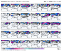
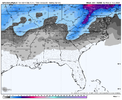
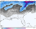
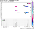
The potential for significant SE wintry precip 2/15-20, especially 2/17-20, is not at all going away and is if anything increasing as we get closer while the big picture doesn’t change. At least 75% of the last 3 GEFS runs ending with the 6Z have SE US wintry precip outside of the mountains somewhere within Feb 15-20. About 50% of the 6Z members have it including outside of NC with 4 of the 30 even as far south as N FL.
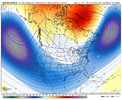
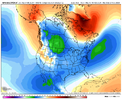
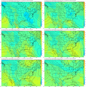
It is hard to look better than this 10-15 days out. The big picture is still very much intact with a hard to beat combo of a very strong -AO, moderate +PNA, -EPO, neutral to -NAO, strong subtropical jet/split flow, and the tendency for 50/50 lows (which tend to hold cold in longer). Moderate+ El Niño climo is quite supportive, too. It never hurts to have analogs on your side.
I hope to post more about the very strong -AO later as far as El Niño analogs are concerned.
Well according to Webb’s research our area does historically do better with miller B’s than Miller A’s. You can always count out a good strong FGEN forcing on the front end like we saw in January 2022Just hope it isn’t to suppressive by sticking around, but normally they trend quicker closer to go time. Give me a Miller B mixed bag with front end snow to mix, that’s the only way to win seemingly the last decade. but that’s a good look
Stormlover
Member
I like to see the snowfall footprint oriented more west to east or wsw to ene. You see that signal somewhat showing up in the ensembles. That is a good sign.The 18z GEFS had the biggest run in the extended for this period.
View attachment 145288View attachment 145289View attachment 145293
LickWx
Member
Brad tweaking . I don’t have any solid irrefutable evidence on this but I personally believe that late February and early March have the highest potential to have the most extreme negative departures as the arctic has not really warmed much… I could be wrong though but March 1960 is the most anomalous month in history and it’s not even close. December 2015 is more normal than March 1960.
? Man he’s really sweating this one. He thought he had a tap-in birdie on a snowless winter but he walked up onto the green and realized it’s actually a 5 footer downhill
iGRXY
Member
Somebody want to let him know that February has been one of the best times in winter for the western carolinas for winter storms? He's trying too hard right now
Forevertothee
Member
He also went on to say in comments, "there is no arctic air on the way and no winter set-up. The cool anomalies are caused by rain and clouds, not cold air. That's why it's so warm north of the storm track." And later in comments "no signs of ridge and all the cold air is on the other side of the hemisphere in the long range." Not what I wanted to read this evening.
This is the same man that shows a graph and constantly reminds people February is the snowiest month in Charlotte. I guess all that snow falls in the first half of February. This is a defeated meteorologist that's speaking with emotion just like we do on here. I get what he's saying, 15 below the average high won't do it. But 15 below the average low will. Plenty of snow days warmed to the 40s later in the day. Plenty also started in the 40s and radiational cooling took over. Even I can't believe this man said this. Especially still 10+ days out.
He saw his foot of snow at a met conference in Tahoe a few weeks ago and now is full on anti snow troll, it’s weirdHe also went on to say in comments, "there is no arctic air on the way and no winter-set. The cool anomalies are caused by rain and clouds, not cold air. That's why it's so warm north of the storm track. And later in comments "no signs of ridge and all the cold air is on the other side of the hemisphere in the long range."
It doesn’t take a lot of risk to bet against snow around here especially late into February, but his reasoning isn’t merit based. Like you said 15 below the avg low would be a high ratio Feb snowstorm. Or make a few tweaks to a setup and -15BN mid day becomes -25BN with a low bombing out in the right spot funneling cold air down the backside of the mountain. We’ve got to score one here and never let him hear the end of it.I guess we'll see if he ends up right
Tarheelwx
Member
If you have a 55/35 avg, that means the avg for the day is 45. So 15 below would be 30 - in other words the snow would start midday at 35 and bottom out under heavy precip at 25. So 15 below this time of year is PLENTY cold.
TW
TW
LukeBarrette
im north of 90% of people on here so yeah
Meteorology Student
Member
2024 Supporter
2017-2023 Supporter
GFS wants a solid coastal system on the 14th for Mid-Atlantic regions. Certainly would help things. With each system the snow footprint should shift south… putting many in the 20th timeframe in a good spot.

