-
Hello, please take a minute to check out our awesome content, contributed by the wonderful members of our community. We hope you'll add your own thoughts and opinions by making a free account!
You are using an out of date browser. It may not display this or other websites correctly.
You should upgrade or use an alternative browser.
You should upgrade or use an alternative browser.
Wintry February 19-21, 2020 Winter Storm
- Thread starter Six Mile Wx
- Start date
snowlover91
Member
Here's my first call map w/ actual totals. I think the northern coastal plain and NE piedmont is going to get clocked.
View attachment 35515
I’d be thrilled with 3-6” of snow and sleet here. Considering many here including myself had given up on winter in NC I’ll take this in a heartbeat. I hope the higher nam totals are right though, I want a foot ?
Right, which is way seeing the RGEM ramp up gives me reason to start liking those higher totals. Today's 12z run should be very tellingIMO the model to follow is the 3km NAM and RGEM later today blended together. Everything has been trending to the overall NAM idea. Rgem caved, euro caved, and other models have too in recent days. The NAM and RGEM blend at 12z today should be pretty close to what actually happens. The 6z RGEM was a massive jump towards the NAM too with widespread 4-5” amounts and still snowing at the end of the run on pivotal.
Webberweather53
Meteorologist
I’d be thrilled with 3-6” of snow and sleet here. Considering many here including myself had given up on winter in NC I’ll take this in a heartbeat. I hope the higher nam totals are right though, I want a foot ?
Yeah I think if you end up w/ a bunch of mixing, you'll still have a really good chance to at least salvage 3-4" of IP & snow.
B
Brick Tamland
Guest
Here's my first call map w/ actual totals. I think the northern coastal plain and NE piedmont is going to get clocked.
View attachment 35515
Good call. I am thinking the same.thing, but I still think that sweet spot will dip down and cover Wake. I can't move from my prediction I made a couple of days ago of Wake northeast to Norfolk now. Gotta stick with my guns.
snowlover91
Member
Webberweather53
Meteorologist
Good call. I am thinking the same.thing, but I still think that sweet spot will dip down and cover Wake. I can't move from my prediction I made a couple of days ago of Wake northeast to Norfolk now. Gotta stick with my guns.
It's a tough call imo, I think mixing w/ IP will damper totals in the Triangle, and to be quite honest 3-6" might be a bit on the conservative side given how this is trending wetter/further NW (as it often does).
snowlover91
Member
Right, which is way seeing the RGEM ramp up gives me reason to start liking those higher totals. Today's 12z run should be very telling
Yeah I’m expecting a full cave of RGEM by 12z. If so it will really give validity to the NAM idea.
NCHighCountryWX
Member
- Joined
- Dec 28, 2016
- Messages
- 477
- Reaction score
- 1,323
packfan98
Moderator
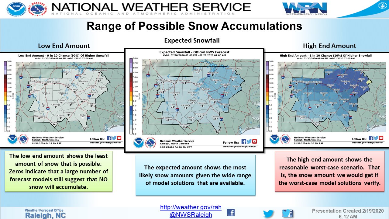
Ok, I know we don't want to discuss the decisions that every NWS station makes, but this tweet (6:22 am) is just plain wrong and misleading. Under the low end map it says:
"Zeros indicate that a large number of forecast models still suggest that NO snow will accumulate."
I don't think there is any model that show not accumulating snow for the entire Raleigh area is there?

"Zeros indicate that a large number of forecast models still suggest that NO snow will accumulate."
I don't think there is any model that show not accumulating snow for the entire Raleigh area is there?

Webberweather53
Meteorologist
Ok, I know we don't want to discuss the decisions that every NWS station makes, but this tweet is just plain wrong and misleading. Under the low end map it says:
"Zeros indicate that a large number of forecast models still suggest that NO snow will accumulate."
I don't think there is any model that show not accumulating snow for the entire Raleigh area is there?

Yeah at this point that's complete nonsense, it's definitely going to snow in Raleigh, the idea that there might be nothing is completely off the table.
BHS1975
Member
I have to say I strongly disagree with the NWS discussion on snowfall amounts. I understand they are playing it safe right now but their discussion about temperatures being an issue isn’t valid imo if you look at the best model for thermals in this range, the 3km.
Temps QUICKLY crash to 32 across areas as the moderate to heavy precip moves in on the 3km nam. It is the best model imo with thermal profiles inside 48 hours and the NWS has been burned many times in recent memory by ignoring it.
View attachment 35513
Once the event really gets going we have a large area of 30-32F temps.
View attachment 35514
Also regarding precip, the 3km NAM is forecasting close to an inch for the RDU to Wilson corridor and then 1-1.5” of qpf East of there. Assuming the NAM rain/snow line is correct, even an average 5:1 ratio as discussed would yield 4-5” for Raleigh to Wilson and 5-8” east of there. I think they’re making the mistake of looking at globals for thermal profiles, something they’ve done repeatedly over the years while seemingly ignoring the 3km NAM for some unknown reason.
I think there having flashbacks of when they forecasted several inches of snow and we got 40s and rain.
Sent from my iPhone using Tapatalk
New RGEM looked good, finally.IMO the model to follow is the 3km NAM and RGEM later today blended together. Everything has been trending to the overall NAM idea. Rgem caved, euro caved, and other models have too in recent days. The NAM and RGEM blend at 12z today should be pretty close to what actually happens. The 6z RGEM was a massive jump towards the NAM too with widespread 4-5” amounts and still snowing at the end of the run on pivotal.
Edit: I posted before reading all the posts. The RGEM has obviously been discussed. I am glad to see it and the Euro move onboard. Going to be tough fighting sleet, but that's the way it goes. But you sacrifice moisture for temps, I guess.
snowlover91
Member
I think there having flashbacks of when they forecasted several inches of snow and we got 40s and rain.
Sent from my iPhone using Tapatalk
Yep and they ignored the 3km NAM warm nose in that one and went with the globals. They’re doing the same here just in reverse.
Jessy89
Member
Upstate sc areas looks more like a quick blow to me. North of 85 Dusting to 2 inches. Amount depends on When it turns to snow. 2-6pm that’s maybe 4hrs the grounds warm it take time to stick. Any change over before 1-2pm would be good to see a decent event. I really feel this comes down to what time the changeover happens. Dusting to 2inches is my gut feeling on this one
Sent from my iPhone using Tapatalk
Sent from my iPhone using Tapatalk
Cadi40
Member
Definitely a little disappointed with the expected amounts here, however congrats to those forecasted for more..
iGrey_X
Member
The changeover is starting around 11-12 and likely will go until 8-10. Might want to up that some.Upstate sc areas looks more like a quick blow to me. North of 85 Dusting to 2 inches. Amount depends on When it turns to snow. 2-6pm that’s maybe 4hrs the grounds warm it take time to stick. Any change over before 1-2pm would be good to see a decent event. I really feel this comes down to what time the changeover happens. Dusting to 2inches is my gut feeling on this one
Sent from my iPhone using Tapatalk
Jessy89
Member
The changeover is starting around 11-12 and likely will go until 8-10. Might want to up that some.
I hope your right.
Sent from my iPhone using Tapatalk
Snownut
Member
Why are models showing Rain but soundings are showing snow where that rain is showing up? That has me confused.


