• Hello, please take a minute to check out our awesome content, contributed by the wonderful members of our community. We hope you'll add your own thoughts and opinions by making a free account!

Pattern February 11-13 2025

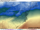
Some of the coldest wet weather you can get (..not being freezing rain). Still wondering if it'll trend just a little bit colder.

My Grid (looks like a Seattle forecast):
1739016697785.png
Roxboro:
1739016825037.png

From RAH:
Nuisance wintry p-type will be possible Mon morning and early Tues,
although the forecast is trending away from snow as point soundings
show a deep-isothermal layer around 0C and partial thicknesses
combined with surface temps would be more indicative of sleet.
Strength of the WAA will be much stronger for Tues morning and
likely result in an initial brief `burst` of sleet that quickly
transitions to rain. Accumulations of any kind would be most
probable near the VA/NC border both mornings, but likely be light
and/or limited given surface temps rising and moderate rain moving
into the region. As such, no impacts to wintry p-type are expected
at this time.
 
WBTV has Charlotte 7 day …. Next Tuesday it’s not even cold rain they have 90% Rain and 46/38 ??? What happen to the 33 and Rain? 46??


Sent from my iPhone using Tapatalk
 
1739048089983.png
NAM is gonna do its normal thing where it sends precip too far north because of WAA. This reminds me a lot of 1/5 and the NAM did this exact thing. As the system got closer it trended farther south to other modeling. Then of course the actual band came in south of modeling.1739048254792.png
 
RAH has switched from sleet to snow as the potential mix type:

.LONG TERM /MONDAY THROUGH SATURDAY/...
As of 247 PM Saturday...

* Potential for a cold air damming pattern as early as Monday
through Thursday.
* Periods of moderate rain likely Tuesday and Wednesday night.

A quick moving arctic high will push across the Ohio Valley into the
Mid-Atlantic region early Monday morning clearing rain out of the
region. Wintry p-type will be possible in the far NE CWA near the VA
border as the CAD set up begins
. By the afternoon much of the precip
is expected to be out of the area, but could linger near the coast.
Most of Monday evening and overnight is expected to be dry as the
surface high pushed off the DELMARVA coast and CAD conditions
redevelop across the region. Tuesday through Thursday night is
expected to be wet with multiple wave of precip moving across the
region. With the CAD conditions in place another burst of snow/rain
wintry mix is possible Tuesday morning across the northern Piedmont
.
While there is still some disagreement in how far south this snow
mix makes it into NC, the GFS brings cooler temps than the EURO
Tuesday morning. While confidence is low that it will be more snow
thank rain, a mix isn`t out of the question especially a few hours
along the VA border Tuesday morning. By mid morning temps will at
the surface and aloft are expected to warm enough that a change to
all rain is expected to continue through much of Thursday. Periods
of heavy rain are expected especially Tuesday and Wednesday with PWs
over 1 inch and healthy upper level moisture. After many frontal
passages move across the region, the final one will move out of the
region late Thursday night clearing the area of gloomy weather.
Friday the sun is expected to come out as high pressure extends from
the Northern Plains. Sunshine is not expected to last as it will
quickly progress across the country followed by another wave of
unsettling weather for the weekend.
 
I don't have a dog in this fight, but this looks like a classic front-end thump over-performer for whoever gets in on that initial fronto band that'll probably be relatively stationary Tuesday morning. It could be as far south as the Northern 1/3rd of NC. Thermal profiles look fine for all snow until that band lifts north of wherever it sets up.
 
I don't have a dog in this fight, but this looks like a classic front-end thump over-performer for whoever gets in on that initial fronto band that'll probably be relatively stationary Tuesday morning. It could be as far south as the Northern 1/3rd of NC. Thermal profiles look fine for all snow until that band lifts north of wherever it sets up.

I’d be pretty confident in that Hwy 421 Corridor in NC

Boone - N Wilksboro - Winston and North into VA …. I could see a scenario where the wanna be Cowboys up in Love Valley get in on the action too. It’s insane the distance Love Valley is from like Mooresville and still
In Iredell but it’s like 1400’ elevation up through there in spots

Sent from my iPhone using Tapatalk
 
Last edited:
20 miles and the 85 crew is in the game verbatim….850 wise


Sent from my iPhone using Tapatalk
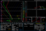
Problem is you have a raging warm nose between H85 and H7. Sounding in the coldest spot along NC/VA border at 15z Tuesday. Looking like the very definition of a nuisance event with several hours of sleet with temps just above freezing.

nam_2025020900_063_36.54--80.63.png

coltmpmax500.us_ma.png
 
Problem is you have a raging warm nose between H85 and H7. Sounding in the coldest spot along NC/VA border at 15z Tuesday. Looking like the very definition of a nuisance event with several hours of sleet with temps just above freezing.

View attachment 168087

View attachment 168086

Oh yea, I’m not expecting snow lol I just wanted some ice to look at some glazed trees while I was at work Tuesday


Sent from my iPhone using Tapatalk
 
Problem is you have a raging warm nose between H85 and H7. Sounding in the coldest spot along NC/VA border at 15z Tuesday. Looking like the very definition of a nuisance event with several hours of sleet with temps just above freezing.

View attachment 168087

View attachment 168086
Oof that is pretty nasty. Seems get warm nosed in the 700-850mb layer a lot, wish we had a 775 mb 0c line map or something. But also that map you posted works pretty well, too.
 
Oof that is pretty nasty. Seems get warm nosed in the 700-850mb layer a lot, wish we had a 775 mb 0c line map or something. But also that map you posted works pretty well, too.
My preferred method is partial thicknesses (1000-850 and 850-700). I'll pull out BUFKIT for those when things get serious, but the max column temp + soundings works in a pinch haha.
 
What the heck?! ABC11 in house model has a significant event for northern NC Tuesday morning. Only model I've seen like that. I guess it's the GRAF 🤷‍♂️. Can't find it online anywhere to share image
Yeah, I saw 2 different local channels that had snow/mix way far south of the Triad for Tuesday morning. I’m sure it will back off over the next 24 hours.
 
Yeah, I saw 2 different local channels that had snow/mix way far south of the Triad for Tuesday morning. I’m sure it will back off over the next 24 hours.
I'm thinking it will also but was a little surprised to see it. Had all frozen (sn to ip) north of I-40 but literally had Raleigh in it at onset
 
Pretty wild seeing almost 80F in central SC and sub 40F in central NC. I imagine after 2 days of heavy rain with temps in mid-30s we are going to be hoping for spring.


View attachment 168094

Never, anything over 60 is too hot… sure, I could lose some weight probably, but i absolutely despise weather here after Conference tourney weekend. Can i request 33 and heavy rain forever ? That way my wife can’t make me do stuff outside like go to parks with the kids, or yard work ect ? …. Also, not that this was ever , but new rule if I don’t see Notable posters from my area posting in here it’s not a “Real” threat, it’s being wishcasted. Myfro704 , Grit, WOW ect. Should be telling if none of those dudes care enough to show up


Sent from my iPhone using Tapatalk
 
NAM is definitely concerning but I’m going with my original thought process. It’s too far north and should correct south some with time
 
Back
Top