-
Hello, please take a minute to check out our awesome content, contributed by the wonderful members of our community. We hope you'll add your own thoughts and opinions by making a free account!
You are using an out of date browser. It may not display this or other websites correctly.
You should upgrade or use an alternative browser.
You should upgrade or use an alternative browser.

WolfpackHomer91
Member
The GRAPH model is absolutely out of control and can’t be contained … what in the world ? Did Burrell program this thing ? Lmao

Sent from my iPhone using Tapatalk
interestedclimatist
Member
The GRAPH model is absolutely out of control and can’t be contained … what in the world ? Did Burrell program this thing ? Lmao
Sent from my iPhone using Tapatalk
Nah it’s 100% accurate no cap
Welcome to the party GEFS

MichaelJ
Member
Until I see the thermals on the NAM in about 36 hours, I don't think we have a handle from the globals on p/types. NAM does terrible at range and tends to limit QPF but it's thermals are often dead on
packfan98
Moderator
The 18z Euro AI looks about the same to me. Maybe a hair worse?
I won't ever declare victory prematurely, but the only thing I will say is you just can't get locked into what you've seen on guidance in the D5-7 range. Sometimes what seems like a stone cold lock in that range turns out to be a mirage and that's where I was coming from yesterday. Appreciate the acknowledgement -- I've had my share of misses too -- and it's how we get better!@1300m sorry I doubted you here.
I died on the hill I was on
SnowNiner
Member
The GRAPH model is absolutely out of control and can’t be contained … what in the world ? Did Burrell program this thing ? Lmao
Sent from my iPhone using Tapatalk
I’m sorry, these GRAF models are pretty terrible. I can’t think of a storm this year where it was anywhere near accurate in precipitation or amount. IMO.
SimeonNC
Member
Do you still feel like the storm might end up being a CLT-RDU crush job like you mentioned it might be a couple days back?I won't ever declare victory prematurely, but the only thing I will say is you just can't get locked into what you've seen on guidance in the D5-7 range. Sometimes what seems like a stone cold lock in that range turns out to be a mirage and that's where I was coming from yesterday. Appreciate the acknowledgement -- I've had my share of misses too -- and it's how we get better!
I think we could still see some westward enhancement of the QPF field back towards CLT, but if we continue to see the H5 trends I discussed earlier, enhanced deformation banding would probably stay east of CLT and favor the RDU to northeastern NC / southeastern VA corridor for the greatest totals. In other words, I don't think CLT will jackpot, but a 2-4" type event is still in play there IMO.Do you still feel like the storm might end up being a CLT-RDU crush job like you mentioned it might be a couple days back?
Just to clarify, the increasing confluence over the NE is a good thing for our region, as that is working to move more pre-storm cold air to the south, which was and continues to be needed in order to inch closer to more snow and less mix.Well, catching up from last night, it seems like the drying up trends unfortunately continued, and may not be over yet. Pretty bummed the Euro and the EPS has dried up and caved to the AIs. I guess they win another one here.
Grit tried to warn us a while ago that the more confluence we get, the weaker the storm may be, and that's pretty much the situation I think. The monster -AO, and significant cold is making the southern energy weaker (until it gets in the ocean). Too much of a good thing I guess, again. It's actually too cold for the CLT area to snow this winter.
I don't buy into the more precip NW than modeled discussion, at least that will matter for mby. Reality for me is this is a Raleigh and NE storm, and perhaps an advisory event for MBY and west. We'll see. I'll take a couple of inches if I can get it, but I'd be shocked if I get more than 1 or 2 inches out of this at this point. I actually miss the runs where I was getting a couple inches of sleet and ZR. smh.
But what I had mentioned some days ago was that a weaker storm was possible if the precip was going to be based on the southern stream wave going on its own without NStream phasing.
Here we can see over the past 6 runs of the EPS that the southern stream wave has lost some of its amplitude (seen best thru MS and Bama), and the phasing that eventually occurs is late and closer to the east coast. The increasing confluence over the NE could be contributing a little, but it's odd because the western ridging is increasing. It's almost like the increased ridging is moving the NStream low east such that the southern stream wave isn't allowed to go negative tilt as much and sharpen, all the while not enough ridging to increase the phasing of the streams earlier.

But accordingly, the precip totals have been decreasing on the EPS, and the lighter precip on the Euro AI and Graphcast are red flags as well.

Couple things that I think can help Raleigh and eastern NC are: 1) The improving upper level jet structure (as SD and 1300 have mentioned), and 2) When the surface low moves out of the Gulf and hits the Gulf Stream off the GA and SC coast, it will likely slow down and bomb out a bit more than currently modeled as the modeling historically really struggles to fully capture the dynamics in that area - this is especially true because the trailing NStream low / wave that is dropping in isn't moving at a fast rate, so the low isn't going to sweep out to sea quickly


iwantsouthernsnow123
Member
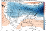
This is exactly what leads me to believe that we may not have this system figured out until 24 hours at least.. Maybe not even until the event itself arrives.. This specific frame is 25 hours out, 1 day. 500mb vort had a huge shift there. There's so much to figure out with this system and the smallest changes in the 500mb levels can result in substantial changes.
Attachments
NCHighCountryWX
Member
- Joined
- Dec 28, 2016
- Messages
- 700
- Reaction score
- 1,921
What models are this, and which runs?
NBAcentel
Member
This looks like a carbon copy to the vort that produced clipper snow east of the mountains back in Dec. I bet hi res models and CAMs will be excited under this 
WolfpackHomer91
Member
probably means nothing since He’s a Yankee …. But, it’s 8:47 nothing going on in here in between cycles. So here
Sent from my iPhone using Tapatalk
Sent from my iPhone using Tapatalk
NBAcentel
Member
Hrrr is gonna begin to get in range around this time tomorrow 
Blue_Ridge_Escarpment
Member
Looks pretty NAM likeHrrr is gonna begin to get in range around this time tomorrow View attachment 169816
rburrel2
Member
As far as the non-coastal precip that's slowly drying up on modeling... I just want to point out that most models had nothing with that last Coastal scraper storm in this time range, and they all came back with a little better WAA/overrunning precip.
As it stands now, every model is giving us at least around 1/10th inch of liquid with some as much as 3/10ths.
If we can trend the southern wave a little better in the final 60hrs we can absolutely get a widespread 2-4 incher for a wide swath (Northern AL/GA/SC, and Western and Central NC.
And that doesn't have anything to do with the coastal development.
I'll be shocked if it trends much drier than where we're at now, just my two cents.
It did pretty well with the early January clipper and was the only model to predict that precipitation would get into Central NC while everything else stayed dryI’m sorry, these GRAF models are pretty terrible. I can’t think of a storm this year where it was anywhere near accurate in precipitation or amount. IMO.
It did poorly with the thermals on the last system though
I mean, Richmond is still 6-8” on the 18z Euro by my look at it.Not really, the trend has not slowed down at all, what’s stopping it? Richmond was the jackpot yesterday now they are eating cirrus almost and that’s a day ago! Another day of trends like this and it’s down to new Bern and hatteras
rburrel2
Member
21z SREF is finally moving a little south compared to the ridiculous runs, but it's still a qpf bomb compared to everything else.
It would be nice to get some proper NAMing's while it shifts down from the amped solution. It will probably going from all rain to nothing in one run though just because.

It would be nice to get some proper NAMing's while it shifts down from the amped solution. It will probably going from all rain to nothing in one run though just because.
Sometimes you have to wonder if it's the model that sucks, or just the ptype algorithms used in the software that displays them. I've seen some bogus stuff on WeatherBell already with this system when comparing to soundings.It did pretty well with the early January clipper and was the only model to predict that precipitation would get into Central NC while everything else stayed dry
It did poorly with the thermals on the last system though
NBAcentel
Member
Thats my thinking. Maybe some more lower QPF runs tonight, then we start the other direction tomorrow-Tuesday. Even the gulf mauler had that last second upward QPF trends mainly because models started to recognize the jet streak aloft and were to dry in the low levels. Low levels aren’t gonna be this dry to start out this go around that we have to fight. And the overrunning precip before the main coastal is driven by warm air advectionAs far as the non-coastal precip that's slowly drying up on modeling... I just want to point out that most models had nothing with that last Coastal scraper storm in this time range, and they all came back with a little better WAA/overrunning precip.
As it stands now, every model is giving us at least around 1/10th inch of liquid with some as much as 3/10ths.
If we can trend the southern wave a little better in the final 60hrs we can absolutely get a widespread 2-4 incher for a wide swath (Northern AL/GA/SC, and Western and Central NC.
And that doesn't have anything to do with the coastal development.
I'll be shocked if it trends much drier than where we're at now, just my two cents.
- Joined
- Jan 2, 2017
- Messages
- 1,566
- Reaction score
- 4,279
Wisdom teeth extraction Wednesday morning down in anderson...not looking forward to it at all. But to see some flakes during the morning drive would sure be nice.
Id expect some interesting model runs by the hi-res models tomorrow. Then we will watch a whole new set of trends through tuesday.
Id expect some interesting model runs by the hi-res models tomorrow. Then we will watch a whole new set of trends through tuesday.
WolfpackHomer91
Member
21z SREF is finally moving a little south compared to the ridiculous runs, but it's still a qpf bomb compared to everything else.
It would be nice to get some proper NAMing's while it shifts down from the amped solution. It will probably going from all rain to nothing in one run though just because.
View attachment 169819
Whole State .5” QPF + …. I will take it
Sent from my iPhone using Tapatalk
NBAcentel
Member
NAM starting to do the squash thing to. Probably gonna start going to consensus
rburrel2
Member
Yep, these trends the last two'ish days have been great for cold air entrenchment... but there's little chance that trend continues for two additional days. You know good and well we will get height rises in the SE on the models in the final 48 hrs. You can pretty much set your clock to it.Thats my thinking. Maybe some more lower QPF runs tonight, then we start the other direction tomorrow-Tuesday. Even the gulf mauler had that last second upward QPF trends mainly because models started to recognize the jet streak aloft and were to dry in the low levels. Low levels aren’t gonna be this dry to start out this go around that we have to fight. And the overrunning precip before the main coastal is driven by warm air advection
Stormlover
Member

From Meteorologist Chris Nunley
Stormlover
Member
it's trashNAM starting to do the squash thing to. Probably gonna start going to consensus
Probably foretells the 00z NAM shifting south tonight, which it almost has to, LOL.21z SREF is finally moving a little south compared to the ridiculous runs, but it's still a qpf bomb compared to everything else.
It would be nice to get some proper NAMing's while it shifts down from the amped solution. It will probably going from all rain to nothing in one run though just because.
View attachment 169819
SnowNiner
Member
Whole State .5” QPF + …. I will take it
Sent from my iPhone using Tapatalk
Sref is worse than the graf. But we’ve got those 2 in our corner baby!! lol. I need to stop. I’m going to appreciate the mood flakes on Wednesday.
I’d feel better about it if Gatlinburg was going to get a storm as I’m heading there Friday. But they’re not going to get much either. I tried to tell our group that Gatlinburg is not real mountains and we should have went to Boone, Blowing Rock. Lol
Cary_Snow95
Member

NBAcentel
Member

Chattownsnow
Member
Just look at what the NAM was doing with the coastal in Maine at HR 69 compared to HR 3. It had duel lows with a secondary off the coast and that’s completely changed to a single low off the coast with the secondary (really primary according to the model) completely gone all together. Model is garbage. Needs to be retired 

It works great within 12 hrs or so.Just look at what the NAM was doing with the coastal in Maine at hour 69 compared to current OBS. It had duel lows with a secondary off the coast and that’s completely changed to a single low off the coast with the secondary (really primary according to the model) completely gone all together. Model is garbage. Needs to be retired View attachment 169825View attachment 169826
jay.p
Member
Works even better if it shows rain at your house at any point in its 84 hour runIt works great within 12 hrs or so.
Chattownsnow
Member
In that case it will nail this storm for me lolWorks even better if it shows rain at your house at any point in its 84 hour run
Cary_Snow95
Member