wow
Member
Canadian came in less amped and further south vs 0z, thus colder
Yep, holds for Western areas it seemslooks like the 925 gets eroded away between hrs 105 and 117


Which model is this?It’s a doozy at this lead View attachment 169215View attachment 169216
Which model is this?

Yeah I like colder trends but I'm also not convinced if this is more amped, we don't lose it completely ro our NW. If my outcome is either mega zr or rain, give me rain all dayUK has the SLP was inland at 12z...from the crude maps. yikes
This will be one of those few storms we will be studying the 925 trends and not the 850. In my experience, it will be harder to predict up until go time, although the NAM may actually be helpful for once with this.Yep, holds for Western areas it seems View attachment 169220
UK has the SLP was inland at 12z...from the crude maps. yikes
It has already started. And it’s right on timeUK has the SLP was inland at 12z...from the crude maps. yikes

Exact trend that excites low level/surface cold but excites warmth in the upper low levels.. yikesIt has already started. And it’s right on time View attachment 169222
Looks euro esqueThat's pretty ugly...I guess would be good for those in Raleigh that don't want an ice event.
View attachment 169223

I know it's the ops run but that's a rotten LP track for RDU. Need it ~75 miles se or least less amped 1010 vs 1003 maybe?Looks euro esque View attachment 169224
That even looks bad for D.C.That's pretty ugly...I guess would be good for those in Raleigh that don't want an ice event.
View attachment 169223
What's that about the UK and euro lining up? Hard to beat?That's pretty ugly...I guess would be good for those in Raleigh that don't want an ice event.
View attachment 169223
What's that about the UK and euro lining up? Hard to beat?


Yeah but didn't originally apply to UK and euro I believe. Navy model or somethingEE Rule
Sent from my iPhone using Tapatalk
I am just a hobbyist that has been interested in the weather since I was a kid but I would lean towards more freezing rain than sleet at this point for the RDU area. There is still plenty of time for things to change between now and Wednesday but I would start preparing for an extended period without power and tree damage in your yard. There are several meteorlogists here who have a much better grasp on the specifics than I do so I would keep an eye on things and hope for the best. As far as ice accrural totals I would lean towards the 1/2 inch mark or potentially higher at this point.So if I’m seeing this right it’s looking like a wintry mix for the RDU area. This wintry mix will likely include more freezing rain and sleet. The freezing rain will be around a quarter to half an inch. Is that right?
I loved what the Canadian showed, mostly sleet from N. Charlotte - threw RDU - up to the northern Coastal plain.Big dropoff in precip for the 12z Canadian vs last night's run.
View attachment 169221
View attachment 169217


You are good. The TRIAD will ALWAYS find a way to score big12z Ukmet snowing good Triad. Beaut
Me too, just wish it were the gefs and/or epsI loved what the Canadian showed, mostly sleet from N. Charlotte - threw RDU - up to the northern Coastal plain.
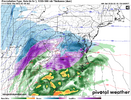
Still a big storm elsewhere in NC. Pivotal maps don't delineate between freezing rain and sleet.12z Ukmet snowing good Triad. Beaut
But that's after this falls:


Ends up about 5-7 snow, sleet accumulating.You are good. The TRIAD will ALWAYS find a way to score big


.thumb.png.142042860796e27647bd9c66218556db.png")