Bigedd09
Member
Alright ya'll in Eastern NC don't get mad if areas back west see a 3-4 incher by the end of snow season. Ya'll got yours and overperforming today lol
theyre so big but so fluffy, i can see straight through them as they pile down from the sky right now. total snowglobe.Back to heavy snow. Man I'm not far from 5" total now. This last bit of snow is pure fluff:
View attachment 171120
I think you all have more on the roads than we did since you all got more of your snow in the late afternoon and after dark.Here’s a picture of Hillsborough street in Raleigh around 10 am.
View attachment 171118
That late February sun don't play.Sun is zapping everything away
Gosh, I’m jealous. Further north always wins around here lol. It’s just been light snow here. Nice to look at but not going to add up to anything and the roads are melting off while the snow falls.Back to heavy snow. Man I'm not far from 5" total now. This last bit of snow is pure fluff:
View attachment 171120

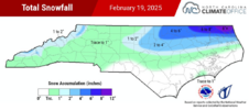
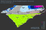
we all need to pour one out for the dry slots in NC that simply could not pull it together to bank anything from this event - looks like some spots NE of CLT, and then the Hickory-ish area too? and of course the lower SE section of the state near the beaches, but that was expected.Preliminary 72-hour snowfall from the NOHRSC as of 7am this morning, and season-to-date totals.
Impressive footprint with this most recent system. Central MS still waiting on their storm, not sure they get it but I'll be rooting for them.
View attachment 171123
View attachment 171125
Don't worry a repeat of March 1927 is coming in a week or two.we all need to pour one out for the dry slots in NC that simply could not pull it together to bank anything from this event - looks like some spots NE of CLT, and then the Hickory-ish area too? and of course the lower SE section of the state near the beaches, but that was expected.
It’s like Usain Bolt fastSun is zapping everything away


Think I hit on pretty much all of these, except slightly too low IMBY (should’ve went 2-4” like my weenie self wanted to lol), and I think I might’ve been low in PGV (they got very little snow but I think they might’ve ended up over 3” in sleet alone). I think RIC barely made 3”.I sometimes wonder if there’s some positives to that, like so it’s not overreacting to small changes that end up being inconsequential in the end. I don’t know.
Anyways, time for my terrible final call.
CLT: T-0.5”
GSO: 0.5-1.5”
NE Chapel Hill (MBY): 1-3”
Durham: 2-4”
RDU: 2-4”
PGV: 1-3”
@RBR71: 4-8”
Moyock: 8-12” (could be higher, but it’s hard to snow that much and compaction may cut totals)
ORF: 8-12”
RIC: 3-6”
Think I hit on pretty much all of these, except slightly too low IMBY (should’ve went 2-4” like my weenie self wanted to lol), and I think I might’ve been low in PGV (they got very little snow but I think they might’ve ended up over 3” in sleet alone). I think RIC barely made 3”.


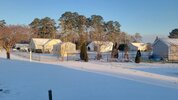
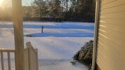
The irony is that you probably had a much higher impact event than us further west. That sleet is going to be much harder to melt! 3” of sleet is serious! I don’t think I’ve ever gotten more than 2” of it.Hard to tell how much we got but 3" is a safe bet all sleet here but in town they probably pulled a .5-1" of snow yesterday when it flipped for a hr.
View attachment 171135
View attachment 171136
