That’s one heck of a inversion


I see they also added one more county to the east (literally just one county, Warren) and now have me with a HWO.... #winningGood write-up from NWS Raleigh:
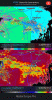
A strong and cold 1040 hPa high pressure system centered across
the eastern Great Lakes this afternoon will move into eastern
NY/PA tonight and weakens as it reaches the New England coast
late Wednesday. The high is of sufficient strength and in a
favorable location to establish a CAD regime tonight that will
extend into Thursday. Dry air has extended south with surface
dew points in the single digits across NY, the teens in PA into
northern VA and the 20s across northeastern NC. A strong upper
level trough near the four corners region this afternoon will
move into the Central Plains as a strong southwesters flow
aloft extends across the southern Plains and Southeast. In
addition, a strengthening low and mid level southerly flow will
provide ascent and moisture resulting in lowering ceilings and
this afternoon as precipitation expands and develops across the
area.
Latest NWP guidance suggests that the amount of cold and dry air
at the surface may be more limited than previous forecast
guidance. This is seen in a dprog/dt of NAM surface T and Td. A
band of light precipitation driven by mid level warm advection
continues to stream east across our southern tier. This
precipitation is being driven by elevated processes and the
precipitation is falling out of elevated ceilings of 8kft or
higher resulting in lots of virga and spotty amounts. Expect
some sleet to mix in at times this afternoon and early evening,
mainly at the onset as the precip cools into the dry air below
the cloud deck.
Isentropic lift ramps up this evening in the 295 to 300K layer
resulting in a region of low and mid level ascent and subsequent
warm advection precipitation. The precipitation will overspread
the region from southwest to northeast this evening and
overnight. Although the forecast BL temps may have warmed,
forecast soundings suggest a burst or brief period of wet snow
and sleet will mix in with the rain this evening across the
Triad and then spread northeast into the VA border counties. The
snow and sleet should be short lived and will fall with surface
temperatures above freezing resulting in limited accumulations.
Given the rates may be impressive for a short period, have
added a limited coating of snow/sleet to the forecast in these
areas. A strong southwest flow aloft will push a strong warm
nose across the area shutting down the snow potential quickly
this evening.
The precipitation will produce some wet bulb cooling as the surface
layer becomes saturated. Not surprisingly the NAM is the
coolest guidance with the wet bulb freezing line pushing south
into the I-85 corridor which should serve as the farthest
extent of any freezing rain potential. The GFS is notably warmer
in the surface layer and partials. Will lean toward the cooler
NAM solution given its skill to handle these patterns more
skillfully. This will support a changeover from rain to freezing
rain as temperatures fall to 32 or 31 in the damming region
after several hours after midnight from Albemarle to Raleigh to
Warrenton northwestward. Given the marginal surface
temperatures, the light precipitation amounts, some lulls in the
precipitation and moderate temperatures ahead of the event,
expect ice accumulations will be limited and mainly confined to
locations near and north of I-85 where a light glaze is possible
with radial ice accumulations of 0.08 inches or less.
Temperatures will slowly moderate after daybreak on Wednesday as
the parent high pressure system moves away. This will allow the
freezing rain to diminish from south to north and end during
the mid morning hours. Lows will range in the 30 to 32 range in
the northern Piedmont and the mid 30s elsewhere.

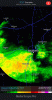
Would be nice if it could defy the odds and give me some token flakes.... all rain here in the upstate.Watching this rouge monster approach is too much fun .. models aren’t seeing this AT ALL crazy that this storm is defying any odds put against it .. plus thunder later along with the band .... you know what that means in 10 days ??

Not verifying IMBYView attachment 16021