I hope it's not like the time I saw my grandma naked.Just one more of that and something that can’t be unseen will be seen
-
Hello, please take a minute to check out our awesome content, contributed by the wonderful members of our community. We hope you'll add your own thoughts and opinions by making a free account!
You are using an out of date browser. It may not display this or other websites correctly.
You should upgrade or use an alternative browser.
You should upgrade or use an alternative browser.
Misc Winter Weather Support Group
- Thread starter RBR71
- Start date
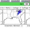
Icon is the worst model in the history of models! Think the DGEX even has higher verification! ?
Get your roof rake! Roof crusher incoming…I trust your extrapolations. How many inches in upstate SC? Western shield underdone?
Yes...I trust your extrapolations. How many inches in upstate SC? Western shield underdone?
In that setup places East of 77 are in Heaven.
Places East of 26 are in glory.
Places NW of 85 West of 26 get shafted again.
Of course it's just run 1 of 1 model but,
It's exactly what happened during the Carolina Crusher.
It definitely crushed my soul....
Well onto the 12z and would like to see 0z favorable trends resume at that time. Also not just the I"CON"
GFS & ensembles off to a bad start to kick start Tuesday.
Last night was pretty good. Even Canadian was a beast and like a half a degree at surface from crushing several folks. Its waking up to the 6z GFS suite that's serving sour pickle juice for coffeeI see I didn’t miss anything going to bed early last night. I should do it more often.
Webberweather53
Meteorologist
This one feels like it’s over.
Twister
Member
It was over from the start. It was just never looking cold enough. You can't get a winter Storm without a legit cold sourceThis one feels like it’s over.
Sent from my SM-S911U using Tapatalk
I'm glad someone else said itThis one feels like it’s over.
It was a little more than a week out. Plenty of time for it to happen. ICON could have been on to something last night.
Brick?It was a little more than a week out. Plenty of time for it to happen. ICON could have been on to something last night.
What do we have to lose?I guess we really are throwing all our chips on the table for mid feb.
Correct. Good thing is this is it. Either that 2 week period produces or it doesn't. No more can kicking. Either you get snow or you move onI guess we really are throwing all our chips on the table for mid feb.
Twister
Member
Then you will be throwing them all on table for end of Feb. Then The Flowers and Trees will be blooming and everyone will be wondering what happened this winter. People needs to realize that things are Changing and Winters around here are not like they use to be. After all this is the South and Winters storms are hard to come by Anyways. Everything has to be absolutely perfect and that these days are hard pressed!I guess we really are throwing all our chips on the table for mid feb.
Sent from my SM-S911U using Tapatalk
That's the real fear is that this is the new normal. It'll snow here again for sure. And probably be some good snows. But those years of a decent storm plus a couple smaller events, plus several near misses made for good times. It's been very boring for years now outside Jan 22 and who knows if those times will return anytime soon.Then you will be throwing them all on table for end of Feb. Then The Flowers and Trees will be blooming and everyone will be wondering what happened this winter. People needs to realize that things are Changing and Winters around here are not like they use to be. After all this is the South and Winters storms are hard to come by Anyways. Everything has to be absolutely perfect and that these days are hard pressed!
Sent from my SM-S911U using Tapatalk
Then you will be throwing them all on table for end of Feb. Then The Flowers and Trees will be blooming and everyone will be wondering what happened this winter. People needs to realize that things are Changing and Winters around here are not like they use to be. After all this is the South and Winters storms are hard to come by Anyways. Everything has to be absolutely perfect and that these days are hard pressed!
Sent from my SM-S911U using Tapatalk
That's the real fear is that this is the new normal. It'll snow here again for sure. And probably be some good snows. But those years of a decent storm plus a couple smaller events, plus several near misses made for good times. It's been very boring for years now outside Jan 22 and who knows if those times will return anytime soon.

Iceagewhereartthou
Member
Just one OP run but GFS shows no widespread freeze outside of elevation through mid Feb. If that verified it would take a pretty historical turn the second half to bring anything outside the mountains; thats pretty late to be reshuffling the pattern. Of course it could look totally different next run but our can kicking can only go on so long. Tough stretch we're on.
Twister
Member
No it's called being realistic
Sent from my SM-S911U using Tapatalk
So, is it too early to talk of the days of March 1960 lore?
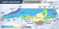
When is the last time Raleigh had 6 inches of snow in total for winter, and the last time they had more than 6 inches from a single storm?
BHS1975
Member
The snow climate has shifted way north. I think we got the climate of what CAE used to be.
Sent from my iPhone using Tapatalk
Sent from my iPhone using Tapatalk
When is the last time Raleigh had 6 inches of snow in total for winter, and the last time they had more than 6 inches from a single storm?
2018 probably
Could be worse. IIRC this time in 2009 we were mourning the death of Groundhogzilla. For several days all the globals were converging on a massive winter storm, and it hadn't been since 1993 that the globals were in such good agreement 4-7 days out. As the 12z runs came out, it was utter disbelief as the GFS went poof. That was intitially dismissed as a fluke run, like whatever goofy. Then the 12z Canadian went poof. Uh-oh, what's going on here. Then the UK went poof. Oh no. Finally our worst fears were realized when the 12z Euro went poof. Any hope that it was simply a data ingest issue died with the following 0z runs. Our big daddy beast of a modeled winter storm had died a sudden tragic death. Those were some rough times.
The way you described that got me all choked upCould be worse. IIRC this time in 2009 we were mourning the death of Groundhogzilla. For several days all the globals were converging on a massive winter storm, and it hadn't been since 1993 that the globals were in such good agreement 4-7 days out. As the 12z runs came out, it was utter disbelief as the GFS went poof. That was intitially dismissed as a fluke run, like whatever goofy. Then the 12z Canadian went poof. Uh-oh, what's going on here. Then the UK went poof. Oh no. Finally our worst fears were realized when the 12z Euro went poof. Any hope that it was simply a data ingest issue died with the following 0z runs. Our big daddy beast of a modeled winter storm had died a sudden tragic death. Those were some rough times.
Imma CFS guy myself, fgreat mogel ...


SnowNiner
Member
Just need to go back to classic CAD. Even with a storm to the south, it's still really hard without it.
LukeBarrette
im north of 90% of people on here so yeah
Meteorology Student
Member
2024 Supporter
2017-2023 Supporter
Me do not like system, perhaps move on yes!?
There better be 20 new pages on the Feb thread for me to read while taking my dump tomorrow morning.
How did this work out?
- Joined
- Jan 5, 2017
- Messages
- 3,769
- Reaction score
- 5,966
RIPCould be worse. IIRC this time in 2009 we were mourning the death of Groundhogzilla. For several days all the globals were converging on a massive winter storm, and it hadn't been since 1993 that the globals were in such good agreement 4-7 days out. As the 12z runs came out, it was utter disbelief as the GFS went poof. That was intitially dismissed as a fluke run, like whatever goofy. Then the 12z Canadian went poof. Uh-oh, what's going on here. Then the UK went poof. Oh no. Finally our worst fears were realized when the 12z Euro went poof. Any hope that it was simply a data ingest issue died with the following 0z runs. Our big daddy beast of a modeled winter storm had died a sudden tragic death. Those were some rough times.
- Joined
- Jan 5, 2017
- Messages
- 3,769
- Reaction score
- 5,966
knise wurkk bump kitty.Imma CFS guy myself, fgreat mogel ...

EastNcHeel
Member
Congrats Bakersfield, CA. I've been pulling for yall.?Imma CFS guy myself, fgreat mogel ...

It's a shame to be so close yet so far away. Another one slipping through our fingers our winters have turned into the early 90s buffalo bills and global warming is the cowboys
What happened? You were so optimistic a few days ago on the winter? I lost my optimism 2 weeks ago ?It's a shame to be so close yet so far away. Another one slipping through our fingers our winters have turned into the early 90s buffalo bills and global warming is the cowboys


