packfan98
Moderator
They get together at hr 256 and goes boom in Atl.Gets a little disjointed with two areas of precip too close together.
They get together at hr 256 and goes boom in Atl.Gets a little disjointed with two areas of precip too close together.
hard not to get a lil excited on this because of how GFS had been the one main model holding out on a big NC storm, and.... 18z they were just like "nvm, hold my beer"
BOOM
Sent from my iPhone using Tapatalk
Late phase nukes ENC. beautiful look at this lead time View attachment 168757View attachment 168758View attachment 168759
Bro I swear I think we posted same time, check banter threadBro cash the check & let’s rage.
Sorry mods
Well dang looks like Virginia gonna miss out for the most part. Lol Still a ways to go but the trend looks further and further south.
saw the latest GFS spread into SC like that, and i was like "well good, mitch deserves a real snow finally!" lol lets hope it holdsBro cash the check & let’s rage.
Sorry mods
Usually is a NW trend with 2 days to go. I know people in the deep south want snow but we have not had a decent one up here in Virginia in 4 years. I am still running below average on snow this year. Past 3 winters have sucked, this one has been better but still not like winters of the past. Too much ICE! Pretty sure much of Louisiana has had more snow than me and TexasIt’ll probably trend back north but that’s my opinion
Sent from my iPhone using Tapatalk


Much further south, colder, further offshore surface low track from the gulf to off the SE coast. Slider/miller A flavor
Sent from my iPhone using Tapatalk
Usually is a NW trend with 2 days to go. I know people in the deep south want snow but we have not had a decent one up here in Virginia in 4 years. I am still running below average on snow this year. Past 3 winters have sucked, this one has been better but still not like winters of the past. Too much ICE! Pretty sure much of Louisiana has had more snow than me and Texas
did you not get a good few inches just earlier this week? i thought your area got some solid snow, but maybe Wytheville is a little too far south from the snow pockets of that storm and got mostly ice?Usually is a NW trend with 2 days to go. I know people in the deep south want snow but we have not had a decent one up here in Virginia in 4 years. I am still running below average on snow this year. Past 3 winters have sucked, this one has been better but still not like winters of the past. Too much ICE! Pretty sure much of Louisiana has had more snow than me and Texas
Well, at least one of you posted in the right place! 50% ain't so bad around here.Bro I swear I think we posted same time, check banter thread
SE Wake Co jackpot!Late phase nukes ENC. beautiful look at this lead time View attachment 168757View attachment 168758View attachment 168759
Northern VA certainly has had plenty and so has far SWVA its central VA and Richmond and Hampton Roads lacking. Also central NC basically.I understand that when the gulf coast storm was coming many people wanted it to hit NC and areas north like they don’t get snow already
Sent from my iPhone using Tapatalk
Ice lots of Ice. We did get around 4 but it was gone in 24 hours. Areas to our east got slammed hard with Ice. I warmed up to 33 yesterday and the rain melted it all.did you not get a good few inches just earlier this week? i thought your area got some solid snow, but maybe Wytheville is a little too far south from the snow pockets of that storm and got mostly ice?
RC I’d kill to be where you are now. Give it a few days when that ridge starts to amplify off the Atlantic.SE Wake Co jackpot!
Northern VA certainly has had plenty and so has far SWVA its central VA and Richmond and Hampton Roads lacking. Also central NC basically.
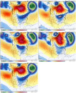
That press between 12z and 18z is impressiveGefs following its OP. More consolidated TPV near the lakes = slower exit into the ATL thus holding more confluence and influencing a lower height field beyond this point = storm lower in lower latitude in a mean sense View attachment 168761
I'll take this!Late phase nukes ENC. beautiful look at this lead time View attachment 168757View attachment 168758View attachment 168759
Well, it beats being on the rain/ice line at least. Baby stepsI hate to be Debbie Downer here but you do NOT want to be in the bullseye this far out, especially on the notoriously bad GFS
Bro cash the check & let’s rage.
Sorry mods
Yeah Fro, keeping that TPV appendage from backing into Bozeman and moving it east across the Great Lakes is the key move we need to get the CCAC group more involved - the climatologically cold air challenged (* raises hand)Gefs following its OP. More consolidated TPV near the lakes = slower exit into the ATL thus holding more confluence and influencing a lower height field beyond this point = storm lower in lower latitude in a mean sense View attachment 168761
This ridge is really flexing it's muscle in recent runs.I'll admit, I didn't think the EPS would have trended colder + wetter given the H5 look. That block is putting in extra effort apparently.
View attachment 168715

