-
Hello, please take a minute to check out our awesome content, contributed by the wonderful members of our community. We hope you'll add your own thoughts and opinions by making a free account!
You are using an out of date browser. It may not display this or other websites correctly.
You should upgrade or use an alternative browser.
You should upgrade or use an alternative browser.
Pattern Fab-February 2020 The dark age
- Thread starter Ilovesnow28
- Start date


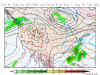
After looking through each model run, the key to getting snow in the SE will be to have this wave coming down from Canada (in purple) be stronger. That will pull SW energy into East. This is a small detail, but other models are on the side of a weaker wave, so I’m going with that. Nonetheless this can change easily.


Webberweather53
Meteorologist
The differences between the most recent 0z and yesterday's 12z Euro run are pretty trivial in a general sense for being 7-8 days out, don't become too overwhelmed & concerned w/ details (i.e. snow output), the signal for a storm is generally still there. This EPS suite however is not impressive at all and that's much more meaningful.
NBAcentel
Member
Gefs is mighty impressive 

Jon
Member
After looking through each model run, the key to getting snow in the SE will be to have this wave coming down from Canada (in purple) be stronger. That will pull SW energy into East. This is a small detail, but other models are on the side of a weaker wave, so I’m going with that. Nonetheless this can change easily.
View attachment 34228View attachment 34229View attachment 34230
That helps, but it may more to do with the feature just north of cali stretching to Washington state. That energy has been on the modeling that leaves the ULL out west. The stronger that is and more west it is, the less likely the northern stream can take it with it. It may be a combination of the two, but the GFS model run a few days ago without the energy feature west was still snow here
Sent from my iPhone using Tapatalk
ForsythSnow
Moderator
The real question is how'd the EPS as a whole look? If it completely threw it away then there's something to worry about.
The real question is how'd the EPS as a whole look? If it completely threw it away then there's something to worry about.
It didn’t completely throw it away, but is much worse.

Sent from my iPhone using Tapatalk
The EPS and models will change, setup is STILL there everyone.. Stay Calm!!It didn’t completely throw it away, but is much worse.

Sent from my iPhone using Tapatalk
It will be interesting to see which way the ENS (and op) go today. The EPS really was flat out bad. Are we going to find a way to mess this up already? Lol
Jon
Member
It didn’t completely throw it away, but is much worse.
Sent from my iPhone using Tapatalk
Ollie,
Do you have the last 3 runs of the EPS 500mb vorticity centered on 12z 2/21? I don’t have access to those maps. I would appreciate it!
Sent from my iPhone using Tapatalk
snowlover91
Member
It’s only one bad run of the Euro and EPS but they are the models you want on your side for a snow chance... we are getting inside 144 hours which is the Euro bread and butter range. Key for me is the ensemble support, you want better eps support than what we have right now to feel good about this. Still plenty of time for things to change but we took a step back last night with the Euro.
B
Brick Tamland
Guest
I see the back and forth dance and flip flopping with the models has begun. This is typical. We see this all the time when we have a winter storm threat. Yesterday the Euro was the first to show the storm, while the GFS and GEFS showed nothing, and the last run of the Euro showed less, while the GEFS jumped on board last time and shows a storm. Very rarely do we have a storm show up on the models and stay there the whole way, and very rarely does a storm show up on the models at the same time this far out. The back and forth and flip flopping at this time is a good thing in my opinion. It happens more often than not when we have a legit threat for a winter storm here. It is hard to get a storm here, and it is hard for the models to get a hold of one this far out. Heck, sometimes they do this dance until we get inside 48 hours. As long as at least one of them shows something this far out we still have a threat. Just have to wait and see how things go and how they sort things out now. Sometimes they have to get through all the noise to show what eventually will really happen.
Jon
Member
I see the back and forth dance and flip flopping with the models has begun. This is typical. We see this all the time when we have a winter storm threat. Yesterday the Euro was the first to show the storm, while the GFS and GEFS showed nothing, and the last run of the Euro showed less, while the GEFS jumped on board last time and shows a storm. Very rarely do we have a storm show up on the models and stay there the whole way, and very rarely does a storm show up on the models at the same time this far out. The back and forth and flip flopping at this time is a good thing in my opinion. It happens more often than not when we have a legit threat for a winter storm here. It is hard to get a storm here, and it is hard for the models to get a hold of one this far out. Heck, sometimes they do this dance until we get inside 48 hours. As long as at least one of them shows something this far out we still have a threat. Just have to wait and see how things go and how they sort things out now. Sometimes they have to get through all the noise to show what eventually will really happen.
The op GFS was the first one to find the storm, not the euro. The euro found in a full day or so later. Then the GFS IMMEDIATELY backtracked with the next run and said the ULL would be left out west and the NS energy will be too progressive. Then the Euro continued to show a nice solution, with no ULL. Until 12z yesterday, some separation started to occur, and with 00z today was even more.
The euro is clearly trending toward the GFS and they’re actually in more agreement today than they were yesterday.
Just because the euro Op has “something” this run doesn’t mean it will at 12z...the trend is obvious unless this is a big goof by the euro.
We have had big storms show up and stay on the modeling, I don’t think Dec 2018 gave us too much trouble and kept showing up solidly on the means.
But I agree with you about the noise. It could be just too much for the models to hone in on, but it seems they are moving toward a shared solution that leaves the SE out of a nice system.
Sent from my iPhone using Tapatalk
Jessy89
Member
Bottom line if Euro doesn’t trend better today. That won’t be a good sign. The chances of it getting squashed are high.
Sent from my iPhone using Tapatalk
Sent from my iPhone using Tapatalk
BHS1975
Member
Bottom line if Euro doesn’t trend better today. That won’t be a good sign. The chances of it getting squashed are high.
Sent from my iPhone using Tapatalk
I’d rather see that at this point and take my chances instead of a big jump north cause that would be a lock.
Sent from my iPhone using Tapatalk
B
Brick Tamland
Guest
I'd like to see some actual consistency with the models for at least two days to consider anything a trend. And even then they could change again. There is plenty of time for more back and forth with what the models show.
Last edited by a moderator:
Shaggy
Member
I'd like to see some actual consistency with the models for at least two days to consider anything a trend. And even then they could change again. There is plenty of time for m.k ore back and forth with what the models show.
Like I said yesterday, consistency and agreement are what's needed and right now both are shaky. That was euro run #3 only 13 or so more to go.
Much better this run IMO.Ollie,
Do you have the last 3 runs of the EPS 500mb vorticity centered on 12z 2/21? I don’t have access to those maps. I would appreciate it!
Sent from my iPhone using Tapatalk
06z

00z

18z

Two-run trend at 144Much better this run IMO.
06z
00z
18z
06z

00z

B
Brick Tamland
Guest
There is a specific thread for next week's potential storm.
Wintry - February 19-21, 2020 Winter Storm
southernwx.com
Wow, looks better! TrendsTwo-run trend at 144
06z
00z


GEFS showing some big nibbles out around D12..I know I know
Regarding the 12Z GEFS that I just posted, the main reason I’m giving it a decent chance to come close to verifying for a change is the +AAM that still looks like it is on the way starting around 2/20 (see image below) along with the prediction I made last month for the coldest wx of the winter/2-3 week long cold domination in the SE somewhere between 2/20 and 3/20, which I’m certainly sticking with. A +AAM has a good correlation to a +PNA and El Niño like patterns:

What the heck, time again to post still another weenie CFS map since it fits in with the trend, has been showing up on many runs, and is only 16-20 days out rather than late in the run:

Edit: more 6Z CFS day 16-20 maps:


Edit: more 6Z CFS day 16-20 maps:
Euro backs up the ground hog’s prediction late in the run. Although not super hot, spring is trying to sprung!
Ground hog will be wrong imo for the SE at least based on my earlier post with other than some days next week spring being over til further notice. Also, I might as well add some more teles, which look so much better than most of this winter and actually look pretty darn good:
MJO GEFS:

MJO Euro monthly:

AO: sharp dive late month!

NAO: drop late month

PNA: can work with this slight +PNA:

MJO GEFS:
MJO Euro monthly:
AO: sharp dive late month!
NAO: drop late month
PNA: can work with this slight +PNA:
Don’t shoot the messenger! You’ve been right from long range so far about late February turning favorable ??Ground hog will be wrong imo for the SE at least based on my earlier post with other than some days next week spring being over til further notice. Also, I might as well add some more teles, which look so much better than most of this winter and actually look pretty darn good:
MJO GEFS:
View attachment 34315
MJO Euro monthly:
View attachment 34317
AO: sharp dive late month!
View attachment 34318
NAO: drop late month
View attachment 34319
PNA: can work with this slight +PNA:
View attachment 34320
I cannot count how many times in the past GaWx has nailed these long range predictions. Either through analogs, or a tele he picks up on during the winter that he interprets as favorable for wintry in the south, he knows his stuff. He is the EF Hutton of the weather board, whenGaWx talks, I listenDon’t shoot the messenger! You’ve been right from long range so far about late February turning favorable ??
pcbjr
Member
To quote a neighbor and cohort ... "Bingo" ...I cannot count how many times in the past GaWx has nailed these long range predictions. Either through analogs, or a tele he picks up on during the winter that he interprets as favorable for wintry in the south, he knows his stuff. He is the EF Hutton of the weather board, whenGaWx talks, I listen
")
Larry is indeed special at the very least ...
Thanks for the nice comments above! Even with the late Feb threat and cold period, I won't claim credit for a correct prediction unless BN dominates for a 2-3 week period between 2/20 and 3/20. But I remain optimistic for sure!
PS: Credit needs to go to Maxar for their valuable guidance, too, especially on AAM that I knew virtually nothing about til 2 months ago.
PS: Credit needs to go to Maxar for their valuable guidance, too, especially on AAM that I knew virtually nothing about til 2 months ago.
Last edited:
Wow this statistic for GSO is crazy!

AO dives over 6 levels and is still positive. I mean, think about that for a second. SMHGround hog will be wrong imo for the SE at least based on my earlier post with other than some days next week spring being over til further notice. Also, I might as well add some more teles, which look so much better than most of this winter and actually look pretty darn good:
MJO GEFS:
View attachment 34315
MJO Euro monthly:
View attachment 34317
AO: sharp dive late month!
View attachment 34318
NAO: drop late month
View attachment 34319
PNA: can work with this slight +PNA:
View attachment 34320
ForsythSnow
Moderator
15 hours of snowfall here is nice. It would be lighter then pick up but still a nice run for most of GA and SC.GFS P-type
View attachment 34359
pcbjr
Member
and FWIW ...


ATLwxfan
Member
15 hours of snowfall here is nice. It would be lighter then pick up but still a nice run for most of GA and SC.
I’m all in. Long duration event would be great and full of over performers.
Sent from my iPhone using Tapatalk


Have not seen the long range EPS, but GEFS and GEPS both show this pattern for end of Feb and start of March. Our typical cold start to spring after another warm winter about to happen
pcbjr
Member
Potential nice end of the month and into the first of March ...

D
Deleted member 418
Guest
Good post Phil. I’ll give this a thumbs up.