• Hello, please take a minute to check out our awesome content, contributed by the wonderful members of our community. We hope you'll add your own thoughts and opinions by making a free account!

Pattern Fab-February 2020 The dark age

At this point the models showing cold have mostly been flat out wrong and we have had no sustained cold temps. In my experience years like this the pattern stays relatively the same. The same can be said in years where we get repeating small snows. Indont suspect any major changes this year in my own unscientific yet experienced based outlook.

Bring on spring.

I like your post except for the "bring on spring" part. We've already mainly been in spring. I'm ready for winter to start. ;)
 
Whereas the 12Z GFS actually had some onset ZR in part of the WNC CAD region (map posted earlier), the 18Z doesn't as it has a weaker parent high whose wedge breaks down faster allowing for quicker warming and much less qpf. I'll still keep following for now.
 
gfs_mslp_pcpn_frzn_us_38.png
let's try this again. Few runs now from the gfs with this look
 
At this point the models showing cold have mostly been flat out wrong and we have had no sustained cold temps. In my experience years like this the pattern stays relatively the same. The same can be said in years where we get repeating small snows. Indont suspect any major changes this year in my own unscientific yet experienced based outlook.

Bring on spring.

The cold March and April is going to make us wish for spring.


Sent from my iPhone using Tapatalk


There's nothing wrong with a +NAO. There have been a good number of major (and even historic) SE winter storms during a +NAO. That includes the one from Saturday, which also occurred during a very strong +AO and a phase 5 MJO.

Now if were to not have a return of a+PNA, that would be a horse of a different color.
This was for reference only not really suggestive one way or the other. I also believe that as long as the cold shots keep coming we might just get one perfectly timed before we run out of time.
 
Yep this time period is very interesting

The 06Z this morning was legit footer for NE NC....I still think most of NC at least cashes in once or twice before Mar 15ish.....it has not snowed 1 single flake here since Dec 10th 2018 and that's rare even for here....we probably average 3-4 snowy days a season here at least so statistically we are way overdue to get some accumulating snow.
 
Last edited:
And look a this from the 0Z Euro..a rather close call implied and something @Jimmy Hypocracy referred to earlier because o a big surface high nearby (note that this big sfc high wasn't showing up to this extent until Monday's consensus):
View attachment 33858

This would be awesome if that high was over the eastern GL's instead of Iowa lol....

gfs_mslp_pcpn_frzn_eus_38.png
 
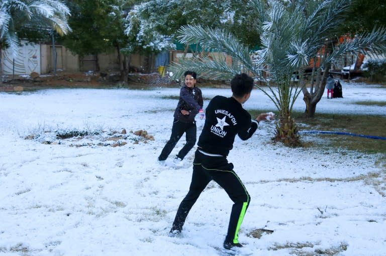
This is kind of crazy.... How much for Baghdad? 2nd snow in a century falls in Baghdad!

 
All jokes aside, the players are there for a potential ZR threat inside D10. If we know anything by now, it’s that no model is even close to a final solution at D10. Should be an interesting 12z suite
F59074B8-3C52-4FF5-A4A4-5307B99F6BC7.jpeg
 
This is kind of crazy.... How much for Baghdad? 2nd snow in a century falls in Baghdad!


HA....I was there the last time. That is crazy. Now when I deployed to Afghanistan different story when we did ops in the high peak mountain regions. It would dump on you at the drop of a dime.
 
Back
Top