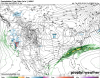
This is for feb 16th ending time stamp. The Macon Crusher for you Central Georgia posters suffering from February allergy season.


We’ve got some wiggle room up here..if you like iceThis is for feb 16th ending time stamp. The Macon Crusher for you Central Georgia posters suffering from February allergy season.
View attachment 33254
We’ve got some wiggle room up here..if you like ice
Larry,The 12Z GEFS is about to also come in colder it appears. I love the mostly silence because nobody believes this is for real. But is this going to be different?
In all my years of following models, this (12Z GFS) ranks near the top for 12 hour cold changes in the SE.
Wow, terrible for everyone East of the Mighty Mississippi, maybe the worst I've seen. Also looks terrible for the Sierra Navadas, who depend on snow melt for water. That's not a good thing come summer.Seasonal snowfall departures from average (thus far). Congrats northern Rockies & upper midwest.
View attachment 33251
Can it be right? LmaoThis is for feb 16th ending time stamp. The Macon Crusher for you Central Georgia posters suffering from February allergy season.
View attachment 33254
Can it be right? Lmao
And now similar to 12Z GFS at Happy Hour!I’ll be honest the trends have definitely been looking up as of recent ... Gfs completely flipped on the massive trough out west .. now has a major ridge in the same spot .. will help our chances down the line

Keep that movie reel spinning, Larry!
Actually a better look imo..for a snow setup with coastal low. And under 240hrs. Just need moisture thrown back west. Less of an ice setup. I see 1 or 2 potentials there for snow vs rain.Crazy gfs already lost the ice for the 16th lol
Sent from my iPhone using Tapatalk


Maples have buds all over themSaw multiple Bradford pear trees in full bloom with the rain around Greensboro today. 5+ weeks ahead of schedule. Forsythia, tullips
I'm not bragging or anything (in fact, complaining which I usually don't do) but my blueberry bushes - all 24 of them, were budding on Christmas day (and are full of flowers now) ...Maples have buds all over them

you know this is a little whamby i guess but it appears the most accurate long range forecast is one that goes completely opposite of JB & GEFS lol. (sarc but a little truth in there?? haha) Im actuallyAnother comparison of 0Z to the brand new much colder 18Z GEFS:
0Z:
View attachment 33283
18Z: much colder!
View attachment 33284
JB is always wrong no matter which way he goes. I am skeptical of some great pattern showing up. But maybe serviceable based on teles alone. NAO stays positve like always, but the AO has a sharp fall to maybe near neutral. PNA looks to go positive in that timeframe and the MJO appears to be phases 6 and 7 which aren't horrible for cold in February and March.you know this is a little whamby i guess but it appears the most accurate long range forecast is one that goes completely opposite of JB & GEFS lol. (sarc but a little truth in there?? haha) Im actuallyreallylittle intrigued by this period now.

To borrow a question I used to see "over there" ... How much for ... fill in the blank ?
Is the Euro also showing this cold?
Sent from my iPhone using Tapatalk
Is the Euro also showing this cold?
Sent from my iPhone using Tapatalk
You're my screen name mirror image...Currently snowing and 32 degrees at my location.