Snowflowxxl
Member
Guess we might see some flurries Friday morning. I would have never known had I not just checked the 3K NAM for severe tomorrow lol. Sadly this might be our best chance at seeing flakes here all winter.
Kinda rate dependent, if your get heavier rates you could drag cooler air to cool down the BL, I’d say areas around the upstate could see some wet snow mixed in the rain for now, altho this ain’t isothermal soundings, this is more BL issues which is honestly what I would rather have in my opinion vs having a sounding that’s isothermal and could easily go wrongWhat’s your thoughts on the upstate getting snow this weekend


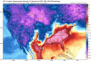
 Sounding from north GA
Almost the same exact setup as last weeks surpriseKinda rate dependent, if your get heavier rates you could drag cooler air to cool down the BL, I’d say areas around the upstate could see some wet snow mixed in the rain for now, altho this ain’t isothermal soundings, this is more BL issues which is honestly what I would rather have in my opinion vs having a sounding that’s isothermal and could easily go wrong
Gonna have to disagree here. I want it to snow but this looks much dryer and rate of precip should be less. Last week had heavy rates and bright banding. This does not look the same to me.Almost the same exact setup as last weeks surprise
Sent from my SM-G955U using Tapatalk
You do understand that "bright banding" is not necessarily heavy precip. It comes from melting hydrometers in the cloud layer which cause clumping of snowflakes. This can be seen with light to moderate precip rates.Gonna have to disagree here. I want it to snow but this looks much dryer and rate of precip should be less. Last week had heavy rates and bright banding. This does not look the same to me.
Yes. I’m just thinking there is no comparison with last weekend from what I’ve seen. Last week took advantage of the heavier widespread rates. Not gonna have that this time around outside of the mountain counties. Foothills won’t be included in this setup IMO.You do understand that "bright banding" is not necessarily heavy precip. It comes from melting hydrometers in the cloud layer which cause clumping of snowflakes. This can be seen with light to moderate precip rates.


This time the BL is colder. You won't need rates to cool it down. If we get any precip at all, it will be snow for the foothills. The only thing that I am concerned about is the lack of QPF.Yes. I’m just thinking there is no comparison with last weekend from what I’ve seen. Last week took advantage of the heavier widespread rates. Not gonna have that this time around outside of the mountain counties. Foothills won’t be included in this setup IMO.
9 times out of 10 if N GA gets it, North of 85 in the upstate gets it as wellThe angle and development of moisture also disfavors the NC piedmont areas esp where Frosty is in Mount Airy. I guess I’ll root for north Georgia and southwestern NC as this area is slightly better positioned in this setup IMO.
And some most people want another El Niño next winter lolFor me this is the most depressing winter I have ever experienced. I miss VT. I am sitting on a trace for the season and there is no hope as time runs out. It is a long wait until next year.
Post on Larry, at least it's a pretty blue instead of RED like we've seen since spring started in December............................... And most want admit it but deep down on the inside of our winter weenie it gives us a glimmer of hopeI know it is the horribly inaccurate CFS and it may reek of desperation to post it, but here it is anyway:View attachment 33147
 until reality sets in ?
I know it is the horribly inaccurate CFS and it may reek of desperation to post it, but here it is anyway:View attachment 33147
The Icon is really ramping things up even for upstate.
Sent from my SM-G955U using Tapatalk
9 times out of 10 if N GA gets it, North of 85 in the upstate gets it as well
Sent from my SM-G955U using Tapatalk
You mean snow is becoming rare these days... i fixed it for youI’m definitely a little excited to get some snow on the ground even if it isn’t a big one. I’ve been following this for days and it is actually trending better as we get closer which is rare these days.

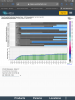
6Z GEFS will also come in colder than prior runs midmonth it appears from earlier maps based on much less SER. Buyer beware!
Edit: Actually, the last 3 runs have been coming in colder than each respective prior run.
[/
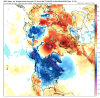
Is this the colder you are talking about? I am struggling to find much cold anywhere.
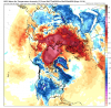
Cpc sure not buying in on that timeframe ... severe weather may have to Be watched closely during that time period be honest ...Dont sleep on the 14th-21st..classic set up for +500mb heights but - surface temp anomalies
Gefs and geps are both slightly below normalCpc sure not buying in on that timeframe ... severe weather may have to Be watched closely during that time period be honest ...