pcbjr
Member
hot damn ...

Not bad I’ll roll the dice with this. Can’t roll the dice when it’s hot coast to coast. This you can. Also good to see New England below maybe we can score with CAD.hot damn ...


To be very specific ... did I say I like it? Did I suggest that I like it? No and No.The fact that some people like this kind of weather map is baffling to me
To be very specific ... did I say I like it? Did I suggest that I like it? No and No.
Agree ... but IMHO (very humble) that is what late March, April and the 1st half of May are for (at least the fishing part) ... however, if one can't find time with family regardless of the time of year or the weather, then there's a whole 'nother discussion to be had ...Idk, but I love it, 70 degree days are really nice days where you could spend time outside with family or do activities like fishing
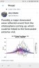
Yeah this could get a little interesting. Even the sounding for Monroe is very close. It’s gonna be interesting to see what the NAM has to say as it starts to come into range.... the NAM was the only model that had any period of snow in Monroe last Friday according to soundings and it was right.fwiw, gfs flizzard, I wonder if it’s catching on to the idea that there’s gonna be more onset precip like this last one, weird how there ain’t no accumulation especially around the western piedmont/foothills, the column is saturated View attachment 33022View attachment 33023View attachment 33024


Heavy enough rates at onset would probably do that.Gefs looks like a inch of snow into upstate sc. could it happen?
Sent from my iPhone using Tapatalk
Maybe I'm wrong, I just feel like a change to La Nina would shake up the global pattern at the expense maybe of next winter being horrible again . I don't knowt
give me La Niña every year


If this sucker would come in at night I feel like that would be super helpful. Where I stand it doesn’t look too hopeful but it does bear watching!fwiw, gfs flizzard, I wonder if it’s catching on to the idea that there’s gonna be more onset precip like this last one, weird how there ain’t no accumulation especially around the western piedmont/foothills, the column is saturated View attachment 33022View attachment 33023View attachment 33024
warmCan anyone understand what Dr. Butler is saying possible?
Are you sure?warm
Basically instead of the whole SSW, it looks more like a SSC, so a sudden stratospheric cooling, which would mean the AO would spike positive and high.Are you sure?

NoAre you sure?


Not much talk about this system on the wintry side, but this model and others are really increasing the chance for snow showers in the deep south. Worth watching and I'll take anything at this point.
View attachment 33035

Some of the GEFS members have been hinting at freezing rain by mid month and the subtropical jet looks to remain active as well. If that colder air pushes south and east and meets with that subtropical jet - we could have a catastrophic ice event.
Sent from my SM-A102U using Tapatalk

This needs to be watched the GFS over the last few runs keeps ramping up precip and bringing the rain/snow line farther south. And with rates that heavy it’s no wonder it keeps going farther south. Those are some heavy rates. I will also mention this is the warmest time of day so if it would speed up then temps would be lower at the start and if it slowed down temps would be falling. I still think it’s interesting how many areas have snow (per this map) even during the warmest time of day.
View attachment 33040

Yeah, I don't think there's going to be any solid chances of snowfall anytime soon, not with the SER holding it's position. Ice events can last way longer in the south than snow events.If we can’t have snow I’ll take a 2-3 inch freezing rain event.
Sent from my iPhone using Tapatalk
Yeah, I don't think there's going to be any solid chances of snowfall anytime soon, not with the SER holding it's position. Ice events can last way longer in the south than snow events.
Sent from my SM-A102U using Tapatalk
")


yea look at how the heaviest band of snow setup right over me!!! ?