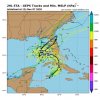
ETA looks good on satellite this morning but I'm not sold that it had a vigorous LLC yet, will wait for visible satellite. Regardless quite the mess shaping up. Once it crosses Cuba a south Florida or keys landfall looks probable as a TS maybe a low end hurricane depending how how the interaction with the upper low and the first legal landfall over Cuba impact the system. Even with that an expanding wind field looks likely as the storm starts to become more subtropical. The 1027-1030 high will be moving off shore increasing the gradient and onshore wind from NC southward so beach erosion will become an issue. After the potential landfall in SFL the system will likely be pulled west back into the gulf and moisture will start streaming northward into the SE as a front approaches associated with a trough passing through the lakes and the SE ridge gets squeezed a bit southeast. Pwats will increase and we will likely see near record high pwats for the time of year and have a good focus for rain/storms starting by mid week. A widespread 1-3 inches of rain for a good part of NC/SC/Ga looks likely with a core of 3-6 within that likely. I'm not sure a second landfall of ETA takes place the storm may eat so much dry air and shear as it interacts with the trough the LLC eventually spins down or dies off inching south. Regardless the southern and eastern parts of the Fl peninsula will have a few days of heavy rain and gusty wind.


