• Hello, please take a minute to check out our awesome content, contributed by the wonderful members of our community. We hope you'll add your own thoughts and opinions by making a free account!

Pattern ENSO Updates

The rapid warming in 3.4 continues. Per Tidbits, 3.4 has warmed over 0.7 C in just 6 days! It is now at +0.665 C. In the years that I’ve been following this graph, I don’t recall seeing a more rapid warming in 3.4:
https://www.tropicaltidbits.com/analysis/ocean/nino34.png

This is the kind of move often seen in the much more volatile 1+2 due to its small size but certainly not in 3.4. The TAO buoys support that there has been warming:
https://www.pmel.noaa.gov/tao/drupal/assorted_plots/images/sst_wind_5day_drupal.png

I’ll be surprised if Monday’s weekly release doesn’t show warming in 3.4 though sometimes those weeklies surprise me. One thing I’ll note that is keeping me from betting the ranch on the warming is that the Tidbits graph had been significantly cooler than the weeklies and TAO last week meaning some of this supposed rapid warming may really be just catching up to reality.
 
Last edited:
The latest OHC release has it now warmer than +1.50 C! That is actually warm enough to not just support weak El Nino, but it even allows for a good chance for the rapidly building moderate El Nino that the newest UKMET has. Here's why I say that:

Oct OHC > +1/year/Nino strength
+2.56/1997/super
+2.07/1982/super
+1.91/2015/super
+1.72/2002/moderate
+1.50/2018/????
+1.41/1991/strong
+1.12/1994/moderate
+1.04/2009/strong
We don't want Mod right, for our snow chances?
 
We don't want Mod right, for our snow chances?

Mod has been just about as good as any El Nino for snow chances, themselves, at least based on Atlanta history. I'm not talking NC, AL, or any other place. However, weak ones have been on average colder. Some of the great SE cold winters of the past were during a weak Nino such as 1885-6, 1904-5, 1939-40, 1969-70, 1976-7, and 1977-8. At ATL, 1904-5 was wintry and 1939-40 very wintry while the other 4 were fairly dry with below average wintry. From what I've seen, I'd favor pretty good wintry for ATL and much of the SE if we get a cold one.

You don't need weak to get cold and wintry. 2009-10 says hi! Likely because it was Modoki?
Thank you Larry, that makes everything much better now.
 
Thank you Larry, that makes everything much better now.

After some further analysis of the very warm OHC as shown above and when considering stronger forecasted 3.4 peaks on the UKMET and other models for this winter, I think it really is going to be difficult to end up with only a weak El Niño ONI peak this winter. And even a strong, which I had earlier given very low chance, now has to be given a higher chance than “very low”. Other opinions?

Oct OHC > +1/year/Nino strength
+2.56/1997/super
+2.07/1982/super
+1.91/2015/super
+1.72/2002/moderate
+1.50 and warming/2018/????
+1.41/1991/strong
+1.12/1994/moderate
+1.04/2009/strong
 
Last edited:
After some further analysis of the very warm OHC as shown above and when considering stronger forecasted 3.4 peaks on the UKMET and other models for this winter, I think it really is going to be difficult to end up with only a weak El Niño ONI peak this winter. And even a strong, which I had earlier given very low chance, now has to be given a higher chance than “very low”. Other opinions?

Oct OHC > +1/year/Nino strength
+2.56/1997/super
+2.07/1982/super
+1.91/2015/super
+1.72/2002/moderate
+1.50 and warming/2018/????
+1.41/1991/strong
+1.12/1994/moderate
+1.04/2009/strong

I think I'd rather take my chances with Mod instead of a strong El NIno.... although a strong can lend itself to big dog snows if everything else lines up just right, from what I've read about the only thing you can count on in a strong el nino is wetter than normal.

As far as chances of strong v. mod.... I haven't a clue b/c I'm still reading/learning about ENSO but looking at the trends that all of you have been posting it certainly would seem strong has to be considered a real possibility at this time.
 
This was posted somewhere back I'm sure or has been mentioned but I'll put it here as it seems to sum it up nicely...

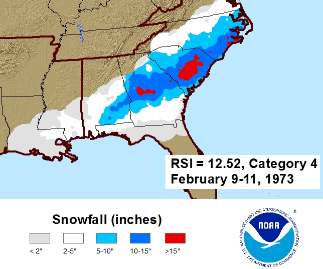
El Niño brings infrequent, but sometimes large snowstorms...


Feb1973snow.png

In contrast to rainfall, snowfall anomalies are not nearly as easy to predict during strong El Niño winters. During the El Niño winter of 1972-1973 the single largest snowfall ever seen in Florence and Columbia, SC occurred February 9-11, 1973. This was also the second-largest snowstorm on record in Wilmington, NC and Myrtle Beach, SC. Strong El Niños in 1991-1992 and 1997-1998 brought very little (if any) snowfall to the Carolinas. Nearly all stations reported below-normal or zero totals for those winters.

Even in a normal (non El Niño) winter snowfall statistics for the coastal Southeastern U.S. are -- strange. For example Wilmington's annual average snowfall is 1.6 inches. However snowfall statistics also show we average less than one measurable snow event per year. The standard deviation computed for Wilmington's historic snowfall events is much larger than the annual average!

Computing a simple average snowfall across the six previous strong El Niño winters shows above-normal totals all across the Carolinas. However this statistic is dominated by a small number of very large snowstorms, particularly during the winters of 1972-1973 and 1982-1983, which overwhelms the totals. El Niño does enhance the frequency of wintertime low pressure systems with heavy precipitation, a few of which may encounter cold enough air to produce snow across the Carolinas.
 

Attachments

  • Capture.PNG
    Capture.PNG
    20 KB · Views: 14
This was posted somewhere back I'm sure or has been mentioned but I'll put it here as it seems to sum it up nicely...

El Niño brings infrequent, but sometimes large snowstorms...


Feb1973snow.png

In contrast to rainfall, snowfall anomalies are not nearly as easy to predict during strong El Niño winters. During the El Niño winter of 1972-1973 the single largest snowfall ever seen in Florence and Columbia, SC occurred February 9-11, 1973. This was also the second-largest snowstorm on record in Wilmington, NC and Myrtle Beach, SC. Strong El Niños in 1991-1992 and 1997-1998 brought very little (if any) snowfall to the Carolinas. Nearly all stations reported below-normal or zero totals for those winters.

Even in a normal (non El Niño) winter snowfall statistics for the coastal Southeastern U.S. are -- strange. For example Wilmington's annual average snowfall is 1.6 inches. However snowfall statistics also show we average less than one measurable snow event per year. The standard deviation computed for Wilmington's historic snowfall events is much larger than the annual average!

Computing a simple average snowfall across the six previous strong El Niño winters shows above-normal totals all across the Carolinas. However this statistic is dominated by a small number of very large snowstorms, particularly during the winters of 1972-1973 and 1982-1983, which overwhelms the totals. El Niño does enhance the frequency of wintertime low pressure systems with heavy precipitation, a few of which may encounter cold enough air to produce snow across the Carolinas.
So in a strong El Niño we need all the pieces to get the snow and usually it’s one big one otherwise we bust?
 
That's kind of my interpretation of the relatively small sample size as well but I don't think it's all or nothing. There certainly can be mediocre winter events it just looks to me like there's no clear tendency one way or the other.
So in a strong El Niño we need all the pieces to get the snow and usually it’s one big one otherwise we bust?

Sent from my SM-G920V using Tapatalk
 
That's kind of my interpretation of the relatively small sample size as well but I don't think it's all or nothing. There certainly can be mediocre winter events it just looks to me like there's no clear tendency one way or the other.

Sent from my SM-G920V using Tapatalk

Here's the same analysis with more than double the amount of samples using pre-1950 ENSO data via my ENS ONI index.
Each red/blue color increment represents a difference of 0.5, 1.0, & > 2 sigma from the available NINO samples.

El Nino winters generally tend to slightly favor the piedmont and mountains if anything, there's some noise in the coastal plain and coastal areas like Wilmington. Charlotte actually averages more snow in strong-super El Ninos than Raleigh does, again hinting at this underlying favorability to the piedmont & mountains. We're clearly headed into a weak-moderate El Nino this year so I could do a similar analysis with even more samples and see if any discernible signal emerges, likely will be a muddled one if anything in the west-central piedmont and mountains.

Screen Shot 2018-10-17 at 2.42.35 PM.png
 
Here's the same analysis with more than double the amount of samples using pre-1950 ENSO data via my ENS ONI index.
Each red/blue color increment represents a difference of 0.5, 1.0, & > 2 sigma from the available NINO samples.

El Nino winters generally tend to slightly favor the piedmont and mountains if anything, there's some noise in the coastal plain and coastal areas like Wilmington. Charlotte actually averages more snow in strong-super El Ninos than Raleigh does, again hinting at this underlying favorability to the piedmont & mountains. We're clearly headed into a weak-moderate El Nino this year so I could do a similar analysis with even more samples and see if any discernible signal emerges, likely will be a muddled one if anything in the west-central piedmont and mountains.

View attachment 7028
Don't you think some of those averages may be skewed by some less occurring but very significant winter storms? It just seems to me that the one constant with mod to strong el nino's is a wetter than average pattern and temps are a little bit more of a crap shoot. I'm wondering if, even in the more favored western areas, that saw big totals in El Nino years was just one or two big dog events because of more juice up atmosphere. Just thinking out loud here....

While the number of above average outweigh the below average in that chart, in those below average years there are a lot of goose eggs
They’re definitely skewed, the climatological seasonal snowfall distribution in the coastal plain and coastal areas is logarithmic, generally satisfying the Zipfian distribution where about 80% or so of the total snowfall for a given area occurs in about (or less than) the top 20% of winters, it partially explains why we don’t see much of signal outside the piedmont and mountains but as you go further NW towards areas like the Triad and Asheville, we usually see several events per year many of which are moderate or large. A majority of the big winters snowfall-wise around here even in the good ol days usually feature one maybe two “massive” snowstorms and a couple moderately sized events. 1935-36 is a very notable exception to this stereotypical behavior in big winters w/ a parade of several moderate-large winter storms annihilating NC east of the mountains & producing a statewide mean above 25” or about 3.5-4x the long term average.
 
Give me a super suppressed pattern and I’ll take my chances. I’d rather have a swing and a miss LP tracking across central/south Florida than a coastal scraper with borderline temps. Let’s get that STJ pumping in Mid December and ride it til the bitter end
 
They’re definitely skewed, the climatological seasonal snowfall distribution in the coastal plain and coastal areas is logarithmic, generally satisfying the Zipfian distribution where about 80% or so of the total snowfall for a given area occurs in about (or less than) the top 20% of winters, it partially explains why we don’t see much of signal outside the piedmont and mountains but as you go further NW towards areas like the Triad and Asheville, we usually see several events per year many of which are moderate or large. A majority of the big winters snowfall-wise around here even in the good ol days usually feature one maybe two “massive” snowstorms and a couple moderately sized events. 1935-36 is a very notable exception to this stereotypical behavior in big winters w/ a parade of several moderate-large winter storms annihilating NC east of the mountains & producing a statewide mean above 25” or about 3.5-4x the long term average.
I think I'm picking up what you're dropping down haha. Basically maybe some would say I'm being a Debbie Downer or don't know what I'm talking about, which the latter is quite possible. I'm playing Devil's Advocate or just being a realist but in my humble opinion an El Nino basically says I'm supplying the fuel but the rest of the players need to step up to close the deal.

Sent from my SM-G920V using Tapatalk

substitute "fuel" for "beer and shrimp" and you got it nailed ... :D
 
Back
Top