• Hello, please take a minute to check out our awesome content, contributed by the wonderful members of our community. We hope you'll add your own thoughts and opinions by making a free account!

Pattern ENSO Updates

Subsurface anomalies are clearly headed in the direction of neutral ENSO as a downwelling kelvin wave cross the EQ Pacific, it may take a while for the surface to respond. Regardless, just wait til you see the next oceanic Kelvin wave this WWB generates.
wkxzteq_anm.gif
u.anom.30.5S-5N.gif
 
It was -0.6 in last week's report. Today's report has it down slightly to -0.7.

Region 3.4 in today's report, which is the average for last calendar week, dropped from -0.7 to -0.9 interestingly enough.
 
The clock is ticking for when this downwelling Kelvin Wave will appear over the West Pacific in response to this intense and prolonged WWB over the central EQ Pacific. It usually takes about 2 months or so for an oceanic Kelvin Wave to traverse the entire length of the Pacific and reach the eastern boundary region (South America) so we wouldn't begin to feel the sensible impacts of this KW until we are closing in on April at the earliest, if not later. Even then, it will likely take some time for the atmosphere to respond thereafter. The Kelvin Wave that formed in the WP back in November and early December has already reached the East Pac, the subsurface heat content is near normal and this KW should take some of the bite out of this La Niña
 
View attachment 3805

View attachment 3804

"The majority of ENSO events in both nature and the coupled model are preceded by MM (Pacific meridional mode) events."
https://journals.ametsoc.org/doi/abs/10.1175/2008JCLI2473.1

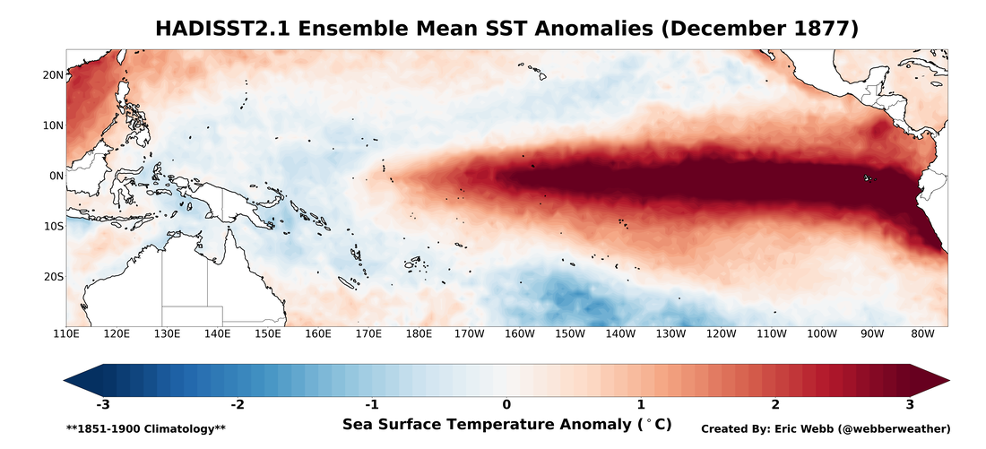
Evidence is certainly beginning to mount in favor of El Nino but we have a long ways to go.

To add onto this, this particular study generally found that about from observations and NWP models, approximately 2/3rds of all El Ninos were preceded by a positive Pacific Meridional Mode (PMM) event. This past January's PMM value set a new all-time record high and was almost the highest for any month in the historical record. I'm not saying that an El Nino is going to happen, but in combination w/ the MJO, we are literally doing everything right to set ourselves up for one next year. We'll have to see if we keep this up thru the spring predictability barrier.
January Pacific Meridional Mode (PMM) 1948-2018.jpg

Doesn't get more classic than this.
pac.gif
cdas-sflux_ssta_cpac_1.png
 
IMG_0954.JPG

This is just pure insanity, the MJO has spent about 10 days already in the Western Pacific with amplitude of at least 3.5-4 sigma, this will be the final nail in the coffin for our La Niña
 
This current WWB sticks out like a sore thumb.

u.anom.90.5S-5N.gif


Even that modest WWB in mid December was able to trigger a oceanic KW w/ 5C anomalies along the thermocline, it dampened however thanks in large part to the huge easterly trade wind surge that followed not to mention the seasonal base state wasn't as favorable as it is now. I can only imagine how large this next Kelvin Wave is going to be.
Screen Shot 2018-02-10 at 12.02.49 PM.png
 
Another pretty stout WWB near the dateline is looming on the horizon by day 4 according to the GFS which would only further augment the downwelling Kelvin Wave in the WP.
u.anom.30.5S-5N.gif
 
This February's SOI is going to be one of the most negative non-El Nino values we've ever observed in the last century and a half. We're running at -17 for the month, some positive values should begin to appear the last few days of the month but it's most likely gonna be too little too late
 
Meanwhile, the latest weekly 3.4 cooled slightly from -0.9 to -1.0, the coolest in 2 months.
 
Back
Top