Avalanche
Member
Let's go!!!CMC agrees as well .. that will be a chilly couple days at this rate .. our first cold rain CAD yummy .. cmc actually has some snow flakes on the VA/NC border lol
Let's go!!!CMC agrees as well .. that will be a chilly couple days at this rate .. our first cold rain CAD yummy .. cmc actually has some snow flakes on the VA/NC border lol
I don’t see a big ridge filling the middle of the country with a trough situated on both coasts. These two usually can’t coexist. That little block looks favorable. Cant wait to punt then unpunt a few more times over the next 30 days.The 12z Euro from today actually looks good for later in the future this month - still currently thinking a colder pattern settling in within 2 - 2 and a half weeks. If you take a look upstream over the EPO (and part of the PNA) region, there's a deep trough that I beleive will transpire east of the Rockies between the 17th and 22nd (give or take) The waves from Russia would force the North Pacific blocking into the PNA region while some sections of the sinking air may become separated and go poleward. The blocking across the Central US I think would be a transitional warmth as the flow continues to propagate and that area of air I think would get forced over Greenland causing a possible strong -NAO signature.
I actually seem to remember them calling for a full on torch to start just after Thanksgiving and continued for much of December. What they put out today really isn’t much different from what Webb was talking about earlier, except their timing is sooner. I tend to lean more toward Webb’s thinking on the timing.Weren’t they touting big cold for December anyhow ? So now that it’s in jeopardy no surprise they are finessing any possible way to show it will still get cold . Lol.
Yep all this looks like is shortened wavelengths and then a boot of the EC trough and back to a EC ridge while the western trough ejects eastward, that blocking on top is weakI don’t see a big ridge filling the middle of the country with a trough situated on both coasts. These two usually can’t coexist. That little block looks favorable. Cant wait to punt then unpunt a few more times over the next 30 days.
Yeah this is a good point. While the short wavelengths are nice for the time being they aren’t sustainable for very long in the dead of winter. In the shoulder season (perhaps late Feb and into March) it’s a somewhat different story.I don’t see a big ridge filling the middle of the country with a trough situated on both coasts. These two usually can’t coexist. That little block looks favorable. Cant wait to punt then unpunt a few more times over the next 30 days.
A ridge may not come into place, however if that strong frontal passage occurs, a strong high is likely to build in - causing higher heights behind the front. Since the higher heights would be associated with a transitioning high, the blocking will not be stationary. Those particular higher heights are within the main flow of transition over the Continental US.I don’t see a big ridge filling the middle of the country with a trough situated on both coasts. These two usually can’t coexist. That little block looks favorable. Cant wait to punt then unpunt a few more times over the next 30 days.


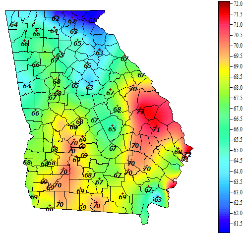
CAD really stuck through the operational I think that could be the reason for almost near normal readings for a lot of the SEGefs says what cool shot View attachment 96742


That’s a huge signal for this far. I wouldn’t be shocked if this pattern stays locked in for most of the winterMerry Christmas View attachment 96747View attachment 96748

Even though this is extended you have to expect we eventually make it to phase 8 and at what better time than early January we end up getting there

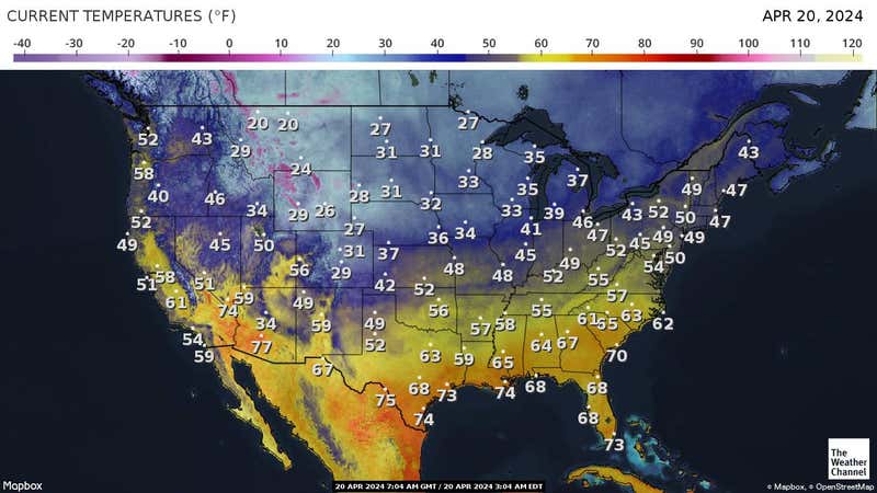
Might as well make the most of it. I got a 9:50 tee time in the morningMan tomorrow isn’t looking much different from today View attachment 96753
Even though this is extended you have to expect we eventually make it to phase 8 and at what better time than early January we end up getting there
We may never officially reach phase 8, even if we don’t that really doesn’t matter imo. Phase 7 is just as good if not even better in January (& best overall). Slow moving MJO events like this one have a tendency to produce a strong -NAO when we reach phase 7 & 8 in January. You can see a slight hint of that on the extended GEFS and the +SCAND showing up in the medium to long range is also one of the most classic circulation precursors to -NAO. I stand by what I’ve been posting the last few days, the flip to a potentially legit pattern is delayed probably until very late Dec or early January.


Once upon a time we would have been stoked for a potential late Dec/early Jan flip, but now there’s trepidation due to being burned so many times. I’m trying to find some chill and remember this could be just fine timing.We’ll probably have a decent idea on when this pattern flip may occur later this coming week as our West Pac MJO event continues to amplify, but I think many are jumping the gun. Looks like rough sledding overall to me (no pun intended) until at least the Christmas holiday or so in the SE US. Winter probably gets going much earlier to our NW over the Midwest and Rockies


Almost had to turn the heat on this morning, almost.