Gefs looked better at H5 but was wasnt great at all
-
Hello, please take a minute to check out our awesome content, contributed by the wonderful members of our community. We hope you'll add your own thoughts and opinions by making a free account!
You are using an out of date browser. It may not display this or other websites correctly.
You should upgrade or use an alternative browser.
You should upgrade or use an alternative browser.
Pattern December to Remember
- Thread starter SD
- Start date
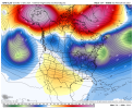
I like that much better. Like I said yesterday move the EPO block north and east and the NAO block more west and we would be set. Just a couple hundred miles is the difference between a rollercoaster of up and down temps and cutters, to a legit pattern capable of a winterstorm.This is a textbook perfect pattern at the end of the GFS.
View attachment 97751
Another 25 mega frost morning, wen torch?
Blue_Ridge_Escarpment
Member
Bottom fell out here last night with clear skies and calm wind and a big frost by 9PM. 19 degrees.
25 as well here with a mega frost.Another 25 mega frost morning, wen torch?
Webberweather53
Meteorologist
This is a textbook perfect pattern at the end of the GFS.
View attachment 97751
It's been so hard to get -EPO & -NAO simultaneously for any extended length of time. Glad to see it consistently on NWP
Webberweather53
Meteorologist
If there was one big caveat to this pattern is that our ridge in the N Pacific is flatter and south of Alaska (thus the intruding air mass isn't quite as cold)
bigstick10
Member
Looks like I, we, woke up to a nightmare forecast...
iGRXY
Member
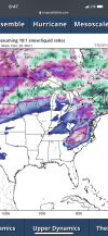
What's even a little more interesting is the GFS has always been really bad for CAD so if this is the look it has at this range, then oh man. Usually I am not buying anything these models say post day 5 and this is day 9 but the GFS has definitely been hinting at this for a while and the pattern is prime for a CAD event of some sort. Whether it be a cold rain or potentially this.This isn’t even far out anymore. Wtf View attachment 97743View attachment 97744View attachment 97745View attachment 97746View attachment 97747
Blue_Ridge_Escarpment
Member
Actually day 7 nowWhat's even a little more interesting is the GFS has always been really bad for CAD so if this is the look it has at this range, then oh man. Usually I am not buying anything these models say post day 5 and this is day 9 but the GFS has definitely been hinting at this for a while and the pattern is prime for a CAD event of some sort. Whether it be a cold rain or potentially this.
SnowNiner
Member
Well the GEFS finally got the reds and oranges off MBY at 384! So there's that! I do like the -NAO with a real/true 50/50 low signature (NO WAR, YAY!! hope that stays!). Hate the orientation and location of the pacific ridge, too west and south. Polar air still comfortably tucked in west out in Canada. Still not very optimistic with only the -NAO on our side but we'll see. Perhaps if the Alaskan Ridge could connect to the Greenland Ridge, then that's a whole new ball game, but not seeing that other than the CFS.....lol.
I look at December as being the time to establish the pattern for the upcoming winter. The theme so far continues to be cold trapped out west as far as the eye can see, and potentially -NAO. Maybe our -NAO CAD will be colder this year, I don't know. My guess at this point is that's the theme of winter, mostly warm, with bouts of CAD and threats of CAD events. Hopefully it'll get cold enough to push us past the misery of the constant cold rain events of last year.


I look at December as being the time to establish the pattern for the upcoming winter. The theme so far continues to be cold trapped out west as far as the eye can see, and potentially -NAO. Maybe our -NAO CAD will be colder this year, I don't know. My guess at this point is that's the theme of winter, mostly warm, with bouts of CAD and threats of CAD events. Hopefully it'll get cold enough to push us past the misery of the constant cold rain events of last year.


Eps mean was lower with heights in the east from about 180 onward and cooler at 850 & sfc through that time frame for the most part.
Here is the spread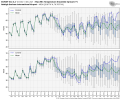
Look at how long the boxes and whiskers are getting. Not much agreement on the middle percentiles much less the overall spread post 12/23.
Here is the plume view. Looks like there's 2 camps with not a lot in the middle
Here is the spread

Look at how long the boxes and whiskers are getting. Not much agreement on the middle percentiles much less the overall spread post 12/23.
Here is the plume view. Looks like there's 2 camps with not a lot in the middle

Last edited:
Another thing that I can’t help but notice is the very mild temperatures this weekend. It seems can remember a number of times over the years that significant CAD storms were preceded by a couple days of very mild temperatures… February 1994 and December 2002 really jump to mind.What's even a little more interesting is the GFS has always been really bad for CAD so if this is the look it has at this range, then oh man. Usually I am not buying anything these models say post day 5 and this is day 9 but the GFS has definitely been hinting at this for a while and the pattern is prime for a CAD event of some sort. Whether it be a cold rain or potentially this.
Did I miss something? Atlanta under a high risk for severe? Tornado threat bearing down on you?Looks like I, we, woke up to a nightmare forecast...
I don't know how it correlates but my biggest ice and snow here in the foothills almost always comes on the heels of a warm up. Definitely has my attention. This is why u don't hug anything past day 5.Another thing that I can’t help but notice is the very mild temperatures this weekend. It seems can remember a number of times over the years that significant CAD storms were preceded by a couple days of very mild temperatures… February 1994 and December 2002 really jump to mind.

