Webber, does a typhoon recurve help lock in the blocking?
The background state w/ negative Atmospheric Angular Momentum dominating the mid-latitudes, a strong subtropical jet core, hastened by a equatorward propagating and strong wave train (which derived its energy in part from the once very persistent and strong planetary scale ridge over the Aleutians) over the western hemisphere, in addition to proper placement of these waves in the troposphere (superimposed onto the mean mid-upper level planetary waves) is disrupting the polar vortex and all of this I just mentioned is already helping to establish and "lock in" the blocking we're currently seeing (& about to see) over the North Atlantic, North Pacific, and Arctic.
In summary, we already have a damn good pattern and background forcing for creating sustainable, long-term high latitude blocking. A typhoon recurvature working in conjunction with a slow-moving, convectively coupled kelvin wave through diabatic heating (released via large-scale condensation processes in the typhoons) and geostrophic adjustment of the subtropics and mid latitudes in response to this tropical heating source would force a huge rossby wave packet emanating downstream from the typhoons which would further amplify an already amplified pattern over our neck of the woods. In essence, this means an already cold pattern could get even colder...
A good analogy to what I just described is think of the typhoons and the response in the mid latitudes like throwing a gigantic rock into a lake. When it's relatively still, as is often the case (except now), it creates pretty large ripples that disperse outward in all directions and are easily traceable...
(akin to ageostrophic geopotential flux & Rossby wave dispersion that propagates the Rossby Wave packet downstream from the heating source generated by the typhoons in West Pacific to other parts of the world like North America). However, what if say, there are other boats speeding thru the lake that have already created a bunch of big waves and the water in the lake is more turbulent to begin with? This kind of like how the mid-latitude -AAM, tall/persistent Aleutian ridge, and planetary wave alignment in an attempt to destroy the polar vortex, have aligned to create this amplified pattern here in the Western Hemisphere. Then, you decide throw the gigantic rock into the lake, what do you think is going to happen to the waves that have already been stirred up by the boats? The waves generated by the rock and the boats will interfere with one another and the amplitude of the waves and crests of the highest waves will increase, although some waves may completely disappear due to
destructive interference w/ one another.
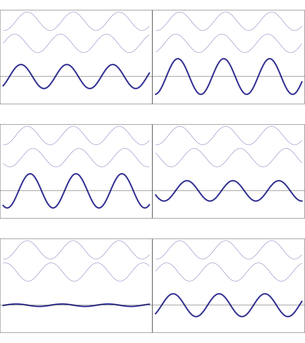
This animation from PSU illustrates this aforementioned wave interference pattern pretty nicely. You can relate to this what we observe in real time w/ the top, stationary wave representing the quasi-stationary, low frequency, and large planetary waves and the middle, moving wave to represent the more transient, faster moving mid latitude disturbances, and the third wave pattern on the bottom shows what is actually observed. Notice when the stationary and relatively fast moving waves align w/ one another, the amplitude of the observed wave increases and vis versa. This is analogous to what I'm trying to say here, in that the Rossby Wave train that's generated by the Western Pacific typhoons could lead to even larger troughs and ridges downstream here because if the waves embedded within the Rossby Wave packet align w/ the quasi-stationary planetary waves then they'll
constructively interfere w/ one another, causing the observed wave pattern to become more amplified (& "blocky" in this case).
This image of 200 hPa stream function shows what happens when a remote tropical heating source in the central Pacific forces downstream parade of Rossby Waves... Note the waves veer poleward and then are deflected to the east, this is due to the stronger influence of the coriolis force in the mid-high latitudes. Also notice that the amplitude of the waves (which represent troughs/ridges) decreases w/ distance away from the tropical source, processes such as friction, damping due to diabatic or solar heating, and dispersion, among others explain why this is the case.
(As an aside streamfunction is essentially like geopotential height you see on an every day 500 hPa height map, except the flow is purely non divergent. So in essence, it's showing you height contours, but unlike w/ geopotential height on an isobaric (equivalent pressure surface) where the winds can cross height contours, here the winds are perfectly aligned with the height contours. Sometimes you'll often see streamfunction and another more well recognized variable (velocity potential) shown on sigma surfaces (like .2101 sigma for ex), it's a height surface except its corrected for surface elevation. So unlike pressure which can dip under tall mountain ranges like the Rockies or Himalayas (like the 850 hPa surface for ex), sigma surfaces don't do that)


