packfan98
Moderator
Thanks. That’s what I was seeing too, but I hadn’t dove into the data or been following them closely like you have been. Encouraging trends.Thank you!
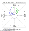
1. Sig. colder 12/29-1/5 vs yesterday but we already knew that. Two days ago, they had solidly AN in the SE. Todays has NN to a little BN for that week! Tomorrow’s may be even colder.
2. The rest of the weeks are still mainly AN but not really torchy. However, with them recently struggling with 12/29-1/5, I suspect that colder changes will occur as we get closer to each week. That’s especially the case if the Jan 2022 analog and other analogs with a +PNA Jan following a -PNA Dec during -ENSO end up being a good guide and a switch to a +PNA ends up occuring. That’s also considering the likelihood of a -WPO in Jan due to the strong Dec -WPO.
.gif")