That mega frost Saturday morning is going to be 
-
Hello, please take a minute to check out our awesome content, contributed by the wonderful members of our community. We hope you'll add your own thoughts and opinions by making a free account!
You are using an out of date browser. It may not display this or other websites correctly.
You should upgrade or use an alternative browser.
You should upgrade or use an alternative browser.
Pattern December Doldrums 2025 🎄 ❄️
- Thread starter SD
- Start date
NBAcentel
Member
iwantsouthernsnow123
Member
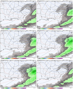
Either AIFS is just completely wrong or it's onto something. Given how EPS and Euro Operational has trended, I am starting to have interest in AIFS with this one.
Blue_Ridge_Escarpment
Member
18Z Euro OP following suit
NBAcentel
Member
Brother loves some mega frost lmaooooooooooooooooThat mega frost Saturday morning is going to be
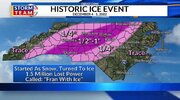
Remember it well. Woke up asking my wife “who the heck is shooting at this hour?” Then realized it was all the pine trees in our neighborhood snapping in two like matchsticksThe golden standard for winter disasters around here. I can still hear the trees snapping View attachment 178015
Last edited:
Best winter events we get these daysBrother loves some mega frost lmaoooooooooooooooo
The sounds of trees snapping that night was surreal. 17 hours straight of light freezing rain and temperatures hovering around 28.The golden standard for winter disasters around here. I can still hear the trees snapping View attachment 178015
I hope we can build the snowpack in Florida before ChristmasView attachment 178017
The coastal Louisiana mixed bag is setting the table for the Christmas mega storm in NC. Need to build the ice/snow north and south of you before you cash in!
olhausen
Member
Sleet and zr despite radar showing snow. Baby raccoons came out to play in it!


Sent from my iPhone using Tapatalk


Sent from my iPhone using Tapatalk
- Joined
- Jan 23, 2021
- Messages
- 4,602
- Reaction score
- 15,197
- Location
- Lebanon Township, Durham County NC
Scarier than Hugo and I’ll say that until the day I dieThe golden standard for winter disasters around here. I can still hear the trees snapping View attachment 178015
FoothillsWX
Member
1041 over WV? Might snow in Miami.View attachment 178017
The coastal Louisiana mixed bag is setting the table for the Christmas mega storm in NC. Need to build the ice/snow north and south of you before you cash in!
This ice storm did more damage in my yard and neighborhood than Fran did. The ice accrual did a number on the pine trees in my yard and all up and down the street where I lived. The smell of pine permeated the air where I live for days after the storm.The golden standard for winter disasters around here. I can still hear the trees snapping View attachment 178015
Ditto. 1.5 frzng rain with a temp of 23. Sat in dark for 9 days. Whole county lost power. Mall was closed for a week.Scarier than Hugo and I’ll say that until the day I die
Blue_Ridge_Escarpment
Member
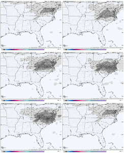
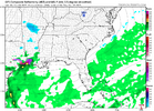
0Z NAM looks like it may be trying to go the way of Euro AI
iwantsouthernsnow123
Member
Interesting, but if there's one thing I've learned. NEVER TRUST NAM. Euro AI, and euro appearing to trend that way does make it more interesting though. But I'd like to see more support from other ensembles and operational models.0Z NAM looks like it may be trying to go the way of Euro AI
Blue_Ridge_Escarpment
Member
Never trust the NAM alone, but if you get the EE rule, it’s on lock.Interesting, but if there's one thing I've learned. NEVER TRUST NAM
iwantsouthernsnow123
Member
Yeah that's true as well, although it's certainly not a lock yet. Things are looking interesting but I can also think of similar setups that end up doing nothing at all. I'm unsure what analogs we have of a setup like this, havent looked into analogs yet.Never trust the NAM alone, but if you get the EE rule, it’s on lock.
While I never look at the NAM for specifics this far out, I still think it’s a useful tool to look at where it’s H5 set up is trending towards and right now we have the EURO AI, AI ensembles, EURO op and ensembles as well the NAM appearing to go in the same directionInteresting, but if there's one thing I've learned. NEVER TRUST NAM. Euro AI, and euro appearing to trend that way does make it more interesting though. But I'd like to see more support from other ensembles and operational models.
Cad Wedge NC
Member
Yeah, looks like we have a credible threat to track. Trends are certainly heading in the right direction.While I never look at the NAM for specifics this far out, I still think it’s a useful tool to look at where it’s H5 set up is trending towards and right now we have the EURO AI, AI ensembles, EURO op and ensembles as well the NAM appearing to go in the same direction
iwantsouthernsnow123
Member
Yeah I agree with this completely, I've been watching this one for a couple days. We'll know a lot more once the vort enters the US. It's still out in the pacific right now. We've got a few days before OBS data.While I never look at the NAM for specifics this far out, I still think it’s a useful tool to look at where it’s H5 set up is trending towards and right now we have the EURO AI, AI ensembles, EURO op and ensembles as well the NAM appearing to go in the same direction
Have you guys seen the temps over the Midwest right now with the snowpack? Single digits all over.
JP152
Member
Yep. 1.6 at the house right now. About 6 inches on the ground. Only got up to 16 today.Have you guys seen the temps over the Midwest right now with the snowpack? Single digits all over.
That's awesome. Y'all keep building that snow pack!Yep. 1.6 at the house right now. About 6 inches on the ground. Only got up to 16 today.
It’s been some years since we’ve seen good snowpack in December even in Canada. Honestly this is a way that we can see “homegrown” cold air be cold enough the further into December we goHave you guys seen the temps over the Midwest right now with the snowpack? Single digits all over.
JP152
Member
Haha, yeah no problem. Never even seems to get to freezing here. WARM tomorrow, looking for 30-31.That's awesome. Y'all keep building that snow pack!
This one is going to be tough to pull off for us, even for your corner of NE Ga. Boundary level temps look a bit too warm, and our CAA is from the NW. The only shot is a considerably stronger surface low than looks possible given the current guidance IMO.Yeah I agree with this completely, I've been watching this one for a couple days. We'll know a lot more once the vort enters the US. It's still out in the pacific right now. We've got a few days before OBS data.
BrickTamland
Member
People, we really need to get ourselves aligned here. It's game time. It's no time for JV ball. We gotta step it up. Snow is coming. It's going to be a good winter.

Blue_Ridge_Escarpment
Member
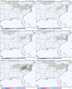
Beat me to it. Big nodICON trended towards EURO camp majorly at 0z
Sent from my iPhone using Tapatalk
CNCsnwfan1210
Member
ICON trended towards EURO camp majorly at 0z
Sent from my iPhone using Tapatalk

Sent from my iPhone using Tapatalk
Just to see NC and VA fantasy runs? Nahhwho's staying up for the 0z gfs and euro runs?
CNCsnwfan1210
Member

A few more tweaks like that will make this interesting
Sent from my iPhone using Tapatalk
accu35
Member
PATTERN FLIPPING TO A MORE ACTIVE/SNOWY SETUP?
Alright, I hear you… WE. WANT. SNOW. (Well… some of you do. The snow-weenies are definitely the loudest.)
 There are signs the pattern may finally start bending in your favor. In 8-10 days The EURO and GFS are both hinting at a shift toward a more blocky look over Greenland and the West Coast (outlined below). That’s a notable change from our recent split-flow, zonal, cold-but-quiet pattern. A blockier setup creates a wavier jet, which can help energy consolidate (“bundle”) as it drops into the eastern U.S. — a key ingredient for storm development.
Another big signal: the SOI has gone into a major free fall, which often points to a more energized southern jet stream. The MJO is also shifting convection into the central Pacific — a classic bellwether for a more active storm track in the weeks ahead.
This doesn’t guarantee a snowstorm in the next 10–15 days, but it does suggest the early January pattern could turn much more interesting for winter lovers.
See you at 4am - 10am on PIX11
Alright, I hear you… WE. WANT. SNOW. (Well… some of you do. The snow-weenies are definitely the loudest.)
Another big signal: the SOI has gone into a major free fall, which often points to a more energized southern jet stream. The MJO is also shifting convection into the central Pacific — a classic bellwether for a more active storm track in the weeks ahead.
This doesn’t guarantee a snowstorm in the next 10–15 days, but it does suggest the early January pattern could turn much more interesting for winter lovers.
See you at 4am - 10am on PIX11

