AI GEFS at Day 15I wonder if the new AI GEFS looks any better, because that’s not even close to agreeing with the AIFS.
Sent from my iPhone using Tapatalk


AI GEFS at Day 15I wonder if the new AI GEFS looks any better, because that’s not even close to agreeing with the AIFS.
Sent from my iPhone using Tapatalk


You right friendHard to really complain man. This was supposed to be a torch timeframe. We working with house money.


This 100%!!!! It’s been a while since we’ve seen a good healthy December snowpack in place to the north.We really should be rooting for that storm next week to lay down a thick glacier over the Midwest/northeast. That should help improve our odds during the second half of the December 8-1-2 run, plus we’re at solar min so it should stick around a while.

This 100%!!!! It’s been a while since we’ve seen a good healthy December snowpack in place to the north.

Happy Thanksgiving Mark. Maybe we can score us one around Christmas time.It has been a long time since this has been then case. Rooting for it!
Sent from my iPhone using Tapatalk

I think so. I know it’s extremely cliche to say, but everything past like 7 days isn’t reliable at all with how flip floppy everything is. I just don’t think guidance has a clue.View attachment 177345
So we will be phase 8 around this time here…
Should we expect this trough on the WC to shift east over time?
View attachment 177345
So we will be phase 8 around this time here…
Should we expect this trough on the WC to shift east over time?


Very true and of course we’ve already seen modeled WC trough after the other disappear the last several monthsEven if the almost always very unreliable day 15 snapshot doesn’t shift and there’s a trough on the WC on day 15, this is only a day 15 snapshot. What would the days just beyond show? Plus most of the days before day 15 on this run have higher hts WC. We all know that for short periods H5 could vary significantly from the longer term mean.
If the more favorable phase 8 progs today vs yesterday are not enough good news for those who prefer it cold in the E US, I’ve got more:
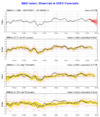
Yesterday’s (11/26) GEFS NAO through 12/10: headed to moderate +NAO
View attachment 177346
Today’s (11/27) GEFS NAO through 12/11: no +NAO as it stops rising at dead neutral (0):
View attachment 177347

Also just a few days ago it had no -NAO at any time on it.If the more favorable phase 8 progs today vs yesterday are not enough good news for those who prefer it cold in the E US, I’ve got more:
Yesterday’s (11/26) GEFS NAO through 12/10: headed to moderate +NAO
View attachment 177346
Today’s (11/27) GEFS NAO through 12/11: no +NAO as it stops rising at dead neutral (0):
View attachment 177347

This morning’s CFS AO forecast
Sent from my iPhone using Tapatalk


EURO will eventually continue the move South with its (colder) runs and you can already see some indications of this as posted in GaWX post on the previous page. Euro has a tough time picking up on the cold air until later in the game, especially early in the season. With the volatility being the norm on the deterministic models lately, stick to the ensembles for a more
Sounds like good ole JB. As he said good time Thanksgiving to Christmas best times for nowEURO will eventually continue the move South with its (colder) runs and you can already see some indications of this as posted in GaWX post on the previous page. Euro has a tough time picking up on the cold air until later in the game, especially early in the season. With the volatility being the norm on the deterministic models lately, stick to the ensembles for a more likely scenario

I noticed a south trend from the gfs and cmc today with next week storm
I expect the SE ridge not to be there at all when December the 12th arrives.View attachment 177345
So we will be phase 8 around this time here…
Should we expect this trough on the WC to shift east over time?
It's pretty common for the models to underestimate the magnitude of cold air jamming as we move in. So it's something to watch for sure.


.png")