• Hello, please take a minute to check out our awesome content, contributed by the wonderful members of our community. We hope you'll add your own thoughts and opinions by making a free account!

Wintry December 28-29th Possible Winter Storm

I’m leaning towards more sleet. It just seems like it may be just cold enough for some areas to get by with sleet but barely. This is gonna be a nail biter. I swear I’ve seen this dance before but can’t remember the dang year!


Sent from my iPhone using Tapatalk
 
Initial precipitation breaks out at hour 102 in Central AR. I would imagine if temps were lower than what’s currently being shown this could be a bigger threat for the Mid-South and points east.
 
Guys, 06z GFS is a major Winter Storm (again) for a lot of us. A line from Orangeburg, Maybe Augusta North through the central Midlands and through parts of GA will get raked if it's true.

Falling in line with the Euro & CMC.
 
Here is the 06z freezing rain map.
 

Attachments

  • zr_acc.us_se.png
    zr_acc.us_se.png
    281.8 KB · Views: 119
So as of now; parts of the SE have:

JMA
GGEM
GFS
Euro
FV3
GEFS
EPS
GEPS
UKMET

On their side for a Wintry threat!

I think that's all of them. Lets see just how cold and wet these runs become! Again, NAM is best for temp profile!
 
As for my neck of the woods, I think I won't have much to worry about when it comes to ZR because a lot of the models have constantly had me in sleet for the most part.
 
Euro 12z
and 00z
Not too much difference here:-(
ecmwf_acc_snow_conus_174.png

ecmwf_acc_snow_conus_162.png
 
So as of now; parts of the SE have:

JMA
GGEM
GFS
Euro
FV3
GEFS
EPS
GEPS
UKMET

On their side for a Wintry threat!

I think that's all of them. Lets see just how cold and wet these runs become! Again, NAM is best for temp profile!
You forgot :DWD icon
 
The 00z of Euro looks more reasonable with a NW flow and overrunning event . Usually dry and cold east of mountains from VA to NC / SC boarder until you get to piedmont areas were it can redevelop
 
The 00z of Euro looks more reasonable with a NW flow and overrunning event . Usually dry and cold east of mountains from VA to NC / SC boarder until you get to piedmont areas were it can redevelop
Kind of depends on the trajectory of the moisture. If it comes from W or NW, you are right, if it comes in from SW, less of a precip shadow!
 
FFC
LONG TERM /Monday Night through Saturday/...
A complicated forecast period is in store for the extended period as
Hudson Bay vortex continues to dump arctic air into the US within
associated broad cyclonic flow extending from the Northern Rockies
to the East Coast.

The beginning of the extended period /Mon night/ will feature a
broad area of sfc high pressure with center migrating from the
eastern TN Valley into the Mid Atlantic. Nearly zonal flow will
exist in the mid and upper levels across the Southeast at the base
of the deep Hudson Bay trough. Despite weak impulses in the mid
level flow skirting north Georgia Monday night...high pressure
will keep conditions dry and chilly.

Moisture transport will commence Tuesday night into Wednesday as sfc
high slides off the NC/VA coastline. Very broad lower level
anticyclonic flow around this high will push an area of Gulf
influenced moisture along old frontal boundary into TX/LA which is
expected to collide with an incoming arctic front. Subtle impulses
within the mid level trough may allow for the spread of moisture
along this boundary into a portion of the CWA on Wednesday. At this
time all rain is expected on Wednesday...tho degree of moisture
content is questionable. By Wednesday night into early Thursday the
parent arctic high associated with the frontal passage will quickly
move into the Great Lakes region...which will set up the beginning
of what looks like a fairly significant wedge as the sfc high is
expected to have a central pressure of over 1040mb...

As the wedge sets up early Thursday...forecast becomes incredibly
complicated. This forecast is guaranteed to change over the coming
days as discrepancies abound this far out. Peeking at ensemble
guidance...there is evidence that weak troughing southwest of Baja
California will be able to send a surge of Pacific moisture into the
Southeast while the wedge is in place. As lower level WAA increases
in response to this set up...a warm nose is expected to develop atop
of the cold sfc wedge. This will lead to the possibility of a mix of
rain and freezing rain in the Thursday-Friday timeframe.
However...cannot get too cute with this right now given uncertainty
of moisture transport...presence or degree of WAA/warm nose
temp...or actual temps and wet bulb temps within the wedge.
Therefore...have kept mention of a chance of a mix for now. This
will really need to be monitored over the coming days as a wedge
with such a strong parent sfc high would undoutedbly bring in cold
and dry air should it be able to ridge down the mtns
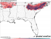
 
Last edited:
If your going to post sections from your local AFD please list which NWS office it’s from so people have an idea of what the hell they are looking at
Yeah and maybe just a link to the AFD. Thanks for posting it though, that’s about where I’d expect FFC to be at this point. They busted on the last storm as bad as the local mets.
 
Euro and NAM continue to come in a little more moist with some early overrunning precip for Wednesday morning, temps are marginal but very close for a few to a little appetizer before the main meal
ecmwf_ptype_se_84.png

ecmwf_t2m_se_84.png
I'm curious about Tuesday night into Wednesday. Looks like we are fighting a warm BL. I wouldn't be shocked up see this start showing up as more ip/snow north of 64

Sent from my SM-G955U using Tapatalk
 
I'm curious about Tuesday night into Wednesday. Looks like we are fighting a warm BL. I wouldn't be shocked up see this start showing up as more ip/snow north of 64

Sent from my SM-G955U using Tapatalk
Wow! A sneaky 4th " event"
 
Yeah and maybe just a link to the AFD. Thanks for posting it though, that’s about where I’d expect FFC to be at this point. They busted on the last storm as bad as the local mets.
Well that do have ZR Wording in my zone, off and on during Wed-Fri....
 
Still a few days out, but NWS MEG is on this mid-week storm for my neck of the woods:
An unsettled and cold weather pattern looks to set up over the Mid
South from the middle of next week into the New Years holiday
weekend. A series of disturbances should move through the region
and spread moisture over the cold airmass that should remain in
place. This may support several bouts of winter type precipitation
over the region beginning next Wednesday and continuing through
the remainder of the extended forecast period. It still remains
too early to pinpoint exact impacts or accumulations at this point
as uncertainty still remains. Regardless, a colder and moister
pattern looks increasingly likely with details worked out as move
closer in time to each event and confidence increases.
 
Gfs looked better on 6z run for sure. Cold rain here, but trending in the direction of cmc and euro
 
12z looks like it may be slightly flatter entering the pac nw

Yeah the 06z GFS was colder but really didn't respect the wedge idea as much as it should have given the strength of the parent high. If the 12z suite holds the course or is even strongee with the wedge signature, some interesting AFDs and WPC headlines are forthcoming...
 
Yeah the 06z GFS was colder but really didn't respect the wedge idea as much as it should have given the strength of the parent high. If the 12z suite holds the course or is even strongee with the wedge signature, some interesting AFDs and WPC headlines are forthcoming...
I agree. As if now, until see some changes, I think you and I are in play as well for ZR
 
By 72 hr on the CMC, the eastward displacement of the trough over the GOA gave a big kick to our s/w over the Rockies and flattened the wave relative to the last run, however (as I noted in the January discussion) w/ the stronger disturbance on the 27th, this intensified the longwave trough associated w/ our 50-50 low, allowing our s/w to dig more...
Unknown.gif
 
Back
Top