• Hello, please take a minute to check out our awesome content, contributed by the wonderful members of our community. We hope you'll add your own thoughts and opinions by making a free account!

Wintry December 23-26 2022 Winter Weather and Cold

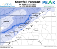
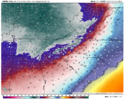
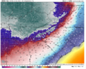
Also nam 3km was about to give us a possible snow shower with the arctic front .. that would be huge if true
That really wouldn’t shock me at all. As I said the trajectory of this cold push appears to be coming from the west southwest which cuts down on the effects of down sloping. Also it looked like the 3kNAM wants to swing a little piece of energy through with the front. Maybe a quick burst of high ratio snow.
 
Another thing that seems evident is that the short range modeling is really smashing the front through more aggressively than almost any global.
The I/40 corridor runs a risk of flash frozen sleet on roadways. Maybe down to Troutman. I think a small area is gonna have an unlucky transition when the bottom falls out then be left with temps near 19. It wouldn’t take 30mins of heavy sleet to make things bad for the rest of the day.
 
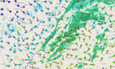
You can see the bright yellow returns on the 3km NAM blasting through I/40. I could see that narrow line of damaging sleet even further south maybe even Huntersville. All areas would quickly go below freezing before the sleet would have a chance to melt.
 
It depends on how much the winds die down. If it calms for even just a couple hours before daybreak, things could plunge in a hurry. Most of these are models are keeping a light breeze going which cuts back on radiational cooling
I'll be honest given this air mass I'm not sure we need to radiate. I think it's also possible places don't make it over 25 on Saturday. I'm really impressed with that's coming
 
1671596242975.png
1671596267291.png
I know people maybe getting impatient not seeing a storm but we are seeing massive trends to something. At H5 we’ve improved our confluence, building heights over top and creating a nice feed of CAD and cold air. And we have a closed off ULL showing up now. What have we seen this trend to? More digging to the SW with the ULL and eventual Nw trend in precip. At 150 hours, I like where we are sitting. Nice suppressed looked with adequate cold
 

Attachments

  • 1671596292884.png
    1671596292884.png
    100.8 KB · Views: 30
View attachment 127929
View attachment 127930
I know people maybe getting impatient not seeing a storm but we are seeing massive trends to something. At H5 we’ve improved our confluence, building heights over top and creating a nice feed of CAD and cold air. And we have a closed off ULL showing up now. What have we seen this trend to? More digging to the SW and eventual Nw trend. At 150 hours, I like where we are sitting. Nice suppresses looked with adequate cold


While true, it’s just too dry. Having 5 days of subzero temps isn’t the best scenario.
 
Back
Top