• Hello, please take a minute to check out our awesome content, contributed by the wonderful members of our community. We hope you'll add your own thoughts and opinions by making a free account!

Wintry Dec 8-10th Winter Storm

Seen this so many times, this thing will probably keep trending so far south that people from Montgomery to Clanton will be in the sweet spot and north Alabama will get the shaft. I wouldn’t be super pumped to be in the sweet spot at this point of the game. Trends tell us that this thing isn’t done trending one way or the other. Going to be fun to watch.
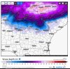
Gotta get in NAM time, then we can know placement plus precip types.
 
I bet Chris Justus won’t give those Euro totals live on the air tonight!!! lmaooo
 
The models have been showing this at least once a day for a few days now, kinda wild.
 
I bet Chris Justus won’t give those Euro totals live on the air tonight!!! lmaooo
Very few would post accumulation maps... not this far out. They should just mention that there is a likely hood of winter weather next weekend. Stay tuned to later forecasts.
 
I’m sorry but I’m about to let the :weenie: out. Euro just gave me 2+ feet!!
Let it out, go run around the outside! It’s 75 degrees and you may seriously never, ever see a run like that again, over our backyard,EVER again!
 
I kinda like this trend towards having major early December winter storms. Last year and now this year. It's nice not having to wait until February for a change !
 
The evolution trend usually is as follows :
  • South trend (D start - D 5)
  • "Suppressed to Cuba" (D 5- D 3)
  • NW trend (D 2 - D 0)
My guess is it'll be a bit further south than depicted as our final solution.

completely agree - I'm excited for a *possible* major WS for the Southeast - but, we cannot get caught up in specific precip outputs on global models - I do think east/central AL, metro ATL, and Columbia, SC need to watch closely - waiting on the NAM
 
Day dreaming about last years December storm.... . For those that say it can’t happen, even though it’s not likely.. there’s always a chance...

14 inches, Douglasville Ga December 8th 2017
 

Attachments

  • 4B593D55-6F7C-4F14-BC89-63D67A8D32F4.jpeg
    4B593D55-6F7C-4F14-BC89-63D67A8D32F4.jpeg
    1.7 MB · Views: 41
completely agree - I'm excited for a *possible* major WS for the Southeast - but, we cannot get caught up in specific precip outputs on global models - I do think east/central AL, metro ATL, and Columbia, SC need to watch closely - waiting on the NAM
Yes, waiting on the NAM.
 
Very few would post accumulation maps... not this far out. They should just mention that there is a likely hood of winter weather next weekend. Stay tuned to later forecasts.
He gave Euro totals last night that’s why I thought this was funny
 
Hopefully RDU gets a chance for an early snowfall this time. Still frustrated by last December's winter storm and my 12 hours of 33 degree rain.
 
What the cray cray is this??? Wow!!! What potential!!! Any nws offices mentioning in the long range?? I just stepped away for a few days!
 
Hopefully RDU gets a chance for an early snowfall this time. Still frustrated by last December's winter storm and my 12 hours of 33 degree rain.
I kind of felt like it wasn't going to happen for the Triangle area, so I drove to Maggie Valley!!! :)
 
fv3p_T2m_eus_34.png


FV3's Monday Highs
 
They said at the other board, GSP gets 24” with the Kuchero maps!! They are the ones that take out ice accums, I believe!!
 
Umm....that's crazy, but we see similarities between the Euro and the FV3-GFS
 

Attachments

  • Euro 12z Sunday 12-2-18.JPG
    Euro 12z Sunday 12-2-18.JPG
    146.5 KB · Views: 70
Back
Top