I agree. That thing is out to lunch. There's no way East Central NC gets 6+ inches of frozen precip from that track. We'll get an inch of slop with cold rain at best.The FV3 looks so crazy.
-
Hello, please take a minute to check out our awesome content, contributed by the wonderful members of our community. We hope you'll add your own thoughts and opinions by making a free account!
You are using an out of date browser. It may not display this or other websites correctly.
You should upgrade or use an alternative browser.
You should upgrade or use an alternative browser.
Wintry Dec 8-10th Winter Storm
- Thread starter SimeonNC
- Start date
Kylo
Member
Anyone have 12z GEFS members/snow totals?

Cad Wedge NC
Member
All but one member gives me snow here in varying amounts. I'll take that a week out anytime.
Much stronger HP out west as our wave enters CA on the Euro. Let’s she if she’ll dance
Storm5
Member
I thinks is safe to say we have an actual trend over the last 24 hours of a more southern track of the system vs previous days
Sent from my iPhone using Tapatalk
Sent from my iPhone using Tapatalk
Here is pivotal totals FWIW.
Snow
Ice
Snow
Ice
Avalanche
Member
I'll take member 12 because that makes most everyone on this board happy, plus I can drive to the NC mountains in my Jeep and have fun!!!
I thinks is safe to say we have an actual trend over the last 24 hours of a more southern track of the system vs previous days
Sent from my iPhone using Tapatalk
Let’s keep that trend going. Before you know it, this will be looking good for us! Let’s hope!
Avalanche
Member
She's a beauty Clark!! Quote Randy QuaidI thinks is safe to say we have an actual trend over the last 24 hours of a more southern track of the system vs previous days
Sent from my iPhone using Tapatalk
Ron Burgundy
Member
That...would be bad.
Round Oak Weather
Member
The FV3 on snow amounts is probably wrong but on the placement of everything I don’t think so maybe not as far into Georgia but pretty dang close
Snowflowxxl
Member
Euro looking better with the high at 120. See what it leads to down the line
Avalanche
Member
Wow, at the NC Triad with 6 inches of snow and nearly an inch of freezing rain. That my friends is crazy!!!
Avalanche
Member
If that high were to lock in.....oh my!!!!Euro looking better with the high at 120. See what it leads to down the line
ForsythSnow
Moderator
Per that site, it's all snow here.Wow at the FV3 down into Atlanta Metro. Soundings support snow on intial on set and temps warm ~850mb so would change some areas to a wintry mess of ip/zr.
View attachment 7944 View attachment 7945 View attachment 7946
Avalanche
Member
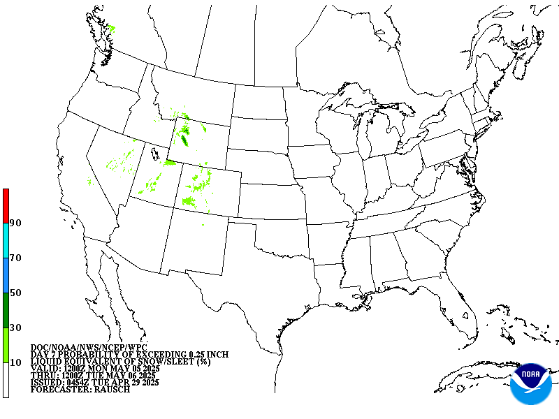
I might could have a disagreement with Brad P, but I can't trump the almighty NOAAThat's not Brad's map ....... It is from NOAA WPC 7 day winter prediction.
Euro looks fantastic so far. LP in south LA at 144
Kylo
Member
Euro south of 0z run.

Snowflowxxl
Member
Euro about to hammer some folks
Avalanche
Member
Pivotal was pretty similar to the other with Blowing Rock to Boone pounding
@DarkKnight we need the good Euro maps. WYA!?
Avalanche
Member
I know its different criteria, but that map looks like a replication to the Jan 1988
ForsythSnow
Moderator
This is going to be a Dr. YES!
Kylo
Member
South

Dr. DAMN!
That euro is close close close for many folks in Alabama. Plenty of time for this to trend in the right direction.
Snowflowxxl
Member
Incoming....
Storm5
Member
Holy hell the euro !!!
Sent from my iPhone using Tapatalk
Sent from my iPhone using Tapatalk
Kylo
Member
Not done.

What is with that crazy freezing line in central ga? That wouldn't be right would it?
Avalanche
Member
Boy this has gotten good!!! What a day so far of great model runs!!!
Avalanche
Member
Bout to do a tribal snow dance
168 hour jackpot...whoopsy daisy

GeorgiaGirl
Member
Wow, based off these maps the Euro is even close for me I think. I've been in the mode of it's not gonna happen but routing for others here but dang...
Kylo
Member
With this evolution...yes!What is with that crazy freezing line in central ga? That wouldn't be right would it?

ForsythSnow
Moderator
A Mack Special! South trend is on and it's looking great. I'm getting more excited now for this. Yes it's 6 days out and we still have to go through the cycle of disappointment but if we arrive at an upper south winter storm then bring it!
NorthGaWinter4
Member
Guys we aren’t just tracking a winter storm. I think we are tracking a major winter storm.
If you want some good entertainment head on over to the MA forum in the other board
Can’t ask for a better look than 12z Euro for Columbia SC.
SimeonNC
Member
Okay, now I'm worried about this baby getting suppressed to hell
Sent from my Z983 using Tapatalk
Sent from my Z983 using Tapatalk