Special Weather Statement
National Weather Service Peachtree City GA
333 PM EST Thu Dec 6 2018
GAZ001>009-011>016-019>025-027-030>039-041>062-066>076-078>086-
089>098-102>113-070845-
Dade-Walker-Catoosa-Whitfield-Murray-Fannin-Gilmer-Union-Towns-
Chattooga-Gordon-Pickens-Dawson-Lumpkin-White-Floyd-Bartow-
Cherokee-Forsyth-Hall-Banks-Jackson-Madison-Polk-Paulding-Cobb-
North Fulton-Gwinnett-Barrow-Clarke-Oconee-Oglethorpe-Wilkes-
Haralson-Carroll-Douglas-South Fulton-DeKalb-Rockdale-Walton-
Newton-Morgan-Greene-Taliaferro-Heard-Coweta-Fayette-Clayton-
Spalding-Henry-Butts-Jasper-Putnam-Hancock-Warren-Troup-
Meriwether-Pike-Upson-Lamar-Monroe-Jones-Baldwin-Washington-
Glascock-Jefferson-Harris-Talbot-Taylor-Crawford-Bibb-Twiggs-
Wilkinson-Johnson-Emanuel-Muscogee-Chattahoochee-Marion-Schley-
Macon-Peach-Houston-Bleckley-Laurens-Treutlen-Stewart-Webster-
Sumter-Dooly-Crisp-Pulaski-Wilcox-Dodge-Telfair-Wheeler-
Montgomery-Toombs-
333 PM EST Thu Dec 6 2018
...Wintry precipitation expected across northeast Georgia Saturday
night into Sunday...
A complex storm system will affect north and central Georgia
beginning late Friday, continuing through the weekend and
potentially into early next week. Confidence is increasing that
a period of wintry precipitation, mainly in the form of freezing
rain, will occur late Saturday night through Sunday across
northeast Georgia. The potential for snow and sleet has shifted
more into North and South Carolina.
At this time, the best chance of seeing measurable ice
accumulations will be north and east of a Homer to Gainesville to
Dawsonville line. The rain-freezing rain line could move as far
south and west as Canton to Cumming to Lawrenceville to Winder to
Athens, where a mix of rain and freezing rain is possible.
However, confidence in this happening is a bit lower at this time,
and the forecast is still subject to change based on the event
being more than 48 hours out.
Outside of the winter weather threat, across much of middle
Georgia, heavy rain Saturday into early Sunday could result in up
to 3 inches of rainfall. This will likely elevate the threat for
localized flooding or flash flooding.
Sunday night into Monday, wrap-around moisture in the colder air
behind the system could result in some light snow showers across
portions of north and central Georgia. However, being 3 to 4 days
out, confidence is low at this time.
Stay tuned to the very latest forecasts from your local media
outlets and National Weather Service office as this complex storm
system evolves over the next couple days. If you live or are
traveling across the higher elevations of northeast Georgia
especially, prepare now for winter weather conditions and
hazardous driving conditions late this weekend into early next
week.
-
Hello, please take a minute to check out our awesome content, contributed by the wonderful members of our community. We hope you'll add your own thoughts and opinions by making a free account!
You are using an out of date browser. It may not display this or other websites correctly.
You should upgrade or use an alternative browser.
You should upgrade or use an alternative browser.
Wintry Dec 8-10th Winter Storm
- Thread starter SimeonNC
- Start date
snowlover91
Member
Boom

Definitely looks a tick colder.High maybe trending a touch stronger again
B
Brick Tamland
Guest
Boom
Looking gooood.
WXinCanton
Member
Unrealistic weenie clown map thru 66

NorthGaWinter4
Member
Boy that’s a good trend for usUnrealistic weenie clown map thru 66
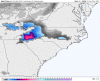
The snowfall map from NWS Greenville shows 4" in Asheville and 10" in Charlotte. I don't understand why Charlotte would get so much more. Isn't Asheville much higher in elevation ?
Same time, not including sleetUnrealistic weenie clown map thru 66
Attachments
Jessy89
Member
I don’t believe that for a momentThe snowfall map from NWS Greenville shows 4" in Asheville and 10" in Charlotte. I don't understand why Charlotte would get so much more. Isn't Asheville much higher in elevation ?
Snowflowxxl
Member
embarrisingly off for GA lolUnrealistic weenie clown map thru 66

The Carolinas are getting NAM'd!
NorthGaWinter4
Member
It’s gonna be an icy mix and that’s what the nam showedembarrisingly off for GA lol
Showmeyourtds
Member
The snowfall map from NWS Greenville shows 4" in Asheville and 10" in Charlotte. I don't understand why Charlotte would get so much more. Isn't Asheville much higher in elevation ?
**Be wary of the clown maps from Tropical Tidbits**
18z NAM does look better for us.
Ight NAM, calm down. Sheesh.
B
Brick Tamland
Guest
The Carolinas are getting NAM'd!
Wow! Big turnaround for the NAM.
Do we believe this one?
snowlover91
Member
Here's the Kuchera.

NAM looks like a FV3 map.