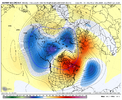
Notice how well the first week where we are getting almost purely a jet extension (previous post), actually fits with the jet extension composite (top row). (It’s a +PNA pattern).
View attachment 156133
View attachment 156134
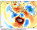
It’s not really until we get close to and beyond Christmas when we start to approach the adjacent poleward shift quadrant that the warmth really overspreads North America.
View attachment 156137
Poleward shift in the pacific jet coupled with an extension is usually how we get a big torch over N America. A jet extension
on its own actually favors colder temps in the eastern US and is the kind of pattern we’ve seen most of Dec so far.
I just want to make the distinction here clear because there’s a huge difference in sensible impacts between a jet extension
on its own and a poleward shift in the jet
on its own. I think the jet extension (while accurate in this case) takes a little too much of the blame when these kind of patterns show up & most folks (including S2S forecasters) don’t pay enough attention to the latitude of the jet, which actually matters more in regulating the EPO. It usually takes more than a pacific jet extension by itself to get these kind of warm anomalies.
View attachment 156135


