Take it while you can, could be dry post storm though I feel it’s just starting.
-
Hello, please take a minute to check out our awesome content, contributed by the wonderful members of our community. We hope you'll add your own thoughts and opinions by making a free account!
You are using an out of date browser. It may not display this or other websites correctly.
You should upgrade or use an alternative browser.
You should upgrade or use an alternative browser.
Pattern Arid August
- Thread starter SD
- Start date
JHS
Member
East of 1-77 in NC will not get a drought soon, but Alabama, Mississippi, much of Georgia, and western SC will be hit hard by drought. Expect D3-D4 in many of those areas by Sept 1.I don't think we'll have to worry about a drought for a while.
After Debby finishes her tour of the Southeast the dry weather pattern the models are currently showing might be what is needed to recover from the flooding that she will probably leave in her wake. I feel for the agricultural interests in the Eastern portions of the Southeast. After experiencing moderate to severe drought in some cases they will now have to deal with flooded fields and croplands. I hope they are covered by crop insurance.
- Joined
- Jan 23, 2021
- Messages
- 4,602
- Reaction score
- 15,197
- Location
- Lebanon Township, Durham County NC
This will almost certainly erase the drought around Florence and Marion
Dude. We just got more than a foot of rain in a couple weeks. We could bake until October and still be fine water wise.East of 1-77 in NC will not get a drought soon, but Alabama, Mississippi, much of Georgia, and western SC will be hit hard by drought. Expect D3-D4 in many of those areas by Sept 1.
JHS
Member
Not according to the drought monitor. It has moderate drought over a good bit of north GA and Alabama with a small area of severe drought in Tennessee.Dude. We just got more than a foot of rain in a couple weeks. We could bake until October and still be fine water wise.
I don't really care what it shows. I know the ground truth which is we are good and my creek has more water in it than ever in the summer.Not according to the drought monitor. It has moderate drought over a good bit of north GA and Alabama with a small area of severe drought in Tennessee.
Many areas of North and Central Alabama received 10” or more rainfall in July. We are good for awhile.East of 1-77 in NC will not get a drought soon, but Alabama, Mississippi, much of Georgia, and western SC will be hit hard by drought. Expect D3-D4 in many of those areas by Sept 1.
It's pouring its poured around 530 this morning. If you had told me in mid June the next 60 days would be like this I would have laughed until I died
JHS
Member
If the GFS is right this Sunday will be VERY nice in much of NC, SC, and parts of GA. Upper 70's to low and mid 80's and dewpoints anywhere from 48-59.
Drizzle Snizzle
Member
Is this the same GFS that says Debby will go to Alabama ?If the GFS is right this Sunday will be VERY nice in much of NC, SC, and parts of GA. Upper 70's to low and mid 80's and dewpoints anywhere from 48-59.
Drizzle Snizzle
Member
We had lows in the upper 40s in the middle of August in 2004.
Brent
Member
SnowNiner
Member
It's pouring its poured around 530 this morning. If you had told me in mid June the next 60 days would be like this I would have laughed until I died
Starting to think the same phenomenon that's causing our warm winters makes us abnormally wet all year as well. I bet we stay above normal precip this summer. Could be wrong though.
I told everyone in May! Lol. Wet summers is our jam now, just like warm winters. The pattern continues.
Iceagewhereartthou
Member
Drought will be the big story for many of us now. Much of the southeast may very well not see rain again this month.
It also says we bake again after this storm with maybe the hottest temps we have had so far.
Edit: The regular Euro has us baking, the AI Euro is not as hot, but both look dry after Debby.
Shetley, I have to ask. Why do you post so many of these drought and heat apocalyptic posts when they NEVER come close to verifying? Every year it's the same posts and they are so out there it's silly. I truly do think you're a great member and post some good and insightful stuff but your heat and drought posts make no sense. Where does this come from?East of 1-77 in NC will not get a drought soon, but Alabama, Mississippi, much of Georgia, and western SC will be hit hard by drought. Expect D3-D4 in many of those areas by Sept 1.
https://www.wral.com/story/degrees-...hind-temperatures-taking-off-at-rdu/21521863/
I'm not certain if I should post this link here but this is an interesting story about the KRDU temperature sensor controversy and its higher readings than surrounding stations during the heat wave earlier this summer.
I'm not certain if I should post this link here but this is an interesting story about the KRDU temperature sensor controversy and its higher readings than surrounding stations during the heat wave earlier this summer.
I complained so many times to KFFC about KATL's sensor the past few years, it was almost harassment. This year it has been far better. Temperature swings of four degrees in five minutes late in the afternoon is not acceptable for any professional weather station.https://www.wral.com/story/degrees-...hind-temperatures-taking-off-at-rdu/21521863/
I'm not certain if I should post this link here but this is an interesting story about the KRDU temperature sensor controversy and its higher readings than surrounding stations during the heat wave earlier this summer.
Brent
Member
Our average high starts to drop tomorrow...
Drizzle Snizzle
Member
I think technically Tulsa’s average high peaked on July 31 at 94.7 and tomorrow it will be down to 94.4. The average high went from 94.7 on 7-31 to 94.6 on 8-01.Our average high starts to drop tomorrow...
Brent
Member
JHS
Member
Heat is coming back as soon as Friday for many of us. Look for heat advisories to be coming back soon.
Drizzle Snizzle
Member
It’s 95 degrees here and you telling me the heat comes back on Friday ?Heat is coming back as soon as Friday for many of us. Look for heat advisories to be coming back soon.
Brent
Member
As of yesterday morning’s update I had received 10.3” from Debby. I’ve since had an additional 0.6” to give me a Debby grand total (over 3 days) of 10.9”, easily the largest amount from a single event here since Matthew of Oct 7-8, 2016.
Together with the 10” I got 7/19-8/3 from PM convection, I’ve received 20.9” during just the 20 day period of 7/19-8/7. Thus, any possible heavy rains from tropical or other during the next few weeks could be extra problematic.
Together with the 10” I got 7/19-8/3 from PM convection, I’ve received 20.9” during just the 20 day period of 7/19-8/7. Thus, any possible heavy rains from tropical or other during the next few weeks could be extra problematic.
Iceagewhereartthou
Member
Mid 70s for Caesar's Head next week. Not too shabby for first half of Aug! 
Sunday
Sunny, with a high near 78.
Sunday Night
Partly cloudy, with a low around 60.
Monday
A 30 percent chance of showers and thunderstorms after 2pm. Mostly sunny, with a high near 75.
Monday Night
A 30 percent chance of showers and thunderstorms before 8pm. Partly cloudy, with a low around 61.
Tuesday
A 40 percent chance of showers and thunderstorms. Mostly sunny, with a high near 76.
Tuesday Night
A 30 percent chance of showers. Partly cloudy, with a low around 61.
Wednesday
A 30 percent chance of showers. Mostly sunny, with a high near 75.
Wednesday Night
A 30 percent chance of showers. Partly cloudy, with a low around 61.
Thursday
A chance of showers and thunderstorms. Mostly sunny, with a high near 75.
Brent
Member
Drizzle Snizzle
Member
Too bad you will be near 100 again on Tuesday.For August 10th that's nearly the coolest highs we've ever had on Saturday. I haven't found many days cooler even later in the month View attachment 149748
Brent
Member
Too bad you will be near 100 again on Tuesday.
Yeah but it's August. By far our worst month for heat unfortunately
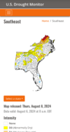
Im in yellow on that map released Aug 8th. Mby has had almost 20 inches qpf since July 4th. Almost half my annual Rainfall. Lol
MamaJen
Member
I’m in yellow in NW Georgia, and unfortunately my area hasn’t received a single drop of rain from Debbie or anything else since then. Feels like when the next map comes out, there will be a vast sea of white, with one tiny square of orange centered right over my house. lol.
- Joined
- Jan 5, 2017
- Messages
- 3,774
- Reaction score
- 5,985
Rain chances are gone until third week in August it appears. We will be orange again by then.I’m in yellow in NW Georgia, and unfortunately my area hasn’t received a single drop of rain from Debbie or anything else since then. Feels like when the next map comes out, there will be a vast sea of white, with one tiny square of orange centered right over my house. lol.
Brent
Member
Downeastnc
Member
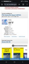
Suns out here it's warmDon't think I have ever seen a 100 heat index with overcast skies and a temp of 84....
View attachment 149812
Downeastnc
Member
Suns out here it's warm
Yeah sun here would be unbearable..
snowc
Member
Same here, with more storms?


