Euro looking really nasty for the weekend particularly for south central AL/GA. I think the analogs I like are 3/03/19 and 3/15/08. GFS is the most south and least threat, while the UKmet splits the difference. The CMC is close to the Euro.
-
Hello, please take a minute to check out our awesome content, contributed by the wonderful members of our community. We hope you'll add your own thoughts and opinions by making a free account!
You are using an out of date browser. It may not display this or other websites correctly.
You should upgrade or use an alternative browser.
You should upgrade or use an alternative browser.
April 23-25th Severe Threat
- Thread starter Arcc
- Start date
cd2play
Member
Isn’t 3/15/08 the one that brought the Atlanta tornado during the SEC tournament?
Isn’t 3/15/08 the one that brought the Atlanta tornado during the SEC tournament?
Taking the Euro verbatim, 3/15 is the better analog. AL may just squeeze by before the best low level wind shear passes and surface winds veer. This also happened on 3/15.

Yikes
NBAcentel
Member
4/23/20 is not a bad analog either, very similar synoptic scale pattern with a very similar SE Canada vortex, this setup screams the more south the more severe wx, especially towards the gulf coast
FYI in winter this is probably a winter storm


FYI in winter this is probably a winter storm
NBAcentel
Member
If I was a betting man, I’d bet this setup ends up further south then modeled, impressive double barrel jet structure with divergence over the SE with lots of quasigeostrophic forcing
Basically probably gonna be lots of junk that forces some sort of effective warm front/stationary boundary south
Basically probably gonna be lots of junk that forces some sort of effective warm front/stationary boundary south
If I was a betting man, I’d bet this setup ends up further south then modeled, impressive double barrel jet structure with divergence over the SE with lots of quasigeostrophic forcing
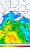
Basically probably gonna be lots of junk that forces some sort of effective warm front/stationary boundary south View attachment 82041
So you're thinking this will be more of a Gulf Coast threat? Anyway we can get a little something something? I mean I'd be okay with some elevated storms. Just give me some rain.
cd2play
Member
North of the WF will still have hailers, and lightning /thunder.If I was a betting man, I’d bet this setup ends up further south then modeled, impressive double barrel jet structure with divergence over the SE with lots of quasigeostrophic forcing
Basically probably gonna be lots of junk that forces some sort of effective warm front/stationary boundary south View attachment 82041
Certainly has the feel of a late winter/early spring setupIf I was a betting man, I’d bet this setup ends up further south then modeled, impressive double barrel jet structure with divergence over the SE with lots of quasigeostrophic forcing
Basically probably gonna be lots of junk that forces some sort of effective warm front/stationary boundary south View attachment 82041
NBAcentel
Member
Yeah I think some elevated storms are possible in NC, SC however tho is close to getting some surface based stuff especially down towards Columbia-southSo you're thinking this will be more of a Gulf Coast threat? Anyway we can get a little something something? I mean I'd be okay with some elevated storms. Just give me some rain.
NBAcentel
Member
It’s funny because that setup last year I was mentioning was a cold rain for us ?Certainly has the feel of a late winter/early spring setup
Yeah I think some elevated storms are possible in NC, SC however tho is close to getting some surface based stuff especially down towards Columbia-south
Given Columbia isn't too far from CLT, I would say this still bears some watching. Those WF boundaries and be quite sneaky and can jolt north quickly as we've seen the the past.
NBAcentel
Member
I think the potential around late April tho has a better chance of a more classic plains-OH valley/Dixie/Carolinas/mid atl type progression, but if we have something in the Atlantic moisture return might be a problem
Damn already a hail producing storm in NE NC ... that must be the hot spot this year ? a @metwannabe classic
opps wrong thread
opps wrong thread
NBAcentel
Member
Geez 
JHS
Member
Atlanta actually had that tornado during the evening of 3/14/2008. Then the big system came on the 15th.Isn’t 3/15/08 the one that brought the Atlanta tornado during the SEC tournament?
Euro looks mostly the same. Should junk convection not overcrowd, the southern third of AL and GA will have a rough day.
flash density maps?
NBAcentel
Member
Say please ?flash density maps?
PLEEEEEEASE...LOLSay please ?
NBAcentel
Member


Not gonna lie, that area, wherever it sets up scares me.
Attachments
You can force a HSLC line for us in this setup. Realistically this is a setup I'd prefer to cold rain, the potential for widespread wind damage is too high and I like power

B
Brick Tamland
Guest
Been like that my way for 90% of the time with any severe threats the last decade.
Z
Zander98al
Guest
Maybe a dumb question. But what is so worrying about the potential severe weather coming up. I really haven't looked I know that a low pressure system is gonna track near north alabama though.
B
Brick Tamland
Guest
Alabama will probably be in the game again.
Yep always seems like.Alabama will probably be in the game again.
Z
Zander98al
Guest
12z euro. Has the low pressure system almost sub 1000mbs with a negative tilt. Late April instability will be there. Don't really remember any decent outbreaks in southern alabama since I've been alive other than the one with the enterprise and then the Lee county outbreak. Mesoscale models are right on the cusp of being in range.
Z
Zander98al
Guest
Also of note wind fields are almost screaming around 850mb in south Alabama according to the euro with 80kts being shown.
NBAcentel
Member
Euro doesn’t look like much of a tornado threat but rather a hail threat with unidirectional flow and long straight Hodographs/large SBcape 


Z
Zander98al
Guest
How do you get the euro with instability? Is there another website that has the euro other than tropical tidbits?Euro doesn’t look like much of a tornado threat but rather a hail threat with unidirectional flow and long straight Hodographs/large SBcape View attachment 82072View attachment 82073View attachment 82074
Oh yeh, but you have to pay for it.How do you get the euro with instability? Is there another website that has the euro other than tropical tidbits?
Welp. I guess RIP to this event. I’ll be happy with the heavy rain. At my location in Lexington, SC we have had 0.07 for April. We need the rain.
Z
Zander98al
Guest
Don't look now weather weenies, the nam looks nasty for south alabama. Currently working so can't really dive in but got a quick look
Z
Zander98al
Guest
Forecast sounding for south Alabama 
@Myfrotho704_ maybe some thunder Saturday morning got a little elevated cape 
@Myfrotho704_ maybe some thunder Saturday morning got a little elevated cape View attachment 82115
Can the dates on this thread be extended to include 4/23?

