I think its just site specificWhy does sometimes that little box says TOR and sometimes it spells out the whole word, Tornado?
-
Hello, please take a minute to check out our awesome content, contributed by the wonderful members of our community. We hope you'll add your own thoughts and opinions by making a free account!
You are using an out of date browser. It may not display this or other websites correctly.
You should upgrade or use an alternative browser.
You should upgrade or use an alternative browser.
Pattern Ablazing August
- Thread starter SD
- Start date
Z
Zander98al
Guest
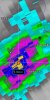
My guess is an explosion at the mine. Startled all the birds and they flew off in each direction.It looks like an explosion. I would think wildlife wouldn't move with the same pace in all directions. But who knows?
Sent from my moto g power using Tapatalk
Downeastnc
Member
It looks like an explosion. I would think wildlife wouldn't move with the same pace in all directions. But who knows?
They do really big demo's to break new ground from time to time....
My guess is an explosion at the mine. Startled all the birds and they flew off in each direction.
Sent from my moto g power using Tapatalk
This makes sense the bigger returns locally are birds etc.....but the ring itself is probably a shockwave, especially given the atmospheric conditions this morning.....
Shaggy
Member
It looks like an explosion. I would think wildlife wouldn't move with the same pace in all directions. But who knows?
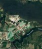
Yeah no doubt it originated at the mine. Here's an overview and it's clearly from the mine. There are big lakes there so the bug hatch idea that @SD said can't be ruled out. The pattern looks like shockwave to me. I've fished around that area my entire life and can't ever remember a demolition when inwas down there, not one that I heard anyways.
Attachments
BHS1975
Member
NBAcentel
Member
Looks like Brad p is going with the warmer side of guidance
cd2play
Member
The radar came down with the mumps... I mean, COVIDBirds
Sent from my iPhone using Tapatalk
NBAcentel
Member
Typically you see bats/birds make that same sort of roost ring in many other states
Here’s a older one
Here’s a older one
Fog lifting? Nuke? Everybody ok down there?This I s time sensitive. Does anybody want to take a guess at what this weird anomaly is on the Morehead City radar it looks like a ring moving out
Newport/Morehead City, NC
www.weather.gov
Looks like Brad p is going with the warmer side of guidance
He is but even he has come down a little… forecasting 94-95 yesterday
It recognizes the user, some know what Tor means, other's it has to spell it out for them.Why does sometimes that little box says TOR and sometimes it spells out the whole word, Tornado?
Looks like Brad p is going with the warmer side of guidance
It looks good based on what guidance is out there. The Euro and EPS are big on lowering dews and heating the I85 corridor while keeping the US1/95 corridors with higher dews and more average daytime highs. You can see the piedmont trough sharpening each afternoon on the Euro and as the week goes along it gets deeper and slightly farther east. Something to watch this week I've never paid enough attention to really see how the temp patterns play out when you really sharpen the piedmont trough and if it does heat the I85 corridor more than eastern areas


Last edited:
LickWx
Member
I’ll take those dews in a heart beat.It looks good based on what guidance is out there. The Euro and EPS are big on lowering dews and heating the I85 corridor while keeping the US1/95 corridors with higher dews and more average daytime highs. You can see the piedmont trough sharpening each afternoon on the Euro and as the week goes along it gets deeper and slightly farther east. Something to watch this week I've never paid enough attention to really see how the temp patterns play out when you really sharpen the piedmont trough and if it does heat the I85 corridor more than eastern areas
View attachment 87697
View attachment 87698
View attachment 87700
View attachment 87699
NBAcentel
Member
I’ll take the higher heat !
Shaggy
Member
Typically you see bats/birds make that same sort of roost ring in many other states
Here’s a older one
Looks similiar really. Thought it was interesting but we will probably never know for sure.
Z
Zander98al
Guest
Reached a cool 69 degrees this morning. Felt good, was a bit muggy though. But that's the usual in the summer
Sent from my moto g power using Tapatalk
Sent from my moto g power using Tapatalk
Me gusta

Downeastnc
Member
Got to 63 this morning....hi res models look rough tomorrow, ditches are still full from the other day, yard was still a little squishy etc.....hopefully we get through tomorrow with not much rain.
B
Brick Tamland
Guest
Get out of clouds and rain tomorrow . That seems hard to do if you ask me . Especially further north , probably you make it out but @Brick Tamland doesn’t and we hear about south and east action and it only storms when there is no watch etc.

NBAcentel
Member
????????

Decent training and a solid pivot point = some localized big time totals tomorrow .. HRRR has wanted it to be somewhere in central NC .. but we all know exact location won’t be known until we nowcast .. regardless someone is seeing a flash flood warning
LickWx
Member
That precip max looks perfectly placed over Jordan lake and apex ... don’t tell @AvalancheDecent training and a solid pivot point = some localized big time totals tomorrow .. HRRR has wanted it to be somewhere in central NC .. but we all know exact location won’t be known until we nowcast .. regardless someone is seeing a flash flood warningView attachment 87708
- Joined
- Jan 5, 2017
- Messages
- 3,810
- Reaction score
- 6,066
So far, August is not ablazing.
Dang Rah NWS going all in on tomorrow (this was from the morning update)
Rainfall totals for late tonight and Saturday will also likely need
a (possibly significant) upward adjustment with the afternoon
forecast package, with a narrow swath of 2-3" probable, locally
around 4", along and on the immediate cool side of the retreating
coastal front and frontal wave during that time.

Going to be in Burlington tomorrow woo hoo
JHS
Member
Mostly a big miss back west. I can not imagine that little blob off by itself in upstate SC being right because i would get around 4 inches of rain if it was. The band from CLT and northeast is probably legit though.
Bannerdude
Member
2" radar estimates east of Chapel Hill near Jordan Lake already and its been pouring here too. Jordan Lake sink zone cancel.

Shaggy
Member
No surprise here but its pouring in Pitt County again
Shaggy
Member
Flood advisory now up as 1-3 have already fallen and an additional 1-2 more is possible. Looks like that 0z run of the hrrr that had widespread 2-4 with a 5.5 inch lollipop over the county was pretty spot on.
And this is before all the rain coming tonight and tomorrow .. there will be flash flooding I believe for some areas in the next 24 hours2" radar estimates east of Chapel Hill near Jordan Lake already and its been pouring here too. Jordan Lake sink zone cancel.
View attachment 87736
Shaggy
Member
Heaviest totals missed the airport and official station again. This area of southern Pitt just southeast of my house has been getting crushed this summer. Pgv is a surplus of +15 and this area is several inches ahead of that. Just crazy how much rain we've been getting.
Attachments
NBAcentel
Member
My area aka the rain forest 
Not confidence-inspiring.

LickWx
Member
Any lightning yet or just plain rain so far ?My area aka the rain forest View attachment 87741
NBAcentel
Member
Just rain but the short range models don’t show any real/more robust convection until 3am and past thatAny lightning yet or just plain rain so far ?
Someone is getting a flash flood that’s for sure … I can’t wait to see the radar blossom and hear the heavy rain falling outside my window and if we’re really lucky we can maybe stay in the 70s tomorrow.. i dont know about The whole severe threat I would assume a severe gusts will be very few and far between 
LickWx
Member
Gl you staying up or waking up early ?Just rain but the short range models don’t show any real/more robust convection until 3am and past that
JHS
Member
The same places over and over with the rain. We need rain west of I-77, not EAST of there again. Central and eastern NC has had enough.
NBAcentel
Member
Gonna be Waking up earlyGl you staying up or waking up early ?