F-5
Member
McLaurin is home to a decent sized military base, Camp Shelby.
NOT IF BUT WHEN THIS DOES START AGAIN IT WILL BE BADMesoanalysis shows that helicity is increasing in and around the supercell. Sbcape 2000+, LLLRs 6-7 and LI’s -7 to -8 all along the path. This is the type storm I feared would happen farther north.
You think this cell maybe cycling some?Mesoanalysis shows that helicity is increasing in and around the supercell. Sbcape 2000+, LLLRs 6-7 and LI’s -7 to -8 all along the path. This is the type storm I feared would happen farther north.
Tightening back up now. ?Tornado looks to weaken abit God I hope so.
Why is there a big blotch in the middle? Is it become very broad or is radar having a hard time picking up wind speeds?View attachment 39899
It could drop a big one anytime though. The mesocyclone on that supercell is MASSIVE.Still broad rotation but debris signature about gone
I know, that's what scares me. Hopefully this can pass before that happensIt could drop a big one anytime though. The mesocyclone on that supercell is MASSIVE.
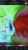
Good news is that the tornado will start hitting alot of wooded areas. That usually disrupts tornadoes and weakens it. Will see thoRotation starting to organize some. I think a tornado could form in that general location View attachment 39900
Off topic, but ive found a city that i never knew about. Called "state line" right by MS and AL state line this tornado is heading near the "state line" not the time for a corny joke but is heading near the state line
Good news is that the tornado will start hitting alot of wooded areas. That usually disrupts tornadoes and weakens it. Will see tho
Not quite, the Hackleburg tornado ate up miles of forest before descending upon Phil Campbell. Woods also didn’t bother it around Mt Hope.
This is a common misconception. They may not form as often in mountainous areas, but they can still strike and even go up and over mountains. In some cases local topography can accelerate winds in parts of a tornado.Mountains disrupt tornadoes correct? You never hear of western NC getting many Tornadoes.
Sent from my iPhone using Tapatalk
UPLOAD IT TO YOUTUBE THEN COPY AND PASTE THE URL IN THE REPLY BOX ON HEREIf I can post my video I will. The possible tornado came 20 miles south of me and it got rough at my place.
If I can post my video I will. The possible tornado came 20 miles south of me and it got rough at my place.

That’s brutal. Probably widespread 70-90mph gusts in that. There’s going to be damage.Significant wind damage likely with this
That’s brutal. Probably widespread 70-90mph gusts in that. There’s going to be damage.


Microburst?..those can get interesting. Those straight line 100mph winds are no joke. Had one here about 11-12 years ago and it was terrifying. Laid 100+ year old Oak trees down facing the same direction all throughout town. Pretty wildSignificant wind damage likely with this View attachment 39904