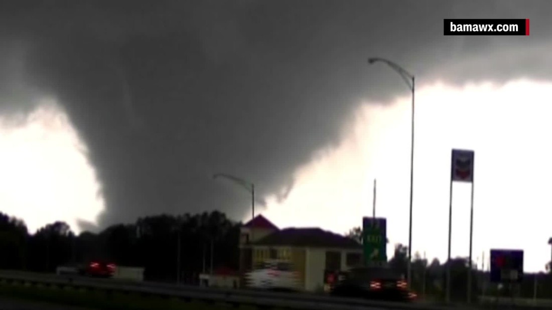
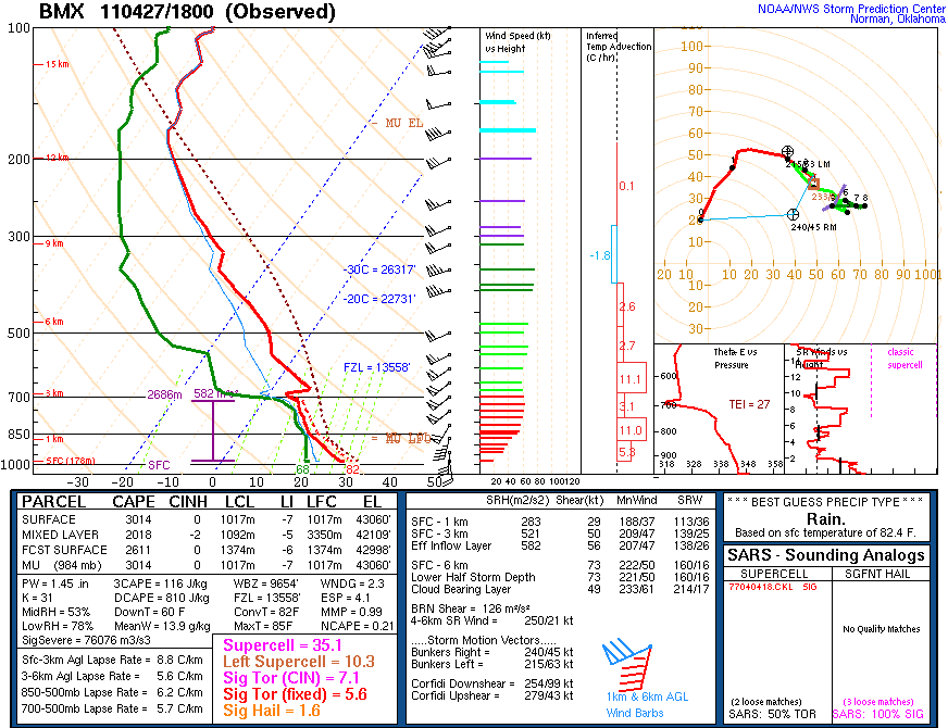
I hope that we don't see #2.
-
Hello, please take a minute to check out our awesome content, contributed by the wonderful members of our community. We hope you'll add your own thoughts and opinions by making a free account!
You are using an out of date browser. It may not display this or other websites correctly.
You should upgrade or use an alternative browser.
You should upgrade or use an alternative browser.
4/11/20 - 4/13/20 Severe Weather Outbreak
- Thread starter Webberweather53
- Start date
-
- Tags
- severe weather tornadoes
Darklordsuperstorm
Member
B
Brick Tamland
Guest
Some really nasty analogs in there including April 27 2011. That was a bad day.
That or a April 16, 2011 repeat would be awful.
Snowflowxxl
Member
The 12z NAM had loaded gun soundings all over the place.
Dawgdaze22
Member
The 12z NAM had loaded gun soundings all over the place.
Georgia too?
Sent from my iPhone using Tapatalk
thanksgivingbrown
Member
Yes. It could extended well into the Carolinas as wellGeorgia too?
Sent from my iPhone using Tapatalk
GeorgiaGirl
Member
Dawgdaze22
Member
What does the STP normally have to be to indicate a good chance of tornadoes? I guess I’m asking how far above average are those values?
Sent from my iPhone using Tapatalk
Snowflowxxl
Member
It just lets you know the environment is ripe for Tornadoes. Those values are pretty rare in GA, esp since it will be in the night.What does the STP normally have to be to indicate a good chance of tornadoes? I guess I’m asking how far above average are those values?
Sent from my iPhone using Tapatalk
Dewpoint Dan
Member
Are there any similarities between this system and the April 2011 system ?
Snowflowxxl
Member
Both are occurring in April.Are there any similarities between this system and the April 2011 system ?
Dawgdaze22
Member
Both are occurring in April.

Is this worse?
Sent from my iPhone using Tapatalk
farleydawg792
Member
Values higher than one (1) tend to be more supportive. Across NGA at 06z-09z on Monday you see values from 3 to 9. This doesn't mean a tornado is 3 to 9 times more likely, but it does mean if super cell storm initiation does occur, the combination of buoyancy and wind shear would support larger tornadoes.What does the STP normally have to be to indicate a good chance of tornadoes? I guess I’m asking how far above average are those values?
Sent from my iPhone using Tapatalk
Dewpoint Dan
Member
James Spann said of course this wont be worse than April 2011. That was a generational event. He is very confident this wont be on the scale of that event.Is this worse?
Sent from my iPhone using Tapatalk
Dawgdaze22
Member
Values higher than one (1) tend to be more supportive. Across NGA at 06z-09z on Monday you see values from 3 to 9. This doesn't mean a tornado is 3 to 9 times more likely, but it does mean if super cell storm initiation does occur, the combination of buoyancy and wind shear would support larger tornadoes.
Cool thanks for the explanation!
Sent from my iPhone using Tapatalk
B
Brick Tamland
Guest
James Spann said of course this wont be worse than April 2011. That was a generational event. He is very confident this wont be on the scale of that event.
I think that is really premature to say.
Dawgdaze22
Member
I think that is really premature to say.
And what makes you say that?
Sent from my iPhone using Tapatalk
Cadi40
Member
I wouldn’t call this a generational event, however a possibly historic outbreak that we have not seen in quite a few years.
BHS1975
Member

Tornadoes in the Southeast are getting worse -- and they're often the deadliest - CNN
In recent years, scientists have noticed an increased frequency of tornadoes in the Southeast, carving a deadly path in what's called Dixie Alley.
Sent from my iPhone using Tapatalk
B
Brick Tamland
Guest
And what makes you say that?
Sent from my iPhone using Tapatalk
Because all the perimeters are there for it to be just as bad. We don't know how it will turn out yet. But to say it can't happen again because that happened not too long ago in 2011 is a silly reason to discount that it could happen again.
farleydawg792
Member
Item Replacement
noaa.maps.arcgis.com
Excellent website for the April 2011 event.
Snowflowxxl
Member
The parameters for 4/27/2011were better than this event. That event had no flaws.Because all the perimeters are there for it to be just as bad. We don't know how it will turn out yet. But to say it can't happen again because that happened not too long ago in 2011 is a silly reason to discount that it could happen again.
Darklordsuperstorm
Member
If I had to guess I would say that the current area that is hatched outside of the current moderate risk will be upgraded to moderate tomorrow and the area that is currently moderate will be upgraded to high.
BHS1975
Member
Pretty high risk for 8am

Sent from my iPhone using Tapatalk

Sent from my iPhone using Tapatalk
Have any of you guys in the CLT and surrounding areas seen ------------- this tweaked a couple of days out?
Dewpoint Dan
Member
To say there is no way this will be as bad as April 2011 because that was a generational event is not professional IMO. At least list reasons as to why it wont be as bad.Because all the perimeters are there for it to be just as bad. We don't know how it will turn out yet. But to say it can't happen again because that happened not too long ago in 2011 is a silly reason to discount that it could happen again.
Even with STP (signifigant tornado perimeter) values around 1-3 can produce good tornadoes but when values start reaching 4-8+ values .. you're talking about the atmosphere easily being able to produce tornadoes and keep them sustained for a whileWhat does the STP normally have to be to indicate a good chance of tornadoes? I guess I’m asking how far above average are those values?
Sent from my iPhone using Tapatalk
RollTide18
Member
To say there is no way this will be as bad as April 2011 because that was a generational event is not professional IMO. At least list reasons as to why it wont be as bad.
At the same time, to say this will be as bad as April 27th isn't professional either.
While the setup for April 27th was damn near perfect for an outbreak, there were also a lot of small scale features, such as boundaries being set up from one of the most violent QLCS that Alabama has ever seen that had came through earlier that morning. It's appears that this will be a bad system but we just won't know how bad it will really get until that morning or when the event gets underway.
Z
Zander98al
Guest
Spann says he wouldnt be suprised if a high risk is issued for part of alabama and the moderate expanded ?
These soundings are scary, it’s as simple as that, Normally the NAM May over do it but even taking some things off these soundings, there still scary
Soundings from MS/ALView attachment 38871View attachment 38872soundings from NC/SCView attachment 38873View attachment 38874
That second sounding is pretty impressive.
Ok guys let’s stay on topic. Thanks
Shaggy
Member
Pretty high risk for 8am

Sent from my iPhone using Tapatalk
See I've kind of let my guard down based on timing. Mods dont really keep the line that intense as it crosses central and eastern NC and historically early morning tornado outbreaks are rare.
Guess I'll watch it a while longer and see if it slows down timing wise.
To say there is no way this will be as bad as April 2011 because that was a generational event is not professional IMO. At least list reasons as to why it wont be as bad.
Well here is the sounding of this event per the the 12z NAM vs April 27 at BMX. Do a little comparing of the two and you will see there really is no comparing the two.

Attachments
Z
Zander98al
Guest
Also worth noting a outflow boundary was positioned from tuscaloosa through birmingham which aided in intensity for the tuscaloosa/birmingham tornadoWell here is the sounding of this event per the the 12z NAM vs April 27 at BMX. Do a little comparing of the two and you will see there really is no comparing the two.

bingcrosbyb
Member
Also worth noting a outflow boundary was positioned from tuscaloosa through birmingham which aided in intensity for the tuscaloosa/birmingham tornado
The big outflow boundary was the one that sat across North AL, MS and GA. The Hackleburg, Smithville and Rainsville tornadoes formed off of it. That said it likely saved much of TN.
Dewpoint Dan
Member
I wonder why the colors dip down further south in North GA. Is there going to be a wedge in place ?12z 3km NAM STP valid Sunday afternoon. I don’t ever recall seeing such a large area off the chart.
Dawgdaze22
Member
12z 3km NAM STP valid Sunday afternoon. I don’t ever recall seeing such a large area off the chart.
Does anyone have this for Sunday night ?
Sent from my iPhone using Tapatalk
12z 3km NAM STP valid Sunday afternoon. I don’t ever recall seeing such a large area off the chart.
They must have changed something as 0-1km EHI is from 2-4 in that area which is high, but not ungodly.


