• Hello, please take a minute to check out our awesome content, contributed by the wonderful members of our community. We hope you'll add your own thoughts and opinions by making a free account!

Tropical 2025 Tropical Thread

For the first time in weeks, the latest Euro Weeklies actually has a week forecasted to be slightly above the 2005-2024 average in the ATL basin. It’s for Aug 11-17:

It has that week at 110% of 2005-24 avg:
IMG_4067.png

Just two runs ago it had only 60% of 2005-24 avg:
IMG_4068.png

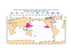
The highlighted areas have the highest chance for something nearby that week:

IMG_4069.png
 

Attachments

  • IMG_4069.png
    IMG_4069.png
    56.1 KB · Views: 8
For the MDR lemon that’s been in the TWOs for a bit:


Tropical Weather Outlook
NWS National Hurricane Center Miami FL
800 PM EDT Sat Jul 19 2025

For the North Atlantic...Caribbean Sea and the Gulf of America:

Central Tropical Atlantic:
A tropical wave located about 1000 miles west-southwest of the
Cabo Verde Islands is producing disorganized showers and
thunderstorms. Environmental conditions appear marginally conducive
for gradual development during the next few days as the system moves
westward to west-northwestward around 10 mph. By the middle of next
week, environmental conditions are forecast to become unfavorable
for further development.
* Formation chance through 48 hours...low...10 percent.
* Formation chance through 7 days...low...20 percent.

$$
Forecaster Bucci
 
Shear going to kill it if it does form.

Thanks RC. Also, though climo says MDR chances start rising notably in late July, it’s still usually inactive this early based on looking back decades. This is despite recent years possibly giving a more bullish impression.

Although warm, it currently isn’t as warm in that region as the prior two summers.

Yeah we still got a month to go before the real season starts imo

Not to say we can't get something but I'm talking about a legit storm
 
Regarding Invest 94L in the MDR: 8PM TWO sounds significantly more bullish than prior ones though the % rose only from 10 to 20:

Tropical Weather Outlook
NWS National Hurricane Center Miami FL
800 PM EDT Sun Jul 20 2025

For the North Atlantic...Caribbean Sea and the Gulf of America:

Central Tropical Atlantic (AL94):
A small area of low pressure has developed from a tropical wave in
the Central Tropical Atlantic, about 900 miles east-southeast of the
Lesser Antilles. Shower and thunderstorm activity has recently
become more concentrated near the center, and environmental
conditions are generally favorable for some additional development
over the next day or so while the system moves west-northwestward at
10 to 15 mph. By the middle of this week, environmental conditions
are forecast to become unfavorable for further development.
* Formation chance through 48 hours...low...20 percent.
* Formation chance through 7 days...low...20 percent.

$$
Forecaster Papin

IMG_4101.png
 
So, this Andy Hazelton tweet is sort of agreeing with what Eric Webb just had said about an expected quiet August into early Sept. Note, however, that Andy said “I’m kinda of the same opinion that August may be quiet in the Atlantic”, which isn’t a forecast since August “may be quiet” in any year. A forecast would say something like “August will be quiet”, “I expect August to be quiet”, or “August will likely be quiet”.

 
Last edited:
So, this Andy Hazelton tweet is sort of agreeing with what Eric Webb just had said about an expected quiet August into early Sept. Note, however, that Andy said “I’m kinda of the same opinion that August may be quiet in the Atlantic”, which isn’t a forecast since August “may be quiet” in any year. A forecast would say something like “August will be quiet”, “I expect August to be quiet”, or “August will likely be quiet”.


JB disagrees

 
The euro had a couple decent looking waves traverse the MDR but nothing going yet. Some signs of life though for sure
I sure hope Aug is active. If we have yet another dead season till mid/late Sept then NC is out of the game as the winter pattern will have arrived and anything in the ATL recurves east of Bermuda.
 
The wave train is about to start leaving the station off the African coast soon but conditions are not as favorable for Atlantic development as in recent years. So far, everything that has developed has been weak in intensity. Saharan dust has lessened over the Atlantic but wind shear continues to be an issue. Water temperatures are also cooler than ideal over the Atlantic for intensification of anything that come across the Atlantic. Things will start picking up in August as far as disturbances to work with but as of now it looks like there is little potential for anything to blow up into a strong tropical system.
 
From JB today fwiw: he likes to look at Euro AI ensemble members (ever since that product became available earlier this summer) vs EPS/GEFS and he’s also considering EPS’ MJO forecast: this period is before the increasingly active week that yesterday’s Euro Weeklies showed

“Day 15 06 z AI ends like this with a trough in the Tennessee Valley.

and a spray of cyclones suggesting an east coast impact threat

AI VV patterns in the 10-15 are bullish for the tropics

which would mean a stronger rotation into phases 8,1,2,3

more so than the euro ensemble”

IMG_4143.png
 
Last edited:
From JB today fwiw: he likes to look at Euro AI ensemble members (ever since that product became available earlier this summer) vs EPS/GEFS and he’s also considering EPS’ MJO forecast: this period is before the increasingly active week that yesterday’s Euro Weeklies showed

“Day 15 06 z AI ends like this with a trough in the Tennessee Valley.

and a spray of cyclones suggesting an east coast impact threat

AI VV patterns in the 10-15 are bullish for the tropics

which would mean a stronger rotation into phases 8,1,2,3

more so than the euro ensemble”

View attachment 173633
There is a correlation with the MJO moving into P2 and a pickup in tropical activity in the Atlantic. Plus, if it moves slowly rather than rapidly, that is even more favorable. So it looks like we're heading in that direction. We'll probably see things come to life over the next 10-14 days. The MJO won't cure the ice water in the Caribbean, though.
 
Back
Top