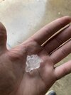
DVD Sized Hail???!!!

WUUS54 KLUB 252158
SVRLUB
TXC219-279-252300-
/O.NEW.KLUB.SV.W.0071.250425T2158Z-250425T2300Z/
BULLETIN - EAS ACTIVATION REQUESTED
Severe Thunderstorm Warning
National Weather Service Lubbock TX
458 PM CDT Fri Apr 25 2025
The National Weather Service in Lubbock Texas has issued a
* Severe Thunderstorm Warning for...
North central Hockley County in northwestern Texas...
Southern Lamb County in northwestern Texas...
* Until 600 PM CDT.
* At 457 PM CDT, a severe thunderstorm was located 5 miles west of
Littlefield, moving southeast at 5 mph.
THIS IS A DESTRUCTIVE STORM FOR AMHERST AND LITTLEFIELD.
HAZARD...Softball size hail and 60 mph wind gusts.
SOURCE...Radar indicated.
IMPACT...People and animals outdoors will be severely injured.
Expect shattered windows, extensive damage to roofs,
siding, and vehicles.
* Locations impacted include...
Fieldton, Amherst, Littlefield, and Spade.
PRECAUTIONARY/PREPAREDNESS ACTIONS...
Remain alert for a possible tornado! Tornadoes can develop quickly
from severe thunderstorms. If you spot a tornado go at once into the
basement or small central room in a sturdy structure.
This is a dangerous storm. Prepare immediately for large, destructive
hail, capable of producing significant damage. People outside should
move to shelter inside a strong building, and stay away from windows.
Torrential rainfall is occurring with this storm, and may lead to
flash flooding. Do not drive your vehicle through flooded roadways.
A Tornado Watch remains in effect until 1000 PM CDT for northwestern
Texas.
&&
LAT...LON 3386 10258 3410 10248 3411 10210 3371 10224
TIME...MOT...LOC 2157Z 299DEG 6KT 3394 10242
TORNADO...POSSIBLE
THUNDERSTORM DAMAGE THREAT...DESTRUCTIVE
HAIL THREAT...RADAR INDICATED
MAX HAIL SIZE...4.00 IN
WIND THREAT...RADAR INDICATED
MAX WIND GUST...60 MPH
$$
DWK