• Hello, please take a minute to check out our awesome content, contributed by the wonderful members of our community. We hope you'll add your own thoughts and opinions by making a free account!

Severe 2025 Severe Thread

Tornado Watch likely incoming for my area soon. Been seeing a signal for some pretty big storms potentially developing in SW OK in a few hours. Could be some big time hail as well.1745873328801.png
 
Tornado Watch likely incoming for my area soon. Been seeing a signal for some pretty big storms potentially developing in SW OK in a few hours. Could be some big time hail as well.View attachment 172628
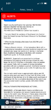
Just had one issued here! If the cap can break down this way, could be some really bad storms! IMG_0443.png
 
Haven't watched all of it but that storm is absolutely insane simply in general based off Brad Arnold's stream.

You apparently had a lot of storm chasers putting themselves in a dumb position here (right in the path).

 
Haven't watched all of it but that storm is absolutely insane simply in general based off Brad Arnold's stream.

You apparently had a lot of storm chasers putting themselves in a dumb position here (right in the path).


Conor croff was caught in that and you could tell he was.slightly shook after. Visibility was maybe 100 feet with high winds and hail
 
I’m in Tuscaloosa this evening for a family member graduating. Maybe will see a good storm!
 
Get ready for a walloping, Carolina folks!
the convective band will
increase the potential for training and risk of flash flooding. A
Flash Flood Watch was considered from Anson Co. newd through the
Triad counties; and one may ultimately become necessary based on
later observational trends.
 
First cells of the day! Not even 12pm!
RYpGuUO.jpeg
 
This area is such a magnet for spin ups IMG_4361.png
 
Good thing we didn’t get more sunshine today and things couldn’t really heat up. Could’ve been a more significant threat. Cloud cover pretty much stayed overhead all day
 
Tornado Warning for... Northwestern Pasquotank County in northeastern North Carolina... Northwestern Perquimans County in northeastern North Carolina... Eastern Gates County in northeastern North Carolina... North central Chowan County in northeastern North Carolina...

* Until 900 PM EDT.

* At 833 PM EDT, a severe thunderstorm capable of producing a tornado was located over Hobbsville, or near Ryland, moving northeast at 25 mph.

HAZARD...Tornado and quarter size hail.

SOURCE...Radar indicated rotation.

IMPACT...Flying debris will be dangerous to those caught without shelter. Mobile homes will be damaged or destroyed. Damage to roofs, windows, and vehicles will occur. Tree damage is likely.

* Locations impacted include... Sunbury, Hobbsville, Gliden, Lynchs Corner, Acorn Hill, Peach, Sign Pine, Whiteston, Sandy Cross, Hickory Crossroads, and Trotville.
 
Back
Top