HO LEE SHEET
And the DVDs are back in the forecast!
View attachment 172792
HOLY ----
...A TORNADO WARNING REMAINS IN EFFECT UNTIL 345 PM CDT FOR
SOUTHWESTERN BOLLINGER...SOUTHEASTERN WAYNE AND NORTHWESTERN STODDARD
COUNTIES...
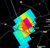
At 310 PM CDT, a severe thunderstorm capable of producing a tornado
was located near Greenville, moving east at 50 mph.
HAZARD...Tornado and softball size hail.
SOURCE...Radar indicated rotation.
IMPACT...Flying debris will be dangerous to those caught without
shelter. Mobile homes will be damaged or destroyed. Damage
to roofs, windows, and vehicles will occur. Tree damage is
likely.
This dangerous storm will be near...
Shook around 315 PM CDT.
Puxico around 325 PM CDT.
PRECAUTIONARY/PREPAREDNESS ACTIONS...
TAKE COVER NOW! Move to a basement or an interior room on the lowest
floor of a sturdy building. Avoid windows. If you are outdoors, in a
mobile home, or in a vehicle, move to the closest substantial shelter
and protect yourself from flying debris.
&&
LAT...LON 3706 9057 3716 9056 3722 9014 3691 9013
3691 9026 3692 9026 3693 9035 3693 9057
TIME...MOT...LOC 2010Z 268DEG 42KT 3706 9041
TORNADO...RADAR INDICATED
MAX HAIL SIZE...4.00 IN
$$
SP
DVD SIZED HAIL???!!!


 ️
️