BrickTamland
Member
The action appears to be to the south of me so far.

What storms lol@Shaggy @lexxnchloe & I are next in line for these "Storms"..
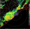
Severe Thunderstorm Watch
SEVERE THUNDERSTORM WATCH 349 REMAINS VALID UNTIL 11 PM EDT THIS EVENING FOR THE FOLLOWING AREAS IN NORTH CAROLINA THIS WATCH INCLUDES 6 COUNTIES IN SOUTHEAST NORTH CAROLINA BLADEN BRUNSWICK COLUMBUS NEW HANOVER PENDER ROBESON IN SOUTH CAROLINA THIS WATCH INCLUDES 8 COUNTIES IN NORTHEAST SOUTH CAROLINA DARLINGTON DILLON FLORENCE GEORGETOWN HORRY MARION MARLBORO WILLIAMSBURG THIS INCLUDES THE CITIES OF ANDREWS, BENNETTSVILLE, BLADENBORO, BOILING SPRING LAKES, BURGAW, CHADBOURN, CONWAY, DARLINGTON, DILLON, ELIZABETHTOWN, FLORENCE, GARDEN CITY, GEORGETOWN, HARTSVILLE, KINGSTREE, LAKE WACCAMAW, LELAND, LITTLE RIVER, LONG BEACH, LUMBERTON, MARION, MCCOLL, MULLINS, MURRELLS INLET, MYRTLE BEACH, NORTH HARTSVILLE, NORTH MYRTLE BEACH, OAK ISLAND, RED HILL, SOCASTEE, SOUTHPORT, SUNSET BEACH, SURF CITY, TABOR CITY, WHITEVILLE, AND WILMINGTON.
- Bladen, NC
- Brunswick, NC
- Columbus, NC
- New Hanover, NC
- Pender, NC


Looks like it kinda started to die after crossing the AL/GA line to me which is weird because its so hot and humid outsideIs it me or do severe thunderstorm warnings never seem to bear out anymore in North GA? This “severe” storm had hardly any lightning with it and no where near 70mph winds.
Thunder has been rumbling steadily here for a half hour, but it's taking forever for something to get here.
I'll be surprised if it doesn't happen, it's just kinda funny.

 www.facebook.com


Possible derecho tonight. Also the Thunder Pacers play in the NBA finals tonight in OKC. Gonna be a close callView attachment 173031