• Hello, please take a minute to check out our awesome content, contributed by the wonderful members of our community. We hope you'll add your own thoughts and opinions by making a free account!

Severe 2025 Severe Thread

Severe thunderstorms in Cobb County moving SE from Sweat Mtn. Batten down Marietta area!

BULLETIN - IMMEDIATE BROADCAST REQUESTED
SEVERE THUNDERSTORM WARNING
NATIONAL WEATHER SERVICE PEACHTREE CITY GA
829 PM EDT SUN MAY 25 2025

THE NATIONAL WEATHER SERVICE IN PEACHTREE CITY HAS ISSUED A

* SEVERE THUNDERSTORM WARNING FOR...
NORTHWESTERN DEKALB COUNTY IN NORTH CENTRAL GEORGIA...
NORTHEASTERN COBB COUNTY IN NORTH CENTRAL GEORGIA... WEST
CENTRAL GWINNETT COUNTY IN NORTH CENTRAL GEORGIA...
NORTHEASTERN FULTON COUNTY IN NORTH CENTRAL GEORGIA...

* UNTIL 915 PM EDT.

* AT 829 PM EDT, A SEVERE THUNDERSTORM WAS LOCATED OVER SWEAT
MOUNTAIN, OR NEAR MOUNTAIN PARK, MOVING SOUTHEAST AT 35 MPH.

HAZARD...60 MPH WIND GUSTS AND QUARTER SIZE HAIL.

SOURCE...RADAR INDICATED.

IMPACT...HAIL DAMAGE TO VEHICLES IS EXPECTED. EXPECT WIND
DAMAGE TO ROOFS, SIDING, AND TREES.

* LOCATIONS IMPACTED INCLUDE...
ATLANTA, MARIETTA, PEACHTREE CORNERS, MOUNTAIN PARK, SANDY
SPRINGS, ROSWELL, JOHNS CREEK, ALPHARETTA, DUNWOODY, DULUTH,
CHAMBLEE, NORCROSS, DORAVILLE, BERKELEY LAKE, NORTH ATLANTA,
TUCKER, MOUNT BETHEL, SWEAT MOUNTAIN, MECHANICSVILLE, AND SANDY
PLAINS.
 
Gotta watch for a elevated tornado threat during the next few hours from Tuscaloosa toward the east; south of Birmingham. Looks like a bookend vortex is about to spin up.
 
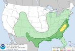
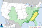
Day 3 Convective Outlook
NWS Storm Prediction Center Norman OK
0226 PM CDT Wed May 28 2025

Valid 301200Z - 311200Z

...THERE IS A SLIGHT RISK OF SEVERE THUNDERSTORMS FOR PARTS OF THE
SOUTHEAST AND SOUTHERN MID-ATLANTIC...

...SUMMARY...
Scattered severe storms with wind damage, large hail, and a few
tornadoes will be possible Friday afternoon through late Friday
evening across parts of the Mid-Atlantic and Southeast.

...Mid-Atlantic and Southeast...
Pattern amplification will occur Friday as one shortwave trough
progresses from the Mid-South to the southeast Atlantic/Mid-Atlantic
coast, in advance of another wave digging southward over the Great
Lakes. An associated surface cyclone will develop
east-northeastward across the Mid-Atlantic late Friday and to the
southern New England coast by Saturday morning, while a trailing
cold front crosses the Gulf coast, north FL and the southeast
Atlantic coast. Within cloud breaks the warm sector will consist of
afternoon temperatures near or above 80 F and boundary-layer
dewpoints in the 60s, which will drive MLCAPE of 1000-2000+ J/kg and
minimal convective inhibition by early-mid afternoon. Increasing
midlevel flow with time and forcing for ascent along and just ahead
of the front will support storm initiation with the potential for
storm clusters and some supercells capable of producing damaging
winds, large hail and a few tornadoes. If wave timing and
thermodynamic profiles remain favorable, some portion of this area
may warrant an upgrade in later updates.


..Thompson.. 05/28/2025

Things getting a little more serious for Friday with a bigger slight risk and a possible upgrade coming.
 
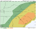
Severe threats behind departing shortwaves are always a pain. Remove the overnight shortwave from this setup and tomorrow is a straight forward event. I think the overnight wave makes it messy and introduces the potential for lingering stratus, mixing dews, too much subsidence. I wouldn't be shocked though to see tomorrow upgraded between US1 and I85 or so though given the higher end wind potential and the non zero tornado potential before things get fully linear
 
I heard it was DVD sized too!
To add on
033
WFUS54 KLUB 252214
TORLUB
TXC101-125-269-345-252245-
/O.NEW.KLUB.TO.W.0027.250525T2214Z-250525T2245Z/

BULLETIN - EAS ACTIVATION REQUESTED
Tornado Warning
National Weather Service Lubbock TX
514 PM CDT Sun May 25 2025

The National Weather Service in Lubbock Texas has issued a

* Tornado Warning for...
Northeastern Dickens County in northwestern Texas...
Northwestern King County in northwestern Texas...
Southeastern Motley County in northwestern Texas...
Southwestern Cottle County in northwestern Texas...

* Until 545 PM CDT.

* At 514 PM CDT, a severe thunderstorm capable of producing a tornado
was located 5 miles southwest of Dumont, or 17 miles northeast of
Dickens, moving east at 20 mph.

HAZARD...Tornado and DVD size hail.

SOURCE...Radar indicated rotation. DVD size hail was also reported
2 miles northwest of Afton.

IMPACT...Flying debris will be dangerous to those caught without
shelter. Mobile homes will be damaged or destroyed.
Damage to roofs, windows, and vehicles will occur. Tree
damage is likely.

* This dangerous storm will be near...
Dumont around 520 PM CDT.

PRECAUTIONARY/PREPAREDNESS ACTIONS...

TAKE COVER NOW! Move to a basement or an interior room on the lowest
floor of a sturdy building. Avoid windows. If you are outdoors, in a
mobile home, or in a vehicle, move to the closest substantial shelter
and protect yourself from flying debris.

Heavy rainfall may hide this tornado. Do not wait to see or hear the
tornado. TAKE COVER NOW!

Torrential rainfall is occurring with this storm, and may lead to
flash flooding. Do not drive your vehicle through flooded roadways.

&&

LAT...LON 3367 10067 3386 10070 3391 10036 3364 10038
TIME...MOT...LOC 2214Z 264DEG 17KT 3376 10059

TORNADO...RADAR INDICATED
MAX HAIL SIZE...5.00 IN

$$

SINCAVAGE
It was indeed DVD sized!!!
 
And for SC/GA/NC
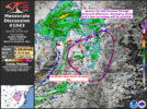
Mesoscale Discussion 1036
NWS Storm Prediction Center Norman OK
1147 AM CDT Thu May 29 2025

Areas affected...Portions of southeastern Georgia and eastern South
Carolina

Concerning...Severe potential...Watch likely

Valid 291647Z - 291815Z

Probability of Watch Issuance...80 percent

SUMMARY...Storm coverage expected to increase over the next few
hours, posing a threat for damaging wind gusts and some severe hail.
Watch issuance is expected by early to mid afternoon.

DISCUSSION...Regional radar shows a broad area of stratiform rain
with a few more intense cells embedded, advancing northeastward
across portions of central Georgia. Ahead of this activity, morning
clearing has allowed for rapid destabilization, yielding 1500-2000
J/kg of MLCAPE across southeast Georgia and eastern South Carolina.
The lack of appreciable CIN is leading to a steady increase in new
storm development across the region, in addition to the
aforementioned ongoing activity. Effective bulk shear of 30-35 kt
should promote a few loosely organized clusters with time, with
damaging wind gusts being the primary threat. Severe hail is also
possible, particularly with any isolated cells early on. Given the
widespread storm coverage anticipated and severe storm potential, a
watch will likely be needed by early to mid afternoon.

..Karstens/Smith.. 05/29/2025

...Please see www.spc.noaa.gov for graphic product...

ATTN...WFO...ILM...CHS...CAE...JAX...FFC...TAE...

LAT...LON 30608147 30748295 31328362 33068248 33808089 33447906
32617955 31538108 30608147

MOST PROBABLE PEAK TORNADO INTENSITY...UP TO 95 MPH
MOST PROBABLE PEAK WIND GUST...55-70 MPH
MOST PROBABLE PEAK HAIL SIZE...UP TO 1.25 IN
 
FLASH FLOOD WARNING FOR @SD AND
WGUS52 KRAH 292138
FFWRAH
NCC051-085-101-163-300045-
/O.NEW.KRAH.FF.W.0006.250529T2138Z-250530T0045Z/
/00000.0.ER.000000T0000Z.000000T0000Z.000000T0000Z.OO/

BULLETIN - EAS ACTIVATION REQUESTED
Flash Flood Warning
National Weather Service Raleigh NC
538 PM EDT Thu May 29 2025

The National Weather Service in Raleigh has issued a

* Flash Flood Warning for...
Northern Cumberland County in central North Carolina...
Southeastern Harnett County in central North Carolina...
Southwestern Johnston County in central North Carolina...
Northwestern Sampson County in central North Carolina...

* Until 845 PM EDT.

* At 538 PM EDT, Doppler radar indicated thunderstorms producing
heavy rain across the warned area. Up to 2.5 inches of rain have
fallen. Additional rainfall amounts up to 1 inch are possible in
the warned area. Flash flooding is ongoing or expected to begin
shortly.

HAZARD...Flash flooding caused by thunderstorms.

SOURCE...Radar.

IMPACT...Flash flooding of small creeks and streams, urban
areas, highways, streets and underpasses as well as
other poor drainage and low-lying areas.

* Some locations that will experience flash flooding include...
Fayetteville, Fort Bragg, Dunn, Benson, Godwin, Pope AFB, Spring
Lake, Erwin, Eastover, Newton Grove, Wade, Falcon, Linden, Vander,
Spivey's Corner, Anderson Creek, Timberlake and Bonnie Doone.

PRECAUTIONARY/PREPAREDNESS ACTIONS...

Turn around, don't drown when encountering flooded roads. Most flood
deaths occur in vehicles.

Be aware of your surroundings and do not drive on flooded roads.

&&

LAT...LON 3536 7876 3541 7848 3530 7832 3519 7835
3512 7849 3507 7861 3500 7896 3505 7909
3506 7909 3507 7909 3510 7910 3516 7910
3518 7910 3528 7900

FLASH FLOOD...RADAR INDICATED

$$

CA
 
Looks like it could be a very active day around here. Hope people are paying attention. I know WRAL has been getting grief about all their weather alert days lately, but this looks legit.
 
It's very overcast here still. Haven't seen the sun at all yet. Maybe if it stays that way it will cut down the instability for this afternoon and evening.
 
It's very overcast here still. Haven't seen the sun at all yet. Maybe if it stays that way it will cut down the instability for this afternoon and evening.
obviously instability helps but i think the main driver for this event is healthy forcing ahead of trough. this is a little more dynamic than what we typically see in late may
 
  • Like
Reactions: SD
Back
Top