-
Hello, please take a minute to check out our awesome content, contributed by the wonderful members of our community. We hope you'll add your own thoughts and opinions by making a free account!
You are using an out of date browser. It may not display this or other websites correctly.
You should upgrade or use an alternative browser.
You should upgrade or use an alternative browser.
Tropical 2022 Atlantic Hurricane Season thread
- Thread starter Snowfan
- Start date
Brent
Member
This thread ought to be lively in a few months
Tropical weather outlooks start on May 15th now! It'll be here before you know it
Tropical weather outlooks start on May 15th now! It'll be here before you know it
Brent
Member

Shary and Virginie?
pcbjr
Member
I for one and praying not ...This thread ought to be lively in a few months
Tropical weather outlooks start on May 15th now! It'll be here before you know it
Our Father who art in heaven ...
Hail Mary, full of grace ...
St. Jude, patron of lost causes and hopeless cases ...
La Niña will be fading. This tropical season will be even storms than last years season, IMO
lexxnchloe
Member
The high heights over NE Canada were supposed to cause a big east coast season last year but instead we ended up with a trof and recurves. I guess we will have to wait and see.
Downeastnc
Member
Crazy
Crazy
Fell for it hook line and sinker.
Downeastnc
Member
Fell for it hook line and sinker.
LOL when I first read it I was like is there anything Elon Musk cant do...then I was like why it gotta be Saharan dust....
accu35
Member
Wont be long for the LR gfs to start showing these early month of May storms.
Brent
Member
Wont be long for the LR gfs to start showing these early month of May storms.
Can't wait for the first lopsided naked swirl that may or may not have a closed center to get things going
Downeastnc
Member
Tornadocane
Member
Tornadocane
Member
Here it comes!
HSVweather
Member
HSVweather
Member
Brent
Member
Fantasy land but the long range GFS shows something trying to form in the Caribbean. Whether this is real or not it's definitely not gonna be long before we start seeing noise at least

HSVweather
Member
HSVweather
Member
Brent
Member
Ida retired and replaced by Imani in 2027
I'll withhold my thoughts on why this is the case.....it's not popular around these parts.
Detective WX
Member
Not to open a can of worms here, but we running out of "I" names... Soon, there won't be any "I" names at all at this clip.Ida retired and replaced by Imani in 2027
Brent
Member
Not to open a can of worms here, but we running out of "I" names... Soon, there won't be any "I" names at all at this clip.
Oh no argument there. It's getting so bad there's been talk in other places about getting rid of I names
Even when we went Greek in 2020 the I name got retired!
brendan123
Member
Will be in Miami for college starting in August, could get interesting depending on how this season turns out. Hasn't been a storm down there since Irma though, hoping that trend continues.
Brent
Member
GFS trying to show something again in the super long range
HSVweather
Member
Brent
Member
Yeah I'm starting to get a little intrigued. Something weak could definitely pop with the Gulf stream on that track
Alex is the first name
Brent
Member
GFS still showing a chance at Alex end of next week

Downeastnc
Member
HSVweather
Member
06z GFS

HSVweather
Member
12Z GFS still has something but develops it later and much further south, of course this is all voodoo/lala land lol

HSVweather
Member
18Z GFS

That's a weird track.
HSVweather
Member
Yeah, long range GFS being weird. It was still there GFS 0Z so the signal is consistent, for nowThat's a weird track.
HSVweather
Member
0Z GFS

HSVweather
Member
6Z has it much weaker and forming around Cuba before fading away in the GoM
HSVweather
Member
LOL, 12Z GFS gone mad

Tornadocane
Member
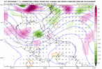
I've been watching the tropical wave during this time frame for the last several days due to the rain potential, and the GFS has slowly trended towards this North Caribbean Wave/Central American Gyre dance that consolidates in the Caribbean instead of the East Pacific. The climate always favors the East PAC this time of year, but I think the GFS has been sensing better dynamics and upper level environment in the Western Caribbean. The 200-400Mb Q-Div, Stream Function Map illustrates a much better convective pattern over the Caribbean for tropical cyclone consolidation, and that area just so happens to be an area with rapidly warming SSTs that will be just to the SE of what remains of in the Gulf from our cut-off low that moves out over the next couple days. It creates one of those mini-troughs under a high pressure in the Gulf that keeps lower pressures in the Western Caribbean.
Needless to say, the May 19-24 period has my attention.
Look at the GIF from 84-150 Hours. You see the trough in the Gulf become the catalyst for convection and lower pressures in the West Caribbean with the convergence zone setting between it and the Upper Level Ridge, and then you see the excellent divergence at the end when the Ridge moves into the area. Later on another shortwave trough forms in the Gulf, and we get one of the early-season hybrid cyclone with a lopsided rain-shield. You can see the upper level energy digging under the system. On the Relative Humidity Map, the upper level energy is also accompanied by dry air that wraps around the system.
Attachments
Last edited: