Webberweather53
Meteorologist
3rd ban? Yea for you3rd ban is a miller a storm around Christmas btw.still on the table
3rd ban? Yea for you3rd ban is a miller a storm around Christmas btw.still on the table
This is the Whamby thread, where we punt whole months of winter before they even begin!Punt December? Do you expect the SER to become predominant next week?

Awful winters always verifyCFS looks pretty awful all winter, though they always do every winter, so meh.
What the ----?And yes i typed in about 4 f bombs
Look at the bright side. At least we're not getting taken in and suckered by head poops this year.Fantasy storms sure have been lame. I haven’t seen my 2ft snowstorm with 3in of ice yet.
That was really disappointing. I knew it would happen though. Always seems to.poop the panthers I’m pissed off right now, didn’t go for it on a pooping 4th and 1, poop this poverty organization we pooping choked
0 line down near Phil ain't too shabbyFantasy storms sure have been lame. I haven’t seen my 2ft snowstorm with 3in of ice yet.
There will be snow in Cuba before long.Phil snow 3 man rush ------- blows, he’s a ---- play caller, Phil snow is the only snow I don’t like !Made Kirk cousins look good
That is crazy... coldest low for Portland, ME this week 33, Pensacola, 31.Hard to believe that it's not even forecast to get down to 32 in Portland, ME this week. Meanwhile the FL panhandle could get as cold as 24 !
I have packed my bags as a Carolina fan and I’m officially becoming a Steelers fan !! At least they have a quarterback who can throw over 40 yards and have a defense that can make stops, and don’t over pay a RB who’s injured all season, I will officially become a Steelers fan
Actually you can ! You can change football teams and you can move to a place with different weather !Funny the two things I complain about the most, weather and football, I can't do a pooping thing about!
Fire Phil Snow!poop the panthers I’m pissed off right now, didn’t go for it on a pooping 4th and 1, poop this poverty organization we pooping choked
Maybe one day I'll live in a snowy climate when I don't have to work anymore or even leave the house unless I want to.Actually you can ! You can change football teams and you can move to a place with different weather !

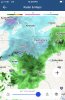
Definitely a winter type storm.Dry slotted... rain storm cancel!View attachment 54535

3 looks fun. 14 as well.GEFS looking pretty good in 15 days!View attachment 54536
4 too !3 looks fun. 14 as well.
I’d take anything.4 too !
That's going to be right towards Braselton and be right over @NoSnowATLDry slotted... rain storm cancel!View attachment 54535
Missed me to the west. Just light rain so far tonight.That's going to be right towards Braselton and be right over @NoSnowATL
GEFS looking pretty good in 15 days!
Tropical.Does anyone know what the weather is like in the outer banks in early March? Going there for a vacation March 7th. Would be awesome to see a blizzard lol
Sent from my Pixel 3 using Tapatalk

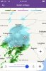
Can I get a date?Did Upstate SC get much from this?
View attachment 54555
Oh sorry... Feb 8 2020.Can I get a date?
Dusting IMBY, but western areas got a surprise thump. @Webberweather53 thx for the mapOh sorry... Feb 8 2020.