-
Hello, please take a minute to check out our awesome content, contributed by the wonderful members of our community. We hope you'll add your own thoughts and opinions by making a free account!
You are using an out of date browser. It may not display this or other websites correctly.
You should upgrade or use an alternative browser.
You should upgrade or use an alternative browser.
Wintry 1/9-12 Winter Potential Great Dane or Yorkie
- Thread starter SD
- Start date

Bigedd09
Member
RGEM very similar to 12z
Blue_Ridge_Escarpment
Member
Biggest difference I’m seeing at 18Z runs today is the more neutral tilt vs the 6Z and 12Z runs
- Joined
- Jan 23, 2021
- Messages
- 4,603
- Reaction score
- 15,199
- Location
- Lebanon Township, Durham County NC
My last three ICON runs:
18z - 8”
12z - 6”
6z - 7”

18z - 8”
12z - 6”
6z - 7”
RGEM has been consistently doing this for quite a few runs now out west. This isn't just a blip. It also isn't really a surprise.

18z RDPS

Stormsfury
Member
One thing of note...can clearly see the isoballic kink offshore of SC/GA... The wedge is stout and extends well offshore..
Makeitsnow
Member
Hard to take the icon very seriously when it seems so far off with surface temps. It's a good 10 degrees warmer with dewpoints vs every other piece of guidance. If one is to believe the icon temps at the surface only cool 2 to 3 degrees after saturation which seems absurd. If it's this off at the surface I would urge caution overall.that's lights out for southern upstate with our 1.4 inch snow in the Clinton area.
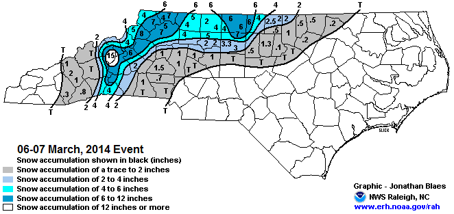
Good point, James. A cold air mass can hang on longer than we sometimes expect. Makes this hobby fun. This one is pretty shallow, and heavier rates may overwhelm it more efficiently.The March 2014 ice storm did exactly that, IIRC (might've not been a half inch, but I believe it was at least a quarter and caused widespread power outages in GSO). Also ended up with a lot of sleet. Oddly, that was also a Miller A with in situ CAD that didn’t fully wear off until the end of the storm (and it was in the 60s a day or two later, which was nice considering the ice storm knocked out power for several days IMBY). We got a ton of IP, then to ZR and finally -RN at the end as temps climbed from 29ish to slightly above freezing by the end. It also wasn’t really forecasted until go time and warnings didn’t go out until after precip began, IIRC. Not sure if it’s much of a true analog to this one, but we can get ice storms from unusual situations like this.
Of course, that’s a setup that works better for the Triad than Triangle, but it is January rather than March now. In situ CAD usually lasts longer at the surface than forecasted, IMO.
Wasn’t February 2014 in situ CAD, too? (Of course, that’s did change to rain for the Triangle whereas the Triad mixed to sleet and ZR after 6” of snow.)
All in all, the some of the 12Zs and the 18Zs so far have halted the trends of the colder and snowier solutions for the southern fringes. I was hoping we had another 24 hours of good trends to get through before going north.
Short range guidance like the NAM and the RGEM are locked in to colder scenarios & ice storms.

would guidance from the RGEM be compromised due to the lower third of the baja low being outside of its domain?RGEM has been consistently doing this for quite a few runs now out west. This isn't just a blip. It also isn't really a surprise.
View attachment 160957
NWS Peactree City/Atlanta Afternoon Disco
.LONG TERM...
(Thursday morning through next Monday)
Issued at 356 PM EST Tue Jan 7 2025
Key Messages:
- Primary impact through the long term will be winter weather on
Friday into Friday night. Greatest probability of impactful wx
will be in northern Georgia through metro Atlanta. Areas south
of I-20 are more uncertain, as southward extent of frozen precip
is uncertain at this time.
- Snow looks to be primary precip time in northern Georgia and the
mountains as of this forecast package. Some uncertainty in
amounts, but probability of at least 1" across the models is
greater than 80% in many locations.
- More uncertainty into the metro. Precip type is likely to be
frozen, but what exactly is still uncertain. Snow, sleet, and
freezing rain potential are all still on the table.
- South of I-20, uncertain if we can remain below freezing during
the day on Friday. Current forecast would see a transition to
rain that would likely occur before any meaningful accumulation
of snow or other icy precip could occur.
Forecast:
Models are honing in on what would be an impactful winter weather
event across much of northern Georgia, including metro Atlanta, on
Friday. To start with the synoptic setup - cold air mass continues
to linger in the area during the day on Thursday. Model data
assimilation is now able to better initialize with any potential
snow pack in place after significant winter event that passed across
KY/TN, which is likely having some impact on surface temperatures.
We will see another wave pass by the area on Thursday aloft that
will be dry, but will push a reinforcing shot of cold air in on
Thursday into Thursday night. This will set the stage for winter
precipitation on Friday, allowing our surface air mass to be cold
enough for some sort of frozen precip. Two significant upper level
features, a cut off low over the desert southwest, and another
shortwave quickly moving within the polar jet, will phase together
and eject into the southeast on Friday into Saturday. Wave will
interact with significant baroclinicity in place across the Gulf
coast with cold air settled in place and generate strong surface low
within region of PVA ahead of it. This will bring precip and the
potential for winter weather across wide swath of the south,
including our CWA.
Confidence at this point is high across northern Georgia in seeing
snow as the primary precipitation type. Cold airmass looks to be
locked in place, and profiles aloft show plenty of moisture, lift
through the DGZ, and all points below 0 C. At this time the question
may be where the exact track of the low is, which will have impacts
on just how much snow falls in this area. Chances seem good that we
may see a decent band of snowfall set up over the northern portion
of the state which could lead to snow totals of several inches.
Important to note here that 10:1 maps in the models are likely to be
overestimating snowfall - soundings show near isothermal layer just
above freezing that extends well aloft, so snow that falls is likely
to be classic southern snow - wet and heavy, bringing ratios down to
8 or 7:1 (and maybe lower, depending). Keep this in mind.
Into the metro and along I-85, including Athens, things get a lot
more uncertain. A bit of an "in-situ" wedge may be able to set up,
with cold air in place being pushed up against the Appalachians as
the low passes to the south. This creates a little uncertainty in
the models as to surface temperatures. Current forecast expectation
is these should stay at or below freezing, especially as precip is
ongoing, which should keep p-types frozen. The other piece of
uncertainty is something models struggle with in any southern winter
system, which is the strength of the warm nose within the WCB.
Models uniformly tend to underestimate this. This would likely lead
to a more mixed precip type, with freezing rain or sleet, rather
than some of the more aggressive snow solutions that models have
advertised in the 12Z output. This forecast package will continue to
maintain some freezing rain with snow chances across this area. As
we get closer in time and get access to some hi-res info, expect
this to be refined.
Points further south are more uncertain with regard to maintaining
the cold air at the surface. Where locations can stay below freezing
during the day on Friday is uncertain, which will obvious impact the
southern extent of impactful winter weather. Model probabilities
have pushed higher a bit further south, likely representative of
more southerly solutions within the forecast low track that help
keep cooler air in place. Precip type is likely to frozen at onset
during the morning hours in most areas south of I-20, but the
expectation for now is that this would transition to mix or all rain
during the afternoon. This would likely severely limit any
accumulations or impacts, as the heaviest precip would likely be
all liquid.
System begins to clear the area by Saturday morning. Cold air will
settle back in. Some uncertainty on high temperatures, especially
across northern Georgia, as snowfall accumulation is likely to have
impacts models may not fully realize. Have chosen to mix in a little
bit of the NBM 10th percentile in these areas to bump highs down.
Either way, many areas that could see impactful accumulations of
snow or ice will likely see only a few hours at most above freezing,
meaning untreated or unplowed roadways are likely to see refreeze
Saturday night as temperatures drop well into the teens and 20s.
Cold air lingers through the weekend and into early next week, with
highs in the upper 30s to lower 40s in north Georgia and mid to
upper 50s and a few 50s in central Georgia.
It also tracks the sfc low through the middle of GA..oopShort range guidance like the NAM and the RGEM are locked in to colder scenarios & ice storms.
View attachment 160960
Now that looks more realistic the southern facing apps always benefits from storms like this with Lift.Woof. ICON is way north for the I20 gang View attachment 160952
iGRXY
Member
I would ask everyone to please step back from the ledge and wait until we get in the HRRR, 3K, and CAMs get into range. This was step for step exactly what happened in 2022. Let's see what the FGEN thump looks like as we get closer and see how long it takes for a change over to take place.
This Track is a gut kicker. My bench mark is always Pensacola to Savannah. Safest bet. You stay on or right of that line, you'll stay all snow here in the Triad 99x out of 100.
You waffle a half step left ( NW side) and your asking for mixing issues. You see RGEM in central GA and like GFS prior runs, I can litterally reach out my front door and touch the transition line on these clowns. The track, trajectory / most importantly is the deal setter once at Pensacola.
You waffle a half step left ( NW side) and your asking for mixing issues. You see RGEM in central GA and like GFS prior runs, I can litterally reach out my front door and touch the transition line on these clowns. The track, trajectory / most importantly is the deal setter once at Pensacola.
- Joined
- Jan 23, 2021
- Messages
- 4,603
- Reaction score
- 15,199
- Location
- Lebanon Township, Durham County NC
There’s a lot of trees that got loosened up from Augusta to Greenwood and north in September.
As someone who lived through 2002 ice storm that followed Hugo in 1989, that depiction(even half of it) would cause tremendous damage in SC and GA.
As someone who lived through 2002 ice storm that followed Hugo in 1989, that depiction(even half of it) would cause tremendous damage in SC and GA.
beanskip
Member
Interestingly, surface temps for the 18z ICON were actually lower over N.C./S.C. update vs. the snowy 12z run. Obviously snow was hijacked by mixing.
I WISH I was where you are for NC winter weather. Try being in Cabarrus County. I literally want to rip 85 out of the ground!! It’s a curse. lol Enjoy!This Track is a gut kicker. My bench mark is always Pensacola to Savannah. Safest bet. You stay on or right of that line, you'll stay all snow here in the Triad 99x out of 100.
You waffle a half step left ( NW side) and your asking for mixing issues. You see RGEM in central GA and like GFS prior runs, I can litterally reach out my front door and touch the transition line on these clowns. The track, trajectory / most importantly is the deal setter once at Pensacola.
ChattaVOL
Member
- Joined
- Jan 23, 2021
- Messages
- 4,603
- Reaction score
- 15,199
- Location
- Lebanon Township, Durham County NC

18z ICON extracted data
The bottom line is that a lot of us look to get a notable winter storm out of this. Whether it’s predominantly snow or not remains an open question, but a lot of us will get something, and something is better than nothing. And nothing is all we’ve gotten for the last few years.
There is a baked assumption that things always trend worse leading up to an event, but I really think if you looked at solid data on that, it probably wouldn’t actually be true. What mechanism would cause that? I think we sometimes get that impression because we depend too much on overdone clown maps and human psychology makes us remember things trending towards the worse rather than towards the better.
There is a baked assumption that things always trend worse leading up to an event, but I really think if you looked at solid data on that, it probably wouldn’t actually be true. What mechanism would cause that? I think we sometimes get that impression because we depend too much on overdone clown maps and human psychology makes us remember things trending towards the worse rather than towards the better.
Big fan of the GRAF. It done well the other day in NC. And it done fantastic during Hurricane Helene.
Triplephase93
Member
Local TV here in Chattanooga calling for 4-8 inches….
A little surprised….
Gutsy call. Starting to worry about mixing issues and wasting QPF slightly above freezing.
Bigedd09
Member
Big fan of the GRAF. It done well the other day in NC. And it done fantastic during Hurricane Helene.
Not a fan of that freezing line just shooting north like that
- Joined
- Jan 23, 2021
- Messages
- 4,603
- Reaction score
- 15,199
- Location
- Lebanon Township, Durham County NC
Evaporative cooling will handle thatNot a fan of that freezing line just shooting north like that
Would assume it is fed boundary conditions from the op CMC?would guidance from the RGEM be compromised due to the lower third of the baja low being outside of its domain?
baja low still trending a touch west at hour 30 on 18z gfs. hoping it leads to that southernmost portion of the vort getting squashed so the rest of the trough can flourish
albertwilsonjr
Member
These models are underestimating the cold
This video is probably close to what is gonna happen
Sent from my iPhone using Tapatalk
- Joined
- Jan 23, 2021
- Messages
- 4,603
- Reaction score
- 15,199
- Location
- Lebanon Township, Durham County NC
Weather channel just had the lead forecaster from DFW which is certainly interesting
HixsonWX
Member
They've upped it. This morning, their forecast was for 2"-5".Gutsy call. Starting to worry about mixing issues and wasting QPF slightly above freezing.

beanskip
Member
18z GFS about 1-3 degrees colder at surface for virtually entire southeast vs. this time yesterday, at 48 hours. Freezing line has also pressed south quite a bit.
iGRXY
Member
Dropping the N/S energy out of Canada down faster as wellbaja low still trending a touch west at hour 30 on 18z gfs. hoping it leads to that southernmost portion of the vort getting squashed so the rest of the trough can flourish
albertwilsonjr
Member
Log into Facebook
Log into Facebook to start sharing and connecting with your friends, family, and people you know.
 www.facebook.com
Chris Justus first snow totals
Sent from my iPhone using Tapatalk
The GFS is here to save the Birmingham/Atlanta weenies 

all the little things i'm watching (cold press, baja low position, tilt in the desert) look slightly better this run at 54, excited to see where this leads
JLL1973
Member
gfs is going to be a banger for the midsouth area