Snowlover34
Member
The way the models been going up here in the Tennessee valley they might as well down grade the winter storm warning we might just be getting a cold rain with the warm nose consistently pushing north
I think they'll be in line with Alabama's offices with a sharp curve north. Usually offices follow officesFascinated to see how far south FFC goes with the Winter Storm Warning here in a bit in Georgia. You could argue they don’t even need to go down to I-20 anymore
I’m not sure why they wouldn’t include sleet in their snowfall maps. The NWS counts sleet officially as snowfall. You’re right though. It looks to me like once again, soundings aren’t being looked at closely. A lot of what these models are depicting as ZR is occurring with 925mb temperatures below freezing, so that should be sleet. We saw the same thing in January 2022Pretty absurd that NWS GSP has "1 inch" total for the I-85 corridor. Worst case scenario, we're getting 2+ inches of sleet.
Or maybe they don't add sleet totals to their snowfall map? Which would be idiotic since the public would be affected the same way.
I think that's a stretch. Given the expected model error in surface temps (probably at least 3 degrees) freezing rain is going to be a pretty big issue down that way.Fascinated to see how far south FFC goes with the Winter Storm Warning here in a bit in Georgia. You could argue they don’t even need to go down to I-20 anymore
Fascinated to see how far south FFC goes with the Winter Storm Warning here in a bit in Georgia. You could argue they don’t even need to go down to I-20 anymore
Or maybe it will be more sleet for I-20 ?I think that's a stretch. Given the expected model error in surface temps (probably at least 3 degrees) freezing rain is going to be a pretty big issue down that way.
How much is being reported on the ground though? Want to rule virga out.The precip shield on radar looks to be out performing the HRRR..
Consolation prize WWA seems inevitable, but hard to say with sleet and freezing rain maybe still causing some headaches at first.Fascinated to see how far south FFC goes with the Winter Storm Warning here in a bit in Georgia. You could argue they don’t even need to go down to I-20 anymore
If true, are we sure that’s a good thing lol? Could mean more amped/warmer and we can’t afford thatThe precip shield on radar looks to be out performing the HRRR..
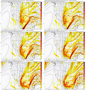
No? Look at the 700 and 850 layers. It's a tick south/colder.RGEM coming further north as well. Never underestimate the NAM and its ability to detect the warm nose.
mPING’s look like it is falling.. all the way near the New Mexico and Mexico line and north of OKC.How much is being reported on the ground though? Want to rule virga out.

That’s important to remember. I’m not sure what FFC’s warning criteria is for sleet, but I know that GSP’s is .5”. With ground temperatures as cold as they are, .5” of sleet will absolutely have the impact of a major winter stormOr maybe it will be more sleet for I-20 ?
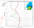
The (Not very reliable) WRF Suite has less warm nose in AL, GA and Southern TN too. NAM is torching just below 700MBs compared everything else. I'd love for the NAM to be wrong but it's usually pretty good with warm nose issues.I would not love being a Met at MRX today. Where I'm at (1800' feet up just northwest of Chattanooga) - I've got Globals showing mostly snow and the Meso's showing:
HRRR - 6" snow and half inch of sleet
Fv3 - 9 inches of snow - all snow
NAM - Disaster - Trace to inch of snow and sleet storm of 2+ inches.
My question for you guys is this: At this range, which models do you put the most stock in on the ~700MB warm nose?
I just know when storms have out performed out west it usually bodes well for us..If true, are we sure that’s a good thing lol? Could mean more amped/warmer and we can’t afford that
Apps runner, phase, amp 3 phrases that need reevaluation after this system bc they are getting really misused/interpretedi keep on seeing “Apps Runner” thrown around, but has any model actually shown that? Seems like there’s been some Miller B-type systems, but I thought even the worst HRRR runs would’ve transferred to a secondary low off the coast eventually (granted, perhaps too late for any of us to benefit)?

Pivotal must be off, cause it had several hours of sleet from charlotte to huntersville
Actually it’s a tick south. As for the NAM and detecting a warm nose, I don’t think anyone can ever honestly dismiss that with it. I know I can’t because I’ve been on the wrong side of too many busted forecasts the last 10 years. What I will say and what I was saying last night was that I didn’t see how anyone could seriously take the low track it was giving at 0z seriously when it was nothing like anything we had seen on any modeling previously. The fact that it shifted the low track to almost the Gulf Coast at 12z from cutting up into Tennessee on the 0z is pretty good proofRGEM coming further north as well. Never underestimate the NAM and its ability to detect the warm nose.
Can you show it?FV3 is dramatically colder and south. Almost all snow on the N metro ATL region
What i'm thinking for the tidewater:ahhh come on lol let's hear it!
Geez.. RGEM locked and now this.. I definitely don’t want to be a forecaster at FFC..FV3 is dramatically colder and south. Almost all snow on the N metro ATL region
