- Joined
- Jan 23, 2021
- Messages
- 4,602
- Reaction score
- 15,197
- Location
- Lebanon Township, Durham County NC
it's actually held serve or is slightly colder hereEuro and ukie both a tick warmer at sfc? That gets a quiet ruh roh from me
it's actually held serve or is slightly colder hereEuro and ukie both a tick warmer at sfc? That gets a quiet ruh roh from me
I have no idea what to believe I guess I need to look for myself instead of reading this board. How’s it actually look thenit's actually colder here
Weather Channel taking a blend of gfs and euro.
Yeah, the 12z EURO looks drier in the Carolinas this round.EPS was almost double the QPF of the euro last run.
It isnt a whole lot but just around -1I have no idea what to believe I guess I need to look for myself instead of reading this board. How’s it actually look then
Got a run2run 2m difference gif?It isnt a whole lot but just around -1
Sfc held serve but the warm nose is back. Rdu flips to zrI have no idea what to believe I guess I need to look for myself instead of reading this board. How’s it actually look then

That is way more snowy members for nc over icey
Thats Really not an unrealistic Looking Map.... I-85 N/W 2-4" Pockets of 5" And some ICE on top GA-SC-NC
Yeah, temps look okay with it to my initial eye, we just have to hope for more than 0.2” liquid. More precip will help with temps, too (all else being equal). That was a nasty run QPF-wise for anyone in central NC wanting a major event (though it does support a 1-3” type event, which, let’s be honest, is probably most likely one way or another). At least it’s cold leading up to the event, so 1-3” could still have major impacts.it's actually held serve or is slightly colder here
Wonder if we lose a lot to column saturation? Low initial dewpoints and all.Yeah, temps look okay with it to my initial eye, we just have to hope for more than 0.2” liquid. More precip will help with temps, too (all else being equal). That was a nasty run QPF-wise for anyone wanting a major event (though it does support a 1-3” type event, which, let’s be honest, is probably most likely one way or another).
Could be, that’s always the flip side to getting the low DPs we want for temp reasons…lots of precip lost to virga. I do think there’s a chance the front end thump over performs based on past experience, at least.Wonder if we lose a lot to column saturation? Low initial dewpoints and all.
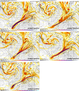
here's where i've landed- we want a mix of both- positive tilt on the southern half and more negative on the northern half. we want the entire trough to look like a bow
View attachment 160870
when the entire feature is more neutrally tilted we get more height rises out ahead of it, which nobody wants, even puts me at risk. however when that entire feature is too positively tilted we get a strung out mess and we're squeezing qpf out of a stone
when the southern half is more positively tilted, it leaves that vort appendage in in baja. I think we want this. GFS and other have been trending this way. adios. i like this trend a lot because when we detach this piece it allows for a cleaner vort down the line. like pruning a crepe myrtle
View attachment 160873
meanwhile a more neutrally tilted northern piece has an easier time digging, advancing eastward and allows for a healthier storm track for everyone in my opinion. this is why i still think we can still trend colder and snowier.
(it took me like 8 attempts to finally write this in a way that made sense, starting from last night lol)
and yeah, i have an ulterior motive. i'm praying for some coastal enhancement. thats how my event goes from good to great. but i think that can be achieved without sacrificing amounts for the rest of the board
moderately encouraged by trends today from my perspective, we're chiseling away more outer ranges and have a healthier consensus

lol….hardly a trend
And still 3 days out. Not good. At all.
lol….hardly a trend
Same can be said about north ga. Really like where we are sittingLooks like northern AL scores on every single model….its been a long time since we have been the sweet spot, but it sure is enjoyable.
Climo..... Know your Climo. N/W of I-85 . Draw a line N GA to NW Raleigh.... theres a historical reference point of 90%I'm fully expecting wobbles and ticks one way or the other. This is a typical thing for it to tick one way and back the other or a couple one way and step back one. My money is on what I said the other day, N of 85 storm. No panic until 24 hours out unless you're 100 miles away.
I love mid level warm advection snow when it’s actually cold enough aloft to keep the warm nose at bay.
Front end thump here tomorrow will probably over perform a little
View attachment 160895
View attachment 160896
100% agree. When you head in the right direction for multiple runs in a row, then all of a sudden things shift 50 miles the opposite direction, there is zero reason to be screaming about it. If it does it run after run, then yes, its time to consider it and figure out what changes have occurred to drive it. Right now, it looks like the SLP was slightly further north, 850mb ridging was slightly increased over the GL's, and the northern stream didn't dig as much.....all very subtle differences from the last run of the Euro. I don't have the ability, but I challenge someone to post a 48 gif of the Euro total snowfall and see how it looks.I would agree that it's definitely not a trend & trust me I am no where close to the guy that is going to get pissed off when someone post something I don't wanna see. But if we have two more ticks from the 18z & 00z Euro North along with other guidance, then I think it's safe to say that we are heading in the wrong direction.
Go back and look at the back & forth over the nearly 250 pages of this thread.. We just spent nearly 24 hours heading in the right direction. The short range guidance is about to full be in range over the next 24 hours. Hopefully the positive trends outweigh the negative trends going forward. This is coming from someone in Columbia that is likely going to see mainly rain.
While not a trend amongst the current models, I think everyone has grown accustom to expecting a N/NW trend with these setups, in the final days. So yes, while it is just one run, it also falls in line with expectations.100% agree. When you head in the right direction for multiple runs in a row, then all of a sudden things shift 50 miles the opposite direction, there is zero reason to be screaming about it. If it does it run after run, then yes, its time to consider it and figure out what changes have occurred to drive it. Right now, it looks like the SLP was slightly further north, 850mb ridging was slightly increased over the GL's, and the northern stream didn't dig as much.....all very subtle differences from the last run of the Euro. I don't have the ability, but I challenge someone to post a 48 gif of the Euro total snowfall and see how it looks.
It's not terrible but definitely ticked north. It's not a trend if it's just one run! But a good reminder to keep expectations in check
View attachment 160892
