Got some pretty good model agreement for a system next weekend. New euro (from what I can tell) continues this trend and actually trended better. CMC has a system and both GFS models have one as well.
-
Hello, please take a minute to check out our awesome content, contributed by the wonderful members of our community. We hope you'll add your own thoughts and opinions by making a free account!
You are using an out of date browser. It may not display this or other websites correctly.
You should upgrade or use an alternative browser.
You should upgrade or use an alternative browser.
Wintry 1/26-1/28 Winter Storm Potential
- Thread starter deltadog03
- Start date
accu35
Member
Let's do this
accu35
Member

Fountainguy97
Member
This timeframe the ensembles are our best friends. Globals will jump a ton but what we need to look for over the next 24-48 hrs is more ensemble support.
So far over the last 24hrs the gefs and eps are both slowly picking up on a coastal threat, many are now showing a more classic Miller A style storm. We want to see this continue today and tomorrow.

One eps member is a january 2000 repeat for Central NC.
Here is the latest gefs run at 06z. See the obvious LP off the NC coast? That is a big improvement on the gefs over the last 4-6 runs and is the trend we want to see

So far over the last 24hrs the gefs and eps are both slowly picking up on a coastal threat, many are now showing a more classic Miller A style storm. We want to see this continue today and tomorrow.
One eps member is a january 2000 repeat for Central NC.
Here is the latest gefs run at 06z. See the obvious LP off the NC coast? That is a big improvement on the gefs over the last 4-6 runs and is the trend we want to see
I will not be able to concentrate on anything else.. Can't get anything done with all this potential. I need medication. Good luck to all") ))
))
))accu35
Member

Fountainguy97
Member
Latest fv3 at 180 is a large improvement.
Fountainguy97
Member
Still 4-5 members dumping snow on NC at this frame as well!Still good support here
accu35
Member

accu35
Member

Up to hour 180. Textbook setup. 
ForsythSnow
Moderator
And that's not even to day 10 which makes it all the better! Finally seeing some more believable trends.Still good support here
Goodnight look at that!!!’
if I reading the old school way. The fv3 is going to be a big hit for me on here.
if I reading the old school way. The fv3 is going to be a big hit for me on here.
Oh yea. Big hit!!!

packfan98
Moderator
Yep. Nice Miller A track on the FV3. Here's the storm totals:

ForsythSnow
Moderator
I'm going to be greedy. Bring this NW! If the run verified I'd me happy since another storm comes 3 days later. I'm sure it'll still be a good show for many and look the Midlands of SC get the goods too!Oh yea. Big hit!!!
View attachment 12038
I am sure it will come NW just a tad. It always does by 50-100 miles.I'm going to be greedy. Bring this NW! If the run verified I'd me happy since another storm comes 3 days later. I'm sure it'll still be a good show for many and look the Midlands of SC get the goods too!
Showmeyourtds
Member
Wow. Hard to ask for a better LP track for MS/AL/GA on that run.
Chris is going to bring the magic
Chris is going to bring the magic
Showmeyourtds
Member
And this might be me just grasping at straws here, but if there’s anything I’d be concerned about in GA regarding the FV3, it’s BL temps. I suppose based on the initial track of the low, there would be a little WAA.
I know it’s only 1 run & temps are always gonna be iffy around here.
I know it’s only 1 run & temps are always gonna be iffy around here.
Fountainguy97
Member
And this might be me just grasping at straws here, but if there’s anything I’d be concerned about in GA regarding the FV3, it’s BL temps. I suppose based on the initial track of the low, there would be a little WAA.
I know it’s only 1 run & temps are always gonna be iffy around here.
Yeah globals wont get remotely “reliable” until Tuesday. By then it’ll be in that 144-160hr range when globals become more stable.
But good trends on ensembles and nice to see an OP model throw out a good hit.
Snowman63
Member

Kylo
Member
Moving this post to here.
Pretty cool to see a full hemispheric trough/low over the arctic...the cold is going to push really far south.
.png")

Whenever I see that it makes me think of that little event that occurred in March in the early 90's. Most people probably don't remember, especially the ones living in at Atlanta. Yeah, I know this isn't a TP but still.

Pretty cool to see a full hemispheric trough/low over the arctic...the cold is going to push really far south.
Whenever I see that it makes me think of that little event that occurred in March in the early 90's. Most people probably don't remember, especially the ones living in at Atlanta. Yeah, I know this isn't a TP but still.
Last edited:
Jessy89
Member
A nw trend hopefully happens. But not enough of one to bring in waa. I’d like it to be a board wide snow
Sent from my iPhone using Tapatalk
Sent from my iPhone using Tapatalk
Kylo
Member
EPS snow mean jumped from 0z run.
.png")
atlantasweetie
Member
I remember the "storm of the century", if that's what you are referring to. Quite the storm for sure.Moving this post to here.
Pretty cool to see a full hemispheric trough/low over the arctic...the cold is going to push really far south.
View attachment 12056View attachment 12057
Whenever I see that it makes me think of that little event that occurred in March in the early 90's. Most people probably don't remember, especially the ones living in at Atlanta. Yeah, I know this isn't a TP but still.
View attachment 12055
Sent from my ONEPLUS A3000 using Tapatalk
Just a little bit of cross-polar flow showing up there.Moving this post to here.
Pretty cool to see a full hemispheric trough/low over the arctic...the cold is going to push really far south.
View attachment 12056View attachment 12057
Whenever I see that it makes me think of that little event that occurred in March in the early 90's. Most people probably don't remember, especially the ones living in at Atlanta. Yeah, I know this isn't a TP but still.
View attachment 12055
Did it increase from 12z yesterday??
Yellow Snow
Member
I've just recently started playing with the Euro maps from Dr. Maue's website - you can zoom down to state and local level...
Man I hate that color scale. Sometimes it’s easy to forget that’s a 50 member mean. Let’s try and keep this party barge sailing in the right direction for the rest of the day
Last edited:
Kylo
Member
Did it increase from 12z yesterday??
Yes, here are the past 3 runs with 24 hour precip panels


Kylo
Member
Member 30 with March 93 repeat

drfranklin
Member
- Joined
- Dec 1, 2016
- Messages
- 511
- Reaction score
- 760
as a former resident of Nashville/Memphis/Birmingham, the upcoming storm potentials look promising for the Mid-South
(Nashville is due for a major snowfall)
not sure about the I-85 corridor from ATL to GSP to GSO but I think its too early to discuss mesoscale
rooting for a MGM-MCN-CAE-ILM crush!
(Nashville is due for a major snowfall)
not sure about the I-85 corridor from ATL to GSP to GSO but I think its too early to discuss mesoscale
rooting for a MGM-MCN-CAE-ILM crush!
Kylo
Member
That’s a big mean with several members for ATL this far out

Scooter
Member
Looking at the maps of the cross polar flow Kylo shared, how long could the cold from this last? Would this also help.pump up the ridge out west even more?
That isn't likely, but I'll start believing it if the major OP models show that. There hasn't been anything on the OP models (yet) of that magnitude.
Round Oak Weather
Member
This is the most beautiful thing I’ve ever seen snow all the way to Tifton keeping me from having to go back to school nxt Monday. It won’t happen like that but I like the trends in the models hits a lot of people who haven’t and probably never will see that much snow in their lifetime with a big storm.
Attachments
B
Brick Tamland
Guest
Awesome to see the FV3 on board. It did great with the December storm. The GEFS continues to increase totals, too. This really looks like a legit threat. I am a believer now. Let's reel in this bad boy.
Kylo
Member
Awesome to see the FV3 on board. It did great with the December storm. The GEFS continues to increase totals, too. This really looks like a legit threat. I am a believer now. Let's reel in this bad boy.
It sure is

ALL IN on thatOh yea. Big hit!!!
View attachment 12038
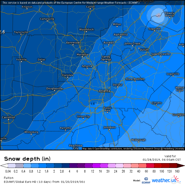
What's with the relative "snow hole" around ATL?