• Hello, please take a minute to check out our awesome content, contributed by the wonderful members of our community. We hope you'll add your own thoughts and opinions by making a free account!

Wintry Winter Mischief For Upper SE 3/12/18

That is a decent hit. Maybe this will be a situation where things get better as we get closer to the storm arriving.

Accounting for melting due to warm ground temps these totals are at least slashed in half and there's a widespread T-1 amounts with some isolated 1-2 further east where it snowed longer. I would take it in either case.
nam3km_asnowd_seus_54.png
 
Accounting for melting due to warm ground temps these totals are at least slashed in half and there's a widespread T-1 amounts with some isolated 1-2 further east where it snowed longer. I would take it in either case.
View attachment 4437
Yeah, an inch in March is a win. I am just hoping to get some time off work tomorrow.
 
Here's my first crack at this storm, should be a low impact event overall w/ any snow/sleet mainly confined north of US 64, some flakes or sleet pellets could mix in south & east of there towards Charlotte and Fayetteville
March 12-13 2018 NC Snow Forecast.png
 
Here's my first crack at this storm, should be a low impact event overall w/ any snow/sleet mainly confined north of US 64, some flakes or sleet pellets could mix in south & east of there towards Charlotte and Fayetteville
View attachment 4438
Not a bad first call map... Pretty much in line with guidance. This one has bust potential either way.
 
A casual 2.6”/hr maximum snowfall rate for NW of Wake Co. on the 3km NAM
 

Attachments

  • 72CC75FD-70BB-4C86-8D9C-25B2AC00741A.png
    72CC75FD-70BB-4C86-8D9C-25B2AC00741A.png
    144.5 KB · Views: 32
Not a bad first call map... Pretty much in line with guidance. This one has bust potential either way.

I just don't think this has large bust potential on the upper end at least not yet anyways, I will be shocked if anyone east of the mountains tops out over 2-3". The selling point for me to go conservatively on the snowfall totals east of the mountains is the fact we'll have to erode a very stout +5-7C warm nose. Even w/ robust low-level cold air advection and melting hydrometeors cooling the low-levels on the backside of the low, once the CAA sets in and the mid-level warm nose begins to erode, turbulent mixing will offset these cooling processes as the entire low-mid level layer becomes effectively homogenized, keeping the low levels from getting too much colder than they would otherwise and the propensity for sleet mixing in (which will have ratios of ~2-3:1) will further hamper any snow accumulation.

Just accounting for melting, the snow accumulations are heavily dampened w/ only a few isolated spots getting 1-2". This map doesn't consider mixing w/ sleet (but does consider melting & compaction) and if you do so, these accumulations shown below will be cut by at least half or two-thirds.
download (4).png
nam3km_asnowd_seus_59.png
 
Last edited:
I just don't think this has large bust potential on the upper end at least not yet anyways, I will be shocked if anyone east of the mountains tops out over 2-3". The selling point for me to go conservatively on the snowfall totals east of the mountains is the fact we'll have to erode a very stout +5-7C warm nose. Even w/ robust low-level cold air advection and melting hydrometeors cooling the low-levels on the backside of the low, once the CAA sets in and the mid-level warm nose begins to erode, turbulent mixing will offset these cooling processes as the entire low-mid level layer becomes effectively homogenized, keeping the low levels from getting too much colder than they would otherwise and the propensity for sleet mixing in (which will have ratios of ~2-3:1) will further hamper any snow accumulation.

Just accounting for melting, the snow accumulations are heavily dampened w/ only a few isolated spots getting 1-2". This map doesn't consider mixing w/ sleet (but does consider melting & compaction) and if you do so, these accumulations shown below will be cut by at least half or two-thirds.
View attachment 4440
View attachment 4441

You can further add onto the fact that not only will ground temps be warm, many areas will be covered in or saturated w/ water from preceding rainfall. Given water's high heat capacity, this means it's actually harder to cool warm, saturated soil to the freezing than warm dry soil. Therefore, a larger proportion of the latent heating from melting snow flakes and sleet pellets that try to cool the ground to freezing will go into cooling the water laying within or on top of the ground rather than the ground itself, further hampering snow/sleet accumulations in east-central NC.
 
The fact that Roxboro could get more than DC metro and most of the MA, and it skips up the coast and backs in to give BOS another foot+, and NYC possibly 6”+, is fantastic
 
You can further add onto the fact that not only will ground temps be warm, many areas will be covered in or saturated w/ water from preceding rainfall. Given water's high heat capacity, this means it's actually harder to cool warm, saturated soil to the freezing than warm dry soil. Therefore, a larger proportion of the latent heating from melting snow flakes and sleet pellets that try to cool the ground to freezing will go into cooling the water laying within or on top of the ground rather than the ground itself, further hampering snow/sleet accumulations in east-central NC.
I had all these problems in March 1 2009, still got 8”! Different setup/ time of year, yadda, but wet ground, sun angle, all overrated
 
I had all these problems in March 1 2009, still got 8”! Different setup/ time of year, yadda, but wet ground, sun angle, all overrated

March 2009 also didn't have to contend with a huge warm nose aloft that will keep the heaviest precipitation in the form of sleet/rain or sleet/snow rather than pure wet snow here and the heaviest precipitation came during the overnight hours in this event instead of the middle of the afternoon like what's liable to occur in this instance.
se.bref.0903020001.gif
 
Last edited:
March 2009 also didn't have to contend with a huge warm nose aloft that will keep the heaviest precipitation in the form of sleet/rain or sleet/snow rather than pure wet snow here and the heaviest precipitation came during the overnight hours in this event instead of the middle of the afternoon like what's liable to occur in this instance.
View attachment 4442

Yeah. Brutal timing for Central NC. One has to consider sun angle with this one even though I hate the mention of those two words. Not much working for us with this storm, although with the heaviest band the warm nose should erode rather quickly on exit...will be nice looking, but the ground surely won’t reflect the rates seen in those bands. I’d love to get some heavy rates...the timing later now make it after work for me so I’ll chase the rates if it’s within a 1hr drive. Lol


Sent from my iPhone using Tapatalk
 
Nice potential for Brick & company to see some snow falling even if little sticking! This March is living up to its mag/marv buildup! The first half of March has surely been magnificent here!!
 
I just want to see some snow falling instead of more rain. And the threat of snow could always send me home early from work.
 
HREF ensemble mean QPF and precipitation type thru 36 hours. Diurnal timing will hurt RDU.
output_XDeGgd.gif
 
HREF ensemble mean QPF and precipitation type thru 36 hours. Diurnal timing will hurt RDU.
output_XDeGgd.gif
Of course it has to be an hour or 2 too slow for a chance here unless there are heavier rates, which I doubt will develop until it's past here. Maybe I'll get lucky and see a few flakes, but if not, it's not a big loss. Just glad the MA is getting skipped for the most part.
 
Of course it has to be an hour or 2 too slow for a chance here unless there are heavier rates, which I doubt will develop until it's past here. Maybe I'll get lucky and see a few flakes, but if not, it's not a big loss. Just glad the MA is getting skipped for the most part.
Whether anyone sees a flake or not, it's just incredible, after February, to even see a hint on the modeling.
One thing's for sure, through the 16th at least, we all have some nice temps to enjoy ... :cool:
 
Feb 1-10 KSAV mean: 56.5
Mar 1-10 KSAV mean: 55.8

But wait til we get through the 17th to see that much more impressive comparison!
 
Verbatim this is an inch or so from I85 and points west token flakes elsewhere. Timing was a little better for RDU vs other high res guidance with heavier precip coming in closer to dusk but it’s still not good
View attachment 4444
Yeah, I’m hoping for snow tv with a slushy heavy dusting to a half inch on the high end.
 
I always love these type of storms where it's really hard to pin down how much or how little snow will fall. It seems middle Kentucky is this place to be but I feel pretty good where I'm at in far northern middle Tennessee. This is definitely one of those situations where it could easily over perform or completely whiff. Honestly if if get a sloppy wet half inch that sticks to the trees I'll be happy.
 
Verbatim this is an inch or so from I85 and points west token flakes elsewhere. Timing was a little better for RDU vs other high res guidance with heavier precip coming in closer to dusk but it’s still not good
View attachment 4444
It was a slight improvement from 0z I believe. Either way if I can get a burst of moderate snow around dusk on March 12 if only for half hour or so #winning

Sent from my SM-G920V using Tapatalk
 
I always love these type of storms where it's really hard to pin down how much or how little snow will fall. It seems middle Kentucky is this place to be but I feel pretty good where I'm at in far northern middle Tennessee. This is definitely one of those situations where it could easily over perform or completely whiff. Honestly if if get a sloppy wet half inch that sticks to the trees I'll be happy.

Maybe you can get under something like this starting to get RN/SN mix in circled area... Imagine the rates they will be seeing soon
9EE36F4F-228C-4554-AC97-3981DCD37ECD.jpeg
 
Screen Shot 2018-03-11 at 3.35.27 PM.png
URGENT - WINTER WEATHER MESSAGE
National Weather Service Raleigh NC
325 PM EDT Sun Mar 11 2018

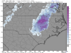
...Rain will transition to a wintry mix across the northern
Piedmont of North Carolina Monday...

.Rain will transition to a mixture of rain, sleet, and heavy wet
snow Monday morning. With surface temperatures hovering near
to just above freezing, significant accumulations are not
expected, however, a period of slush will likely accumulate once
precipitation rates increase. A few slick spots will be possible,
especially in areas along and north of Interstate 85 in the late
afternoon and evening hours.

NCZ007>010-021>025-121100-
/O.NEW.KRAH.WW.Y.0005.180312T1200Z-180313T0000Z/
Person-Granville-Vance-Warren-Forsyth-Guilford-Alamance-Orange-
Durham-
Including the cities of Bushy Fork, Concord, Roxboro, Surl,
Oxford, Butner, Creedmoor, Dabney, Henderson, Norlina, Wise,
Afton, Warrenton, Lake Gaston, Pfafftown, Stanleyville,
Winston-Salem, Greensboro, Lake Townsend, High Point, Burlington,
Graham, Chapel Hill, Carrboro, Bethesda, Durham,
and Research Triangle
325 PM EDT Sun Mar 11 2018

...WINTER WEATHER ADVISORY IN EFFECT FROM 8 AM TO 8 PM EDT
MONDAY...

* WHAT...A mixture of rain, sleet, and wet snow expected. Total
snow/sleet accumulations of up to two inches will be possible,
with localized higher amounts.

* WHERE...The Northern Piedmont Counties of central North
Carolina.

* WHEN...From 8 AM to 8 PM EDT Monday.

* ADDITIONAL DETAILS...Plan on slippery road conditions,
including during the evening commute on Monday. Be prepared
for reduced visibilities at times.

PRECAUTIONARY/PREPAREDNESS ACTIONS...

A Winter Weather Advisory for wet snow means periods of wet snow
will cause primarily travel difficulties. Be prepared for snow
covered roads and limited visibilities, and use caution while
driving. The latest road conditions for North Carolina can be
found online at DriveNC.gov.
 
Nashville finally pulled the trigger on a winter weather advisory. The local news and weather forecasted snow totals have slowly been increasing since yesterday. At first it was a dusting at most. Then a dusting to a half inch. Then a half inch to an inch. And now up to 2 inches.IMG_0008.jpg
 
Nashville finally pulled the trigger on a winter weather advisory. The local news and weather forecasted snow totals have slowly been increasing since yesterday. At first it was a dusting at most. Then a dusting to a half inch. Then a half inch to an inch. And now up to 2 inches.View attachment 4448
Just make sure you wake up early so that you will see it before it melts. With temps between 45 and 50 tomorrow in North TN it will be a distant memory by afternoon.
 
I'll be driving through Kentucky tomorrow but I'm confident that with sunny skies and temps well above freezing the roads should be fine.
 
Just to show you how ------ the SHREF plumes are . Found this golden post in the MA thread LMAO
3c90674e58747a41d157982b63204e68.jpg


Sent from my SM-J327VPP using Tapatalk
 
  • Like
Reactions: Jon
Back
Top