• Hello, please take a minute to check out our awesome content, contributed by the wonderful members of our community. We hope you'll add your own thoughts and opinions by making a free account!

Wintry Winter 26-27

I'm interested to see the next QBO reading. If it takes a significant drop, that would be good.

Yeah Dave Tolleris with WxRisk said it’s only went above 14 a handful of times in the last 100 years or whatever so odds are it’ll come down some which will be interesting
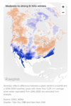
It will very likely still be +5 or higher at 30 mb through Feb and could even still be ~+10 at 30 mb (the level which is most followed) even in Feb based on my own analysis of past patterns and what’s going on now. My best guess right now for it to first go <0 is ~May. This is why I feel that 2015-6, 1982-3, and 1957-8 are easily the best analogs for super Ninos.

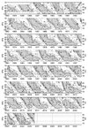
History:
IMG_2888.jpeg

Recent pointing to +5+ at 30 mb through Feb per historical patterns:
IMG_2888.jpeg
 
It will very likely still be +5 or higher at 30 mb through Feb and could even still be ~+10 at 30 mb (the level which is most followed) even in Feb based on my own analysis of past patterns and what’s going on now. My best guess right now for it to first go <0 is ~May. This is why I feel that 2015-6, 1982-3, and 1957-8 are easily the best analogs for super Ninos.

History:
View attachment 199094

Recent pointing to +5+ at 30 mb through Feb per historical patterns:
View attachment 199095
Larry, if we get cold in late February or march, it will mainly benefit north of most of us, especially with increasing sunlight. Higher elevations may do okay. Hopeful we can get shifts or changes that would help us more than people think currently
 
The one thing I’d be interested to see is how this stratospheric warming event impacts December.

Certainly on the board that we get something less torch-y and more like 1997 than the canonical mega torch super Nino composite

All it would take is for one of these in-situ -NAO blocks in the extended to get anchored to the stratosphere and it would be hard to get rid of it
Still say December wind up above average temp wise . January average . February will be below average …. Sticking to my winter prediction. The ssw events don’t always work in our favor be honest
 
The one thing I’d be interested to see is how this stratospheric warming event impacts December.

Certainly on the board that we get something less torch-y and more like 1997 than the canonical mega torch super Nino composite

All it would take is for one of these in-situ -NAO blocks in the extended to get anchored to the stratosphere and it would be hard to get rid of it
IMG_2486.gif
IMG_2487.png👀
 
The one thing I’d be interested to see is how this stratospheric warming event impacts December.

Certainly on the board that we get something less torch-y and more like 1997 than the canonical mega torch super Nino composite

All it would take is for one of these in-situ -NAO blocks in the extended to get anchored to the stratosphere and it would be hard to get rid of it
I’ve been looking at some of the KCLT climate data from October to December 1997 lately and was wondering if there had been a SSWE that contributed to the numbers I was seeing. There was a significant snowstorm for the mid south early in the month and then much of us had a significant snowstorm a few days after Christmas. It actually seems we’ve been following a progression similar to 1997.
 
I’ve been looking at some of the KCLT climate data from October to December 1997 lately and was wondering if there had been a SSWE that contributed to the numbers I was seeing. There was a significant snowstorm for the mid south early in the month and then much of us had a significant snowstorm a few days after Christmas. It actually seems we’ve been following a progression similar to 1997.


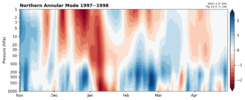
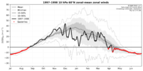
Ironically, there was a stratospheric warming event (a minor one) in early January 1998, but late winter was much warmer than December despite the -NAM in January.

A lot of times in these big Ninos, a stratospheric warming event can backfire on you.


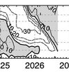
nam_ndjfma_1998.png

era5_u1060n_1998.png


Larry Cosgrove​

unread,
4:41 AM (3 hours ago)


to [email protected]
EXTENDED PERIOD FORECAST
(Between Day 11 And Day 15)


Increasing Siberian Snow/Ice Cover. Stratospheric Warming, Repeated High-Latitude Ridge Development. And Just Where Is The Famed El Nino Southern Branch/Pineapple Express?


As many of you know by now, the "Super El Nino" weather gods had late fall and winter already mapped out, with cries of "warmest winter ever" and "no named storms". Of course that kind of extreme talk is proving unlikely to verify, mostly because the very warm Equatorial Pacific Ocean is NOT the only determinant in creating apparent weather and some inevitable quirks in the global pattern are showing us that this season is in many ways different than the climatology of high profile +ENSO episodes.

The unusual cold and storminess in the Southern Hemisphere is telling us that rather than the normal fall/winter orientation of energy and moisture into areas above the Equator, systems below the central latitude line are linking with the Madden-Julian Oscillation and other tropical features. Conversely, the Northern Hemisphere was largely left to drier, hotter results (still going on in North America) despite the many cases where the 500MB flow would be laden with shortwaves and thunderstorm production could be quite high. At some point, with the sun angle dropping and the ground losing heat, surface temperatures will start to drop. But for that to happen, we need to see an increase in storms at low latitudes as well as blocking signatures close to and above the Arctic Circle in Alaska, Canada, and Greenland.

And that could happen, given that most of the numerical model guidance shows a significant stratospheric warming event. At 10MB, distortion of the temperature and height anomalies would favor a very strong ridge and warming from the North Pole to the Arctic Circle on the American side about two to four weeks after November 10. Keep in mind that the downstream and lower level changes are always delayed; a mistake often seen is that viewers of the higher-latitude Canadian warming think that cold drainage to the south and east of the imprinted 500MB ridge is immediate.

We need to lay down some serious snowfall in Siberia and build the ice cap over the Arctic waters. So far, every location in the Northern Hemisphere to the polar regions has been routinely mild or warm. Typically, the snow cover expands south and north out of Russia. There are signs that the "first step" in creating a new cryosphere is beginning:
Current Progress & Timeline
    • Early October: Snow advance trailed slightly behind normal historical ranges due to initial mild conditions.
    • Mid-to-Late October: A dramatic expansion across Siberia and core Eurasian sectors caught up quickly, moving snowpack levels to near-to-above the historical October average.
    • Ranking: Projections from the European Centre for Medium-Range Weather Forecasts (ECMWF) place this late-month snow acceleration roughly in the top 15% for the last three decades.

Atmospheric & Winter Implications

    • Siberian Snow Influence: Rapid October snow growth across Siberia is actively monitored by meteorologists as a potential driver for the Arctic Oscillation (AO), the Siberian High, and the stratospheric polar vortex later in the winter.
    • Broader Context: While robust Eurasian snow signals can favor colder patterns in parts of the Northern Hemisphere, forecasters note that it interacts with an active El Niño footprint, leading to a mixed regional outlook rather than a single guaranteed winter outcome.

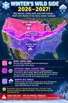
I do not think that we will see the traditional, 66% chance of a hyper-split flow this fall and winter. And with a storm track that starts first in southern Canada, and gradually shifts into northern Mexico, the Deep South and then to just left of the Gulf Stream. conditions will change gradually to a cold/stormy alignment in the last week of January through most of March. Until then, relative warmth and occasional liquid precipitation will rule across much of the lower 48 states.

 

​

Larry Cosgrove​

unread,
4:41 AM (3 hours ago)


to [email protected]
EXTENDED PERIOD FORECAST
(Between Day 11 And Day 15)


Increasing Siberian Snow/Ice Cover. Stratospheric Warming, Repeated High-Latitude Ridge Development. And Just Where Is The Famed El Nino Southern Branch/Pineapple Express?

As many of you know by now, the "Super El Nino" weather gods had late fall and winter already mapped out, with cries of "warmest winter ever" and "no named storms". Of course that kind of extreme talk is proving unlikely to verify, mostly because the very warm Equatorial Pacific Ocean is NOT the only determinant in creating apparent weather and some inevitable quirks in the global pattern are showing us that this season is in many ways different than the climatology of high profile +ENSO episodes.

The unusual cold and storminess in the Southern Hemisphere is telling us that rather than the normal fall/winter orientation of energy and moisture into areas above the Equator, systems below the central latitude line are linking with the Madden-Julian Oscillation and other tropical features. Conversely, the Northern Hemisphere was largely left to drier, hotter results (still going on in North America) despite the many cases where the 500MB flow would be laden with shortwaves and thunderstorm production could be quite high. At some point, with the sun angle dropping and the ground losing heat, surface temperatures will start to drop. But for that to happen, we need to see an increase in storms at low latitudes as well as blocking signatures close to and above the Arctic Circle in Alaska, Canada, and Greenland.

And that could happen, given that most of the numerical model guidance shows a significant stratospheric warming event. At 10MB, distortion of the temperature and height anomalies would favor a very strong ridge and warming from the North Pole to the Arctic Circle on the American side about two to four weeks after November 10. Keep in mind that the downstream and lower level changes are always delayed; a mistake often seen is that viewers of the higher-latitude Canadian warming think that cold drainage to the south and east of the imprinted 500MB ridge is immediate.

We need to lay down some serious snowfall in Siberia and build the ice cap over the Arctic waters. So far, every location in the Northern Hemisphere to the polar regions has been routinely mild or warm. Typically, the snow cover expands south and north out of Russia. There are signs that the "first step" in creating a new cryosphere is beginning:
Current Progress & Timeline
    • Early October: Snow advance trailed slightly behind normal historical ranges due to initial mild conditions.
    • Mid-to-Late October: A dramatic expansion across Siberia and core Eurasian sectors caught up quickly, moving snowpack levels to near-to-above the historical October average.
    • Ranking: Projections from the European Centre for Medium-Range Weather Forecasts (ECMWF) place this late-month snow acceleration roughly in the top 15% for the last three decades.

Atmospheric & Winter Implications
    • Siberian Snow Influence: Rapid October snow growth across Siberia is actively monitored by meteorologists as a potential driver for the Arctic Oscillation (AO), the Siberian High, and the stratospheric polar vortex later in the winter.
    • Broader Context: While robust Eurasian snow signals can favor colder patterns in parts of the Northern Hemisphere, forecasters note that it interacts with an active El Niño footprint, leading to a mixed regional outlook rather than a single guaranteed winter outcome.

I do not think that we will see the traditional, 66% chance of a hyper-split flow this fall and winter. And with a storm track that starts first in southern Canada, and gradually shifts into northern Mexico, the Deep South and then to just left of the Gulf Stream. conditions will change gradually to a cold/stormy alignment in the last week of January through most of March. Until then, relative warmth and occasional liquid precipitation will rule across much of the lower 48 states.
My thinking all along .
 
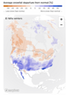
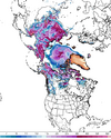
Siberian snow cover (October increase) has done ok. I think the theory goes on the assumption if the month of October has a big increase in snow coverage, that would signal a cold winter for the eastern US (I think). So looking at the 6z GFS, it does look like Siberia has done some good catchup from earlier in the month. Here is snow depth for the last day of October:
1792933430865.png
It would be nice to see a little more coverage in NW part of Russia and of course on our side of the world.
 
Siberian snow cover (October increase) has done ok. I think the theory goes on the assumption if the month of October has a big increase in snow coverage, that would signal a cold winter for the eastern US (I think). So looking at the 6z GFS, it does look like Siberia has done some good catchup from earlier in the month. Here is snow depth for the last day of October:
View attachment 199123
It would be nice to see a little more coverage in NW part of Russia and of course on our side of the world.
Lacking pretty bad still actually.
 
So far, the models, especially the ecmwf is on the bandwagon for some unprecedented strat warming. Its been showing it for a while now. Be interesting to see if it actually materialized, especially with this strong niño we have currently. Typically, depending on what type of warming, it can take 2-4 weeks to feel any effects on the surface and it also depends on where the cold goes.
 
So far, the models, especially the ecmwf is on the bandwagon for some unprecedented strat warming. Its been showing it for a while now. Be interesting to see if it actually materialized, especially with this strong niño we have currently. Typically, depending on what type of warming, it can take 2-4 weeks to feel any effects on the surface and it also depends on where the cold goes.
Like Webber sai could work against us also . It be late January till we get legit cold enough . Then not seeing any major artic intrusion making to far south this winter .
 
So far, the models, especially the ecmwf is on the bandwagon for some unprecedented strat warming. Its been showing it for a while now. Be interesting to see if it actually materialized, especially with this strong niño we have currently. Typically, depending on what type of warming, it can take 2-4 weeks to feel any effects on the surface and it also depends on where the cold goes.

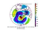
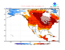
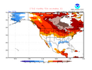
Quite possibly related to this progged even further weakening of the SPV to record weak levels (records back to 1978-9) for early Nov and unlike the recent 2-3F Nov warming on the CFS, Dec 10 day mean CFS forecasts have done the opposite since 10 days ago with 2F of cooling in the E US:

CFS 10 day mean as of 10 days ago:
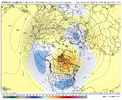
IMG_3124.png

Current CFS 10 day mean (2F colder):
IMG_3125.png
 
Quite possibly related to this progged even further weakening of the SPV to record weak levels (records back to 1978-9) for early Nov and unlike the recent 2-3F Nov warming on the CFS, Dec 10 day mean CFS forecasts have done the opposite since 10 days ago with 2F of cooling in the E US:

CFS 10 day mean as of 10 days ago:
View attachment 199129

Current CFS 10 day mean (2F colder):
View attachment 199130
Normally I would doubt this type of event happening, but the euro has been on the bandwagon for many days about it. It ultimately may not mean much in the grand scheme of things, but interesting nonetheless. As long as we can a few weeks of winter, I will be content. If this event is legit, models will adjust sooner or later
 
Normally I would doubt this type of event happening, but the euro has been on the bandwagon for many days about it. It ultimately may not mean much in the grand scheme of things, but interesting nonetheless. As long as we can a few weeks of winter, I will be content. If this event is legit, models will adjust sooner or later
Need doubt it , if you don’t you going be highly disappointed like a kid on Christmas morning who did not get want they wanted for Christmas ….
 
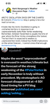
Sign me up for whatever Judah is smokin’ View attachment 199137
Judah is right about it being unprecedented *if* this did transpire. What is currently impractical is anyone guaranteeing any specific outcome from this, particularly in terms of severe US winter weather impacts downstream, which would certainly be putting the cart before the horse at this juncture before we really know if it’s even going to happen.
 
I’ve been looking at some of the KCLT climate data from October to December 1997 lately and was wondering if there had been a SSWE that contributed to the numbers I was seeing. There was a significant snowstorm for the mid south early in the month and then much of us had a significant snowstorm a few days after Christmas. It actually seems we’ve been following a progression similar to 1997.
Remember that event. A couple of inches on the 22nd. A few weeks later was that huge Boone snowstorm.
 
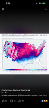
Overnight CFS Really gets the ole Pressure's up over Greenland as you roll through November. Starts evolving week 1 and continues out to Turkey slicing day. PV takes a hit. See if this trend continues to show up.

Hate to repeat the bad news / but the Doughnut hole ( drought= near 0 qpf ) still showing on the foreign guidance models next 200 hours. Euro op did get us in the 1 inch camp out day 11-15 ish ( late 1st week of NOV ).

Seems like with the PV getting disrupted/ stretched, that should cause the deck to shuffle and get us out of this qusai stationary pattern we are locked into. Need Rain. If not for the Rain needed/ This wx pattern is just about as good as it gets for doing anything outdoors. Feel bad rooting for the change up.
 
I'm going to be  that guy... some of you are setting yourselves up for MASSIVE disappointment and heartache this winter. Don't fall for clown maps. Just remember, the rest of us will be here to support you when reality delivers it's dose of kicking you where it hurts.
As soon as it's 75° we're going to hear it from you :)
 
Latest CFS Run is Bueno for November: ( tracking Trends / not gospel fantasy range )
11/12 has snow in northern NC Border Counties
11/18 has more snow Northern NC as it turns into a snowbomb MA/NE
BY 11/23 has the 520 thickness line all the way down into NC. Monster freeze all SE / probably into Florida.

This is how you draw it up boys heading into late Nov / start of Met winter a week out.

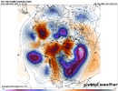
1793099264331.png
 
Latest CFS Run is Bueno for November: ( tracking Trends / not gospel fantasy range )
11/12 has snow in northern NC Border Counties
11/18 has more snow Northern NC as it turns into a snowbomb MA/NE
BY 11/23 has the 520 thickness line all the way down into NC. Monster freeze all SE / probably into Florida.

This is how you draw it up boys heading into late Nov / start of Met winter a week out.

View attachment 199142
That's a great look, I just wish it would hold off until later Dec into Jan. Maybe it will repeat?!?!
 
That's a great look, I just wish it would hold off until later Dec into Jan. Maybe it will repeat?!?!
I've always thought that the pattern in late November and early December set the tone for the whole winter. This would at least give me some hope.
 
Back
Top