• Hello, please take a minute to check out our awesome content, contributed by the wonderful members of our community. We hope you'll add your own thoughts and opinions by making a free account!

Wintry More SE Snow ? (1/16-1/18)

The only saving face for us is if we can get heavier precipitation rates. 1300m & WEbb also alluded to it being an issue down here.
I'm not looking for anything maybe wet flakes mixed in and a flurry at very end
 
Live thread is off, due to very high traffic in this thread currently.
 
It could be more in some spots, especially northside (as much as an inch), but it won't be anything near the 3-4+ that BPATL just mentioned a few posts above.

Edit: The euro has nothing for ATL or nearby.
Should we even trust the Euro at this range?
 
I don't see this having anything even close to the moisture potential of 12/8/17. That being said, the problem here is that even a dusting could cause driving problems since it would be much colder than 12/8/17.
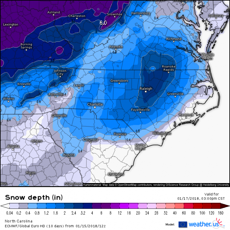
That and much higher ratios.


Sent from my iPhone using Tapatalk
 
Euro goes boom for Raleigh to Roanoke Rapids!

us_model-en-087-0_modez_2018011512_57_480_215.thumb.png.7ec4340ae59ecdb49f351192f6fe5414.png
 
Really think anywhere from Charlotte to Roanoke Rapids can be the sweet spot. The models have been showing various spots. Euro looks between the GFS and NAM, and like the UK.
 
Should we even trust the Euro at this range?

No, but it gives an indication that moisture is limited and that durations should be pretty short. So, even with high ratios, I'd say ~1" tops ATL area with that more likely northside. But anything could be dangerous. Anything measurable would be a pretty big deal.

What are you predicting?
 
Euro not buying the ptype concerns for NC/SC, nor am I. To be fair, if it came in later then it could briefly start as rain/snow mix, but it would rapidly changeover for most even in that scenario.

View attachment 2961
The ICON & CMC hold off on the precipitation til 18z which is part of the reason why they're so much warmer than the Euro in the boundary layer. Sure their sfc temps may be overdone but if the timing of the s/w and precipitation is slower that will favor a warmer BL than the Euro is advertising at the onset of the event. Timing is key to minimize p-type issues
icon_mslp_pcpn_frzn_seus_18.png
gem_mslp_pcpn_frzn_seus_9.png
 
No, but it gives an indication that moisture is limited and that durations should be pretty short. So, even with high ratios, I'd say ~1" tops ATL area with that more likely northside. But anything could be dangerous. Anything measurable would be a pretty big deal.

What are you predicting?
I would probably be on the safe side like you and say up to an inch. Until we get closer we won't really know either. Certainly much different than last month with plenty of cold around.
 
For the KCAE guys, outside the temperature problems, the total precipitation is still only 0.05 - 0.08, That is literally only 5-8 one hundredths of an inch. We need more/heavier to stay predominantly snow.

0.25 + is almost a necessity here.
 
Can these snow hole comments go to banter? I would be surprised if it happened exactly as modeled.
Why filter out the bad when it's showing on the models. These threads aren't here to cheer on the existence of snow, they are here to discuss weather and the snow hole has shown on models for a while now. It's valid discussion for this weather thread.
 
Allan Huffman's first call forecast snow map. I strongly agree with this in general, if there's any small caveat it's the potential for additional snowfall in the western facing slopes of the mountains.
View attachment 2965
I think higher totals could come further east like the Euro and UK are showing now. I know the GFS or NAM have the higher totals further west, but also further south than that, while the other one has it further east but north of Roanoke Rapids. Would love to see a large area from Charlotte to Roanoke Rapids with 3 to 6 inches, though. I think that's possible, too.
 
BMX mentions the possibility of 15:1 ratios and how the forecast amounts could be underdone.

These
amounts do not meet our 2 inch criteria for a Winter Storm Watch,
but impacts to travel are expected to be significant due to
temperatures in the 20s as the snow occurs. With saturated
profiles and efficient snow ratios of 15:1, snowfall amounts could
easily be underdone if models are underplaying the amount of lift.
 
I wouldn't worry about the European at this point that much, only because it's not the greatest short-term model. I'm not saying completely throw it out, but rely on more higher-res short-term models for sure

I put some numbers together from various modeling around the CAE area to keep track of qpf, and so far have this on today's 12z (which is a reoccuring theme so far):

GFS - 0.01
NAM - 0.05
EURO - 0.02 - 0.05
SREF Mean - 0.05
ICON - 0.05 - 0.1
 
I think higher totals could come further east like the Euro and UK are showing now. I know the GFS or NAM have the higher totals further west, but also further south than that, while the other one has it further east but north of Roanoke Rapids. Would love to see a large area from Charlotte to Roanoke Rapids with 3 to 6 inches, though. I think that's possible, too.

Care to share what you're seeing that supports the higher qpf totals and location? Curious why you think that
 
Care to share what you're seeing that supports the higher qpf totals and location? Curious why you think that
Just because the models have all shown the higher totals somewhere between Charlotte and Roanoke Rapids in various places. Euro and UK had it between Raleigh and Roanoke Rapids their last runs. If you blend them all it would be somewhere between Charlotte and Roanoke Rapids. Hoping it ends up being that whole area.
 
I put some numbers together from various modeling around the CAE area to keep track of qpf, and so far have this on today's 12z (which is a reoccuring theme so far):

GFS - 0.01
NAM - 0.05
EURO - 0.02 - 0.05
SREF Mean - 0.05
ICON - 0.05 - 0.1
I hear ya. Let's be honest it doesn't look great for our areas but a dusting will stick to everything if that's what we get
 
That’s more than nothing isn’t it? Keep complaining about not seeing snow, now you get some and it’s not enough. Nice!

While Flo is way too negative and doesn't add much; his pessimism is warranted here because I feel the same for our chances at this point. A dusting, may even be out of the question for his area. Allan Huffman's map alludes to it, and I can't say the map looks too bad around South Carolina.

I'm probably seen as a debbie downer right now, because I just can't get behind this event until something, major, changes my thinking. Columbia, SC are chasing a flurry at this point.
 
Nearly every model is showing the same cut off right around CAE. So it looks like the same situation in a way as two weeks ago where CAE missed it to the South, this time we will miss it to the North. What a time to be alive. Lol consistent epic disappointment. Hoping to see some light snow flying around though.
 
Nearly every model is showing the same cut off right around CAE. So it looks like the same situation in a way as two weeks ago where CAE missed it to the South, this time we will miss it to the North. What a time to be alive. Lol consistent epic disappointment. Hoping to see some light snow flying around though.
Just remember that cutoff was in GA a day or two ago still have a day to go.
 
Back
Top