Avg high is 33 here for Feb! This pattern is winning! I’m sure the  will slosh soon!?

will slosh soon!? will slosh soon!?Is that within the avg positive storm period? I kind of had the 23 thru the 26th as a good period.With the following strong -PNA forecast (goes out through Feb 23rd) starting this weekend and although Feb 12-15 looks cold up your way, it’s going to be hard to not have a solid mild period in the SE afterward prior to the hoped cooldown during the last 5-6 days of Feb/early March:
View attachment 193964
Also, AO and NAO are forecasted to rise sharply:
View attachment 193965
View attachment 193966
Is that within the avg positive storm period? I kind of had the 23 thru the 26th as a good period.
I agree with this. My reasoning is it duplicates /mirrors the Holliday into early Jan span. Not very scientific, but winter patterns a lot of times, repeat themselves inside of the current season. Which puts us at March 1st roughly for a switch back.Cold will come back but its probably a 21-25 day trip from here, not sure how beneficial mid March is for most of us. The way the waves will pass from trough to trough over the next 2 weeks will keep the snow chances from being a complete 0 but it's truly a thread the needle pattern
Official Guidance, tonight. lolWhats the old post that always shows up when we are tracking:
Official Guidance says: We'll heres what it says this a.m.
Friday
A chance of snow before 1pm. Mostly cloudy, with a high near 48. Chance of precipitation is 30%.
Friday Night
Mostly cloudy, with a low around 31.
Saturday
A chance of rain. Mostly cloudy, with a high near 46. Chance of precipitation is 50%.
Saturday Night
Rain and snow likely. Cloudy, with a low around 34. Chance of precipitation is 70%.
Sunday
Rain and snow likely. Cloudy, with a high near 45. Chance of precipitation is 70%.
 substack.com
They copied my tweet.Pattern Change To Warmer Is Coming After Valentines Day
But the Cold In Canada is still very close by through end of February and May Visit Again
I might agree with you if all of the cold was going to evacuate Canada.Fab Feb is starting to look like our last several Februarys, just warm overall. I don't see many ways out of it as of now
Agreed! When I look at all the heat maps for the upcoming couple of weeks, the only thing that helps my sanity is , all the extremely cold Canada!! As long as it’s there, we have a chance!! So as RC says, if Canada was warm, winter might be over!I might agree with you if all of the cold was going to evacuate Canada.
They copied my tweet.
He’s still doing things? How’s his accuracy been lately?? Boy, he would hype snow!lol. That was from Robert @ weather south
He must be following you. Lol
Sent from my iPhone using Tapatalk

Very accurate for our area for sure.Yeah, he’s definitely still around and he’s done very well on accuracy this winter. Best I can remember? I can’t remember each individual storm, If over a day had past. Lol. I’ve got a good memory, it’s just short.
Sent from my iPhone using Tapatalk
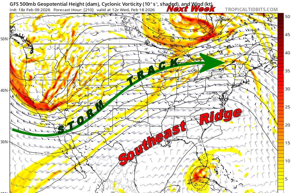
Vague post is vague06z Euro.. this weekend storm is weird man.
Got youVague post is vague

Google had exact same track just not as cold
You got them total qpf maps

Thank you! I do love the fact that both have reduced qpf in the snow hole. We can't get into a new pattern soon enough..
Avg high is 33 here for Feb! This pattern is winning! I’m sure the
Flip flops it isGeez now that the sun is up the tempest said

@ 815am 43 at GSP and 32 in Pickens. Urban local high point meet rural local low-ish point. And Pickens probably still ends up just as warm or warmer todayFlip flops it is View attachment 194010

 www.seatemperature.org
It's a weird storm track to me, almost due east, southern slider kinda with Miller A like precip along the coast. I see no reason it's not much further north with a line of showers/storms by verification time lolThank you! I do love the fact that both have reduced qpf in the snow hole. We can't get into a new pattern soon enough..
It finally loaded for us cheapskate folk on tidbits. That setup isn't that bad just need that leading wedge to beef up. If you were to draw up how you'd do a late winter beast, that isn't that far offIt's a weird storm track to me, almost due east, southern slider kinda with Miller A like precip along the coast. I see no reason it's not much further north with a line of showers/storms by verification time lol
i agree on the weird part. it seems to be sort of buried in a general ridge and the AIFS keeps enough above normal heights over top to stop it from going anywhere, + it is a more pos tilt weak system on that model so it doesn't really try to gain latitude. the 0z euro basically corrected to the AIFS precip footprint, but then went back to the more amped solution at 6z to bury charlottesville. meanwhile in GFS land it tries to cut off a weak ULL and send it to Florida lol?It's a weird storm track to me, almost due east, southern slider kinda with Miller A like precip along the coast. I see no reason it's not much further north with a line of showers/storms by verification time lol

0z Euro Perfect track if it was only cold enough / ugh. Canadian and Icon cut up west and flood us all, but 6z icon has trended back toward 0z euro. Canadian has Ice in nw NC. But is out to lunch with trackIt's a weird storm track to me, almost due east, southern slider kinda with Miller A like precip along the coast. I see no reason it's not much further north with a line of showers/storms by verification time lol


Exactly. This just isn’t like so many Februarys we’ve seen of late in which the cold was leaving Canada and heading back to Siberia. The cold is still there close by and there is one heck of a snow over the northeast and Ohio ValleyI might agree with you if all of the cold was going to evacuate Canada.


